
Analysis: How the UK’s ‘insane’ 40C heat was forecast ‘weeks in advance’

The UK has provisionally breached 40C for the first time ever, reaching 40.2C at London Heathrow airport. Before this heatwave, temperatures of 40C had never even been forecast for the UK – let alone recorded.
Yet earlier this month, scientists began sharing the first-ever weather forecasts predicting 40C temperatures in the UK for mid-July. That a model could project such temperatures in the UK was unusual, scientists said, but they stressed that such heat was unlikely to materialise.
As the days passed, however, more and more models began to converge on higher temperatures – and the likelihood of seeing 40C heat in the UK rose steadily.
The UK Met Office implemented an “amber” weather warning a full six days before the heatwave struck – the earliest heat warning that it has ever released. And, by 15 July, the Met Office released its first ever “red” warning.
This is “the most insane weather story I have seen in this country”, a meteorologist tells Carbon Brief, adding that “the silent revolution of weather technology and understanding allows meteorologists to share life-saving information days in advance”.
How do scientists forecast heatwaves?
Weather is “chaotic”, meaning that small changes in temperature, wind or humidity can have a significant impact on conditions hours or days later. This feature of the Earth’s atmosphere and oceans is often called the “butterfly effect”.
However, chaos can make it tricky to produce accurate weather forecasts – as even small errors in the “initial conditions” of a forecast can result in inaccuracies that grow as the forecast runs into the future. This means that as the “lead time” of the forecast increases – the time between the forecast being made and the event happening – it can become less accurate.
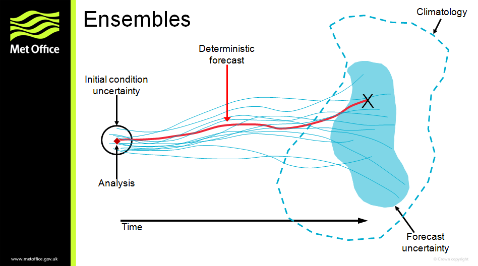
To account for inaccuracies, forecasters often use a large group of simulations called an “ensemble”, which are each run with slightly different starting conditions. By looking at the range of outcomes, forecasters can determine which outcome is the most likely.
This is shown in the graphic below, with the blue lines indicating the simulations in an ensemble and the blue blob showing the spread of potential outcomes. The red line shows a single “deterministic” forecast for comparison.
Aidan McGivern is a senior weather presenter at the UK Met Office. He tells Carbon Brief why ensemble forecasting is important:
Weather forecasts have improved significantly over the past 50 years. Dr Simon Lee – a research scientist at Columbia University in New York – tells Carbon Brief that “for large-scale patterns across the northern hemisphere, a seven-day forecast today is about as accurate as a five-day forecast in 2000 or a three-day forecast in the 1980s”.
Meanwhile, the Met Office’s four-day forecast is now as accurate as a one-day forecast was 30 years ago. McGivern tells Carbon Brief that this is in part due to improvements in individual models – for example, higher spatial resolution – and partly because more model runs can now be produced simultaneously, thanks to greater computing power.
The UK 2022 heatwave
On 23 June, the European Centre for Medium-Range Weather Forecasts released the results of a 32-day “subseasonal” forecast model run, which predicted unusually high temperatures for 18-25 July over the UK and US.
This model run was the first indication of what would eventually become an unprecedented heatwave, attracting global media attention. However, at the time, it was not given much attention, as it was only one in a large range of available model runs. Furthermore, Lee tells Carbon Brief that this type of forecast is “generally low in skill”, meaning not particularly accurate.
On 1 July, one of the 30 model runs produced by the Global Ensemble Forecast System predicted temperatures of 40C in the UK for 14 July. Scientists stressed that these temperatures were unlikely to materialise, given the limited number of model runs suggesting extreme temperatures. Nevertheless, some highlighted this result as “historic”.
Possibly the first time 40°C has appeared in a reliable operational medium-range ensemble forecast for the UK. https://t.co/NRttTCOdjA
— Dr Simon Lee (@SimonLeeWx) July 1, 2022
As the days went on, model runs from a range of institutions continued to suggest high temperatures around the middle of July. McGivern tells Carbon Brief how the likelihood of high temperatures increased over July:
The Met Office released an amber warning on 11 July, stating that “exceptionally high temperatures are possible from Sunday [17 July], lasting into early next week”.
“It’s still not often that so many computer models agree on the weather and temperatures more than five days ahead,” McGivern tells Carbon Brief. He adds that this six-day lead time “is further ahead than most weather warnings – and certainly most amber warnings – that the Met Office tend to issue”.
The day after the warning was released, the Met Office press office told Carbon Brief why the warning was released so early:
Amber warning of Extreme Heat issued at the maximum lead-time for an operational weather warning from the Met Office.
— Dr Simon Lee (@SimonLeeWx) July 11, 2022
And no, it's not "just summer", the clue is in the use of the word Extreme. https://t.co/RuM5CpmM6U
On 13 July, the Met Office global model showed maximum temperatures of 40C in parts of central England on 19 July. Met Office senior forecaster Alex Deakin explained in a video posted to Twitter that, “at this stage, 40C is possible early next week, but unlikely, with [the] chance being less than 10%”. However, he added:
On 15 July, the Met Office issued its first-ever red warning for “exceptional” heat across parts of England. In a press release, the organisation said “this is the first time we have forecast 40C in the UK”.
For the first time temperatures of 40°C have been forecast in the UK and the first ever Red warning for exceptional heat has been issued.
— Met Office (@metoffice) July 15, 2022
Find out more in our press release 👇
Met Office chief meteorologist Paul Gundersen added:
Having watched computer models converging on this forecast, I kept hoping some weird glitch was going on and they’d back off the extreme heat. But this is just two days away…41C may sound unbelievable but it is looking likely and it will be hugely impactful for many many people! pic.twitter.com/Et6uAxeCW6
— Sarah Keith-Lucas (@SarahKLweather) July 16, 2022
The Met Office raised its heatwave forecast on 17 July, giving a 90% chance of the UK seeing a temperature record in the upcoming week and a 60% chance of reaching 40C.
This story of increasing model certainty is similar with different forecasting centres. On 18 July, ECMWF released a press briefing, stating that the heatwave “was forecast at least three weeks in advance, but, until last week, there was significant uncertainty about the extent and severity of the heatwave”.
This is “the most insane weather story I have seen in this country”, meteorologist Scott Duncan tells Carbon Brief – likening the UK heatwave to the “record-smashing” temperatures seen in the Pacific northwest last year.
“It’s been remarkable that we’ve seen extreme scenarios picked up by ensembles at the longest lead-times,” Lee says.
Duncan adds:
Forecasting unprecedented events
Temperatures of 40C are already 10 times more likely in the UK than they would have been in a world without climate change – but this milestone temperature is still only expected once every 100-300 years in the current climate.
Nevertheless, as the climate warms, temperature records will repeatedly be broken, as increasingly hotter temperatures are reached around the world.
Prof Hannah Cloke, professor of hydrology at the University of Reading, tells Carbon Brief that climate change can make it “tricky” to forecast extremes, because they are often unprecedented in the historical record. Cloke explains:
Dr Rebecca Emerton – a research scientist at the ECMWF – adds that “based on the science and our understanding of the Earth system, [models] can simulate how events might unfold, including events that we’ve never observed before but are physically possible”.
Nevertheless, Cloke tells Carbon Brief that the ability of models to “predict the unprecedented” is one of the more “exciting” advances in modelling.