By Sayanangshu Modak
Time and again, the question of dams being constructed by China on the Yarlung Tsangpo (also known as Siang or Dihang in Arunachal Pradesh) – the main tributary that feeds the Brahmaputra river in Assam, has caused quite a stir in India. A recent opinion piece states that China will begin the operations of 360 megawatt-Jiacha Hydropower Station in Gyatsa County of Tibet Autonomous Region from August 2020, thereby making the sensational claim that it would ‘choke off’ the flow of the Brahmaputra in India. The author calls the construction of dams by China as a political quagmire, thereby placing it in the larger canvas of emerging hostilities between the two Himalayan neighbours post the deadly conflict in Galwan Valley. With this clear standpoint, two possible outcomes have been laid out by the author – India opposing or blocking the construction of dams through military interventions or by allowing it to happen and living with the consequences. Alarming as it may seem for the uninitiated, the entire premise of ‘choking’ the flow – on which the two extreme scenarios have been created, appears to be another case of linear thinking which has only led to the creation of scientifically unfounded perceptions in the downstream of the river.
Where’s the water to ‘choke’?
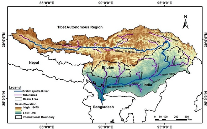
The Brahmaputra sub-basin consists of a highly complex drainage system. It is fed by tributaries that drain four sovereign nation – China (50.5%), India (33.6%), Bhutan (7.8%) and Bangladesh (8.1%). Out of the total length of 2,880 kilometres, about 1,625 kilometres flow through the Tibetan plateau which has an average elevation that is higher than 3000 metres above mean sea level. This creates an impression that the larger share of the basin in Tibet, as well as the longer chainage of one of the main tributaries of the Brahmaputra – the Yarlung/Siang, must accrue for the largest share of the total discharge of the Brahmaputra. However, the reality is far from this make-believe notion of water insecurity in the downstream.
Figure 1: The Brahmaputra Basin
The Brahmaputra gets its name after the confluence of three major tributaries – Luhit, Dibang and Siang/Dihang near the town of Sadiya in Assam. Thereafter, it is joined by various other right bank tributaries with a glacial origin like Subansiri, Jia Bhareli, Manas and Teesta and comparatively lesser number of left-bank tributaries, all of which are fed by spring water like the Burhi Dihing, Dhansiri and Kopili river. As such, the percentage of glacier melt in river flow is approximately 12%. A report by the IWMI puts these estimates at an even more conservative – 2% glacier runoff contribution and 2% seasonal snowmelt contribution to the Mean Annual Flow (MAF).
Moreover, about 75% of the basin’s glaciers are concentrated in Southeastern Tibet and Eastern Himalaya while only 25% of it is located in Southwestern Tibet that will provide the bulk of the flow to run the turbines of the Jiacha dam. A large part of the meltwater that is generated in the upper and middle reaches of the Yarlung’s basin also gets evaporated quickly due to the low air humidity and cloudless weather conditions. Therefore, instead of glacial and snow-melt, it is important to consider the spatial distribution of rainfall in the basin to get a proper idea of what feeds the flow of the river which is of importance to the regions in the downstream.
Rainfall creates the flow
The Himalaya stands as an orographic barrier to the movement of moisture-laden air currents that blow in from the Bay of Bengal as part of the South West Monsoon. Whatever moisture that reaches the high Tibetan Plateau (TP) finds its way through a moisture corridor that runs parallel to the Great Bend of the Yarlung Tsangpo. This corridor connects the cold and dry TP with the rainfall endowed region located on the south aspect of the Himalaya. As seen clearly in the map below from Ghosh et al. (2019), the rainfall declines considerably along the great bend of the Yarlung Tsangpo as one moves upstream from Tuting. As identified through the isohyets in the map, the mean annual rainfall in Nuxia is only 500mm while just 278 km downstream, it increases to more than 3000 mm at Tuting. The Jiacha town, which is close to the site of the dam, is located further 270 km upstream of Nuxia and due to its location, experiences conditions that are even drier than that in Nuxia.
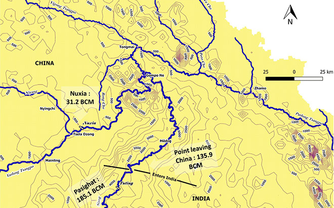
As a direct consequence of the rainfall received in various parts of the catchment, the discharge of the river also increases manifold as the Yarlung/Siang bends around the Himalaya and emerges from the mountains and onto the plains of Assam (Ref. Fig 2). This can be identified from hydrographs at Nuxia and Bahadurabad. The maximum flow during July and August is 45,000 cumecs in Bahadurabad, which is ten times more than 4500 cumecs in Nuxia during the same months of the year. Moreover, according to a study by Lutz and Immerzeel (2013), around 25 % of the flow is generated by glacier and snow-melt in the upper catchment of the Siang river (which includes the great bend) while 75% of it is fed by rainfall alone – the bulk of which is generated downstream of Nuxia due to the orographic factors mentioned above.
The annual discharge along the length of the Brahmaputra further increases as the river flows downstream of Sadiya as a wide channel of an average width of 5.46 km to accommodate the additional water that is fed by the various left-bank and right-bank tributaries mentioned above. Comparatively, the width of the Yarlung’s surface in its middle reach, at the Jiacha Gorge where the dam has been constructed, is only a minuscule fraction of this – ranging between 200-400 m.
Setting the priorities right
The article claims that the Jiacha dam will choke the Brahmaputra, unleashing ecological damage in the downstream and robbing people of their socio-economic dependence on the life-nourishing waters of the river. This claim does not just fail to stand the test of hydro-meteorological scrutiny but also discounts the fact that there will be no water diversion. Moreover, the altered flow regime due to hydropeaking will be negated by the sheer volume of discharge that gets generated downstream of Jiacha and on the south aspect of the Himalaya. Therefore, it is imperative to situate the hydro-diplomacy between the two Himalayan neighbours in a scientific query that would enable the process to see through the cacophony of sensationalism and prioritise on the importance of cooperation.
Presently, the need to expand the ambit of cooperation beyond state actors is more pertinent than ever before. Cooperation should look outside Track 1 diplomacy that limits dialogues and negotiations to those taking place only between officials. The multi-track cooperation may involve stakeholders across transboundary nations and sectors to initiate and sustain a process of dialogue. Such dialogues may feature issues of mutual interest and importance such as flood management, riverbank erosion, hydropower, waterways, ecology etc and pave the way for the creation basin-wide knowledge and enhanced cooperation among the scientific and policy advocacy community.
All riparian nations should refrain from any knee-jerk reaction in this vitiated climate of geopolitics in the region that may devour the years of progress that has been made by states in establishing mechanisms of hydro-diplomacy. A testament of this is the India-China Expert Level Mechanism (ELM) on Trans-border Rivers and the hydrological data (water level, discharge, and rainfall) sharing agreement that exists between India and China on the Yarlung/Brahmaputra and Langqen/Sutlej, which has remained functional despite the hostilities at the Line of Actual Control.
The views expressed above belong to the author(s).