Community science project helps track geohazard risks in Uganda
Senior citizens are among a group of volunteers helping to build a picture of geohazard risk in a populous mountain region in Uganda. Localized data from this initiative aim to identify communities vulnerable to landslides and flooding and to lead to improved early-warning systems.
The Kigezi Highlands is a tropical region in southwestern Uganda that has undergone significant population growth in recent decades. Fertile soils attract subsistence farmers, who typically grow potatoes, climbing beans, and sorghum, used to make a popular local brew.
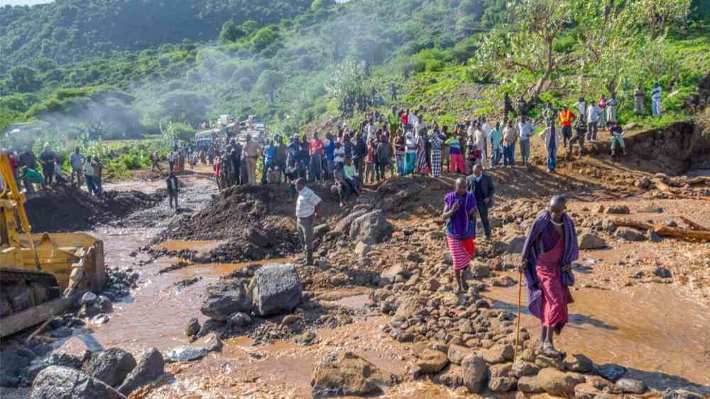
Landslides and floods are a part of everyday life in Kigezi, as the steep slopes of the Virunga Mountains and annual rainfall of between 1,200 and 1,300 millimeters lead to high erosion rates. Today the threat is growing as farmers cultivate hillsides that had historically been pastoral land and as infrastructure expands. Landscapes are increasingly fragmented, and more people are living in the vicinity of hazards.
“Most farmers in the Kigezi Highlands have lost crops during the rainy season, and that brings a high risk of famine,” said Violet Kanyiginya, a geoscientist from Mbarara University of Science and Technology in Uganda who is currently based at the Royal Museum for Central Africa in Belgium.
Kanyiginya coordinates a project to track hazard risks in the Kigezi region, which she presented at the European Geosciences Union General Assembly 2022.
In 2019, Kanyiginya’s team collaborated with the district disaster management committee to identify Kigezi parishes that face the highest risks. They appointed 15 “geo-observers” from local communities who were trained to report information on eight different natural hazards using a smartphone app. In 2020 the team was expanded to include “river watchers,” who record daily stream levels in eight different catchment areas.
Once geo-observers become aware of incidents—often via contacts in their communities—they travel to the site to take photos and ascertain details, including hazard type, when it happened, and the scale of the affected area. Within the first 24 months, geo-observers identified 266 natural hazards, with landslides being the biggest risk.
Each geo-observer is provided with a phone, mobile data, and money to cover transportation costs. Crucially, Kanyiginya said, they are not paid for their time. “We want local people to own [these] data and feel like [they are] their own,” she explained.
Kigezi residents cite several motives for becoming involved in the project, with the desire to become a spokesperson for the community being a common thread. “I wanted the world to know about the disasters in our community,” said one geo-observer in conversation with the project team. Another shared that “being a geo-observer has made me famous in the community—this helped me to even win the recently concluded political campaigns.”
Coproducing a Timeline of Environmental Change
In an additional part of the project, Kanyiginya’s team engaged more than 100 senior citizens (most aged between 70 and 80 years) to build a picture of how the local landscape changed over the past 60 years. People who were mobile met to take part in mapping workshops. Older or less mobile members of the community received home visits.
Socioeconomic and historic information anchored participants’ memories to specific periods. For instance, they were asked to describe what roads, wetlands, animals, or natural hazards existed during the rule of President Idi Amin, who led Uganda between 1971 and 1979. Common narratives from different periods emerged and were corroborated against historical photos and a series of satellite images. The exercise reinforced the findings that hazard risk is increasing with land use changes, such as cultivating hillslopes, abandoning fallowing practices, and replacing natural tree species with exotic ones.
“Memorialization of past hazardous events is so important in disaster risk reduction,” said Anna Hicks from the British Geological Survey, who researches crowdsourced and community science methodologies. “Inviting older community members to share their experiences of past landscapes—both social and physical—and how they’ve changed over their lifetimes, is a powerful process for both storyteller and listener.”
Making the Data More Reliable
The Kigezi work is part of a larger program in Uganda that previously established a geo-observer network in the nearby Rwenzori Mountains in 2017. A recent analysis of the Rwenzori network found that geo-observer data are more precise than satellite-based data for landslides and floods, with fewer false positives.
Human errors do creep into the data, however. Geo-observers sometimes confuse natural wetlands with flooded regions or enter the wrong dates, and their photos do not always reveal the hazard itself. To reduce these errors, annual refresher workshops tackle common issues.
Funding has been provided for the Kigezi project to run until the end of 2023, and it will be followed by a 10-year related project covering a wider area. Jonathan Paul, a geoscientist at Royal Holloway, University of London, believes the key to long-term success in crowdsourced and community science projects is to integrate data collection into people’s everyday routines, by, “for instance, using social media or WhatsApp, instead of an entirely new app that may not be very easy to use,” he said.