Integrating Earth science research and observations into adaptation planning helps identify effective strategies to manage climate risks.
By Vivek Srikrishnan, Richard Alley, and Klaus Keller
Climate change caused by past and ongoing emissions from fossil fuel burning poses sizable risks for current and future generations through its impacts on multiple interacting sectors, including, for example, food and water supplies and public health.
The extent of these risks is subject to deep uncertainties and tipping points, suggesting the need for flexible approaches to climate adaptation. One example of a deep uncertainty in our understanding of climate is the degree to which local and regional storm surge intensities are modulated by a warming climate.
In climate risk management, these uncertainties often affect estimates of potentially damaging impacts, thus amplifying the importance of the uncertainties.
Even with strong mitigation of anthropogenic climate forcing, communities will still need to adapt to impending changes resulting from historical greenhouse gas emissions. Successful strategies require the right information, such as observations of relevant environmental indicators, or signposts, to trigger needed changes in the approach, and updated risk assessments that account for new information.
Fundamental Earth science research provides a foundation for supplying this information. Integrating research about regional- and global-scale Earth system processes into adaptation planning can help identify strategies to manage climate risks in the face of the uncertainties to ensure sustainable and resilient communities. We illustrate this point with an example of decision-making to adapt to sea level rise in Norfolk, Va.
Protecting Norfolk: A case study
Consider the decision of how high to build a levee to help protect Norfolk, which sits along the Elizabeth River at the south end of the Chesapeake Bay. Suppose that decision-makers seek flood defense systems to limit the chance that by the year 2070, floodwaters will overtop the levee to 1% in a given year, corresponding to an event with a 100-year return period. Planning to meet this target requires projections of sea level rise and storm surge. These projections hinge critically on assumptions about climate policies and the strength of physical feedback mechanisms governing, for example, ice sheet and storm surge dynamics.
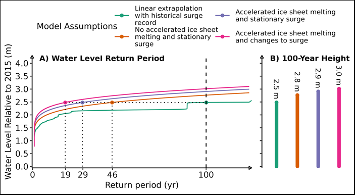
According to our modeling, making seemingly reasonable assumptions about future flooding on the basis of recent historical tide gauge records alone could lead planners to suggest a levee height of roughly 2.5 meters (Figure 1, green curve). However, this choice of levee height could result in drastically higher (and arguably unacceptable) flooding risks if some of these assumptions fail. For example, if Earth’s ice sheets respond rapidly and nonlinearly to increased climate forcing (as they have likely done in the past and may be doing now) and if storm surge frequency and/or intensity increase with a warming climate (which may be consistent with existing evidence), then the projected probability of floodwaters overtopping a 2.5-meter-tall levee rises to just over 5% per year (Figure 1, pink curve) in this example analysis. In other words, what might have been considered a once-in-a-century flood event would occur approximately every 19 years on average.
An alternative might be to build a levee high enough to defend against the perceived worst-case scenario. Using an example worst-case assumption established by the National Oceanic and Atmospheric Administration in the case of Norfolk might lead to construction of a levee roughly 4 meters tall. This strategy might be logistically infeasible, however, and would likely require very large investments that some might feel could be better spent elsewhere.
How can we manage trade-offs between competing concerns given the deep uncertainties in our knowledge of climate? One approach is to hedge in the short term against immediate and foreseeable risks, then adapt as new information becomes available. By analogy, if a doctor tells you that you have an increased risk of heart disease, it might be prudent to adapt your behavior initially by moderately modifying your diet and exercise habits while leaving open the option to use more intensive approaches, such as prescription medication, if your perceived risk does not decrease sufficiently in the future.
Health risks can be better managed with sustained observations (checkups, blood tests, etc.) and analyses. Similarly, climate risks can be better managed with sustained Earth observation systems and research, so that science can inform decisions. What does this mean for designing, implementing, and resourcing mission-oriented basic science?
For coastal flood risk management, several unknowns can be addressed by analyzing basic Earth science questions: (1) What are the impacts of possible future greenhouse gas emissions trajectories, including on relatively low probability but high-risk events? (2) Will the West Antarctic Ice Sheet (WAIS) collapse, and if so, on what timescale? (3) What would be the resulting contribution of WAIS collapse to local sea level changes? (4) Are there detectable changes in the frequency and severity of storm tides? (5) Are storm tracks changing as a result of climate change? (6) What regions and metropolitan areas are more likely to be affected?
Designing adaptive strategies that can react to new information from Earth science observations can drastically improve future outcomes in the event of potentially damaging flood events. Current mitigation measures can be planned with an eye toward flexibility and expandability so that the full suite of appropriate options is available in the future. As an example, while new levees are being built or existing levees heightened, it might also be prudent to build them so they could be widened and further heightened in the future. In the Norfolk example, consider again a levee designed to defend against floods with return periods shorter than 100 years as of 2070 when the levee height—2.5 meters—is based only on linear extrapolation from the historical record (Figure 1, green curve). By comparison, even under relatively conservative model assumptions, considering a consistent storm surge pattern out to 2070 but ignoring the potential for accelerated West Antarctic melting (Figure 1, orange curve), that 2.5-meter levee would protect only against floods with a 46-year average return period, less than half of the target standard.
Integrating disciplines such as Earth science, statistics, and decision analysis into adaptation planning can help identify signposts that can be used to design monitoring systems and trigger potentially needed changes in strategy. A simplified and potentially effective adaptive approach at Sewells Point, near Naval Station Norfolk, might involve the following steps:
First, heighten the levee in stages over the next few decades to maintain a 100-year protection standard against well-characterized risks—say, the nonaccelerated sea level rise scenario in Figure 1 (orange curve)—with enough width built in to increase the height in the future if necessary. Second, plan for transitions between scenarios (e.g., from orange to blue to pink in Figure 1) to avoid being locked into a single approach. And if the projected levee height needed to meet the target protection standard in certain scenarios is more than what might be tolerated on the basis of cost or aesthetic objections, the possibility of using other resiliency measures—elevating houses, property buyouts, or land use changes, for example—should be left open. Third, monitor signposts, such as changes in ice sheet dynamics and trends in regional tide gauge records, for indications that the local flood risk could change. Finally, update risk assessments and mitigation strategies with this new information.
Effective adaptation requires investment
Such adaptive strategies can drastically reduce risks and/or costs, but they do require sustained investment to realize these benefits. The example outlined above requires investments in sustained Earth observations and analysis aimed at understanding and early detection of climate change impacts. Remote sensing observation platforms provide broad-based benefits, increasing the economic value of the gathered information. The benefits of such information are regional in the case of storm surge trends and global in relation to ice sheet observations.
Finally, various adaptation strategies can be analyzed and compared to shed light on the trade-offs associated with choosing among the strategies (trade-offs related to costs, externalities like property values, and flood hazards, among others). Ultimately, the selection of a strategy requires balancing and compromising among diverse stakeholder perspectives and objectives. Multiobjective decision analysis can help identify strategies that best navigate the often hard trade-offs that arise, and careful articulation of objectives and trade-offs helps to improve the transparency of the decision-making process.
This opinion focuses on the issues of sea level rise and flooding affecting one example site. Similar plans would be required to address a wide range of other issues posed by the changing climate, which are likely to become more challenging if mitigation measures are not implemented.
Efforts to defend against climate-related risks benefit from sustained commitments to getting the right science, getting the science right, and getting the science to the decision-makers. Investments in basic Earth science observations and research enhance our ability to identify meaningful signposts for adaptation, to understand the risks associated with tipping points, and to realize the benefits of sound risk management strategies.