USA: Land use planning more effective than logging to reduce wildfire risk
By Kelly Pohl
For communities land use planning is more effective than logging on federal lands to reduce future wildfire disasters
The President issued an executive order last month that instructs federal land managers to treat 8.45 million acres of land and cut 4.4 billion board feet of timber. But land use planning, not logging on federal lands, is a more effective tool to confront future wildfire disasters.
This President’s executive order represents a significant increase in timber harvest compared to recent years—roughly 80 percent more than was cut on U.S. Forest Service lands in 2017—but is minor compared to cuts in the 1980s, which reached more than 12 billion board feet.
Timber management on federal lands can be justified for valid reasons—including watershed protection, wildlife habitat conservation, and overall forest health—but it rarely helps our communities confront looming wildfire disasters in the face of a warming climate and continued home building on fire-prone lands. Better land use planning and improved design of our built environment is our best bet at reducing risk from wildfires.
Logging on federal lands will do little to reduce wildfire risk to communities
In some ecosystems, fuel treatments can slow fire spread and reduce fire severity. But the geography of where timber harvests are placed—often determined by road access, marketability of timber, and local conditions—is likely to misalign with the spatial patterns of wildfire—determined not just by fuels, but also by ignition sources, topography, and weather.
For fuel treatments: Quality over quantity
According to a recent analysis, only 1 percent of U.S. Forest Service areas treated for fuel reduction experienced wildfire in the decade from 2005-2014. From 2000 to 2015, almost 17 million acres of federal land were treated for fuels reduction, equating to approximately four percent of U.S. Forest Service and Bureau of Land Management lands. During the same time period, more than 93 million acres burned. The odds of putting fuel treatments in the wrong place are extremely high.
Even if federal land management agencies were able to increase their treatments and meet the President’s goal of treating 8.45 million acres, it would still equate to less than 2 percent of all federal lands. It is unlikely these locations will be among the hundreds of millions of acres that burn during the effective lifespan of a fuel reduction treatment—typically 10-20 years.
Most wildfires are in grass and shrubs
Importantly, most wildfires aren’t in the trees, but in grasslands and shrublands. Approximately 60 percent of wildfires happen in flammable grasses and shrubs, which require different mitigation strategies such as mowing and brush removal.
If the goal is risk reduction for communities, placement of fuel treatments should be strategic for maximum effectiveness. Research shows that home loss is primarily determined by two factors: the vegetation in the immediate area around the home, and the way the home is designed and constructed.
Modifications to this area, known as the home ignition zone, are more effective at protecting communities than fuel treatments on outlying federal land. Fuel treatments within 100 to 200 feet of homes can make a meaningful difference, which often requires treatment on private land—not on federally managed forests.
Houses are fuel too, often endangering entire neighborhoods
Most wildfire disasters start from embers that travel a mile or more ahead of a fire. These sparks can disperse across the landscape and ignite homes scattered away from the flame front. Embers exploit small vulnerabilities in homes, for example entering through an attic vent, igniting debris in a gutter, or sparking adjacent landscaping that will then burn the siding, windows, or doors of a home. Once on fire, a home can ignite neighboring homes, leading to a neighborhood conflagration.
The homes themselves—generally made of highly flammable wood and plastics—become fuel and generate more intense heat than vegetation. This is why it is common to see post-fire photographs (like the one at left) where the remnants of incinerated houses appear next to unharmed, standing green vegetation.
If we begin to think of houses—not just trees—as potential fuel to a fire, it may change how we build our communities. We shouldn’t be focusing on logging and we don’t necessarily have a wildfire problem. What we have is a home-ignition problem.
Here is what we can do: integrate fuel reduction and community planning strategies to better manage risk.
Reduce the fuel created by houses through better land use planning
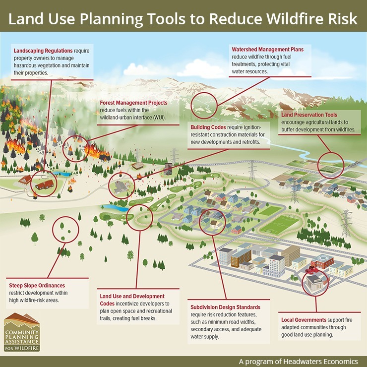
Fortunately, we have the knowledge and tools to reduce risk posed by homes in wildfire-prone areas. As the figure below shows, there are many land use planning tools available that can mean the difference between home survival and loss. Tactics for areas of high hazard include:
• require wildfire-resistant building materials and design features
• prohibit the storage of flammable materials (like firewood and propane tanks) in areas around homes
• use slope setbacks to distance homes from hills where fires move quickly
• reduce new home development in the areas of highest risk
• develop approved plant lists and require homeowners maintain vegetation around the home
• maintain parks and open space around a community to reduce fuel
Land use planning is more effective to reduce community wildfire risk
The costs of such strategies are often minor, and certainly they pale in comparison to the costs communities suffer when they experience a wildfire disaster. With thousands of U.S. communities at-risk, wildfire mitigations for communities are an immediately available, but underused solution.
Thirty communities across the U.S. are applying these strategies through the Community Planning Assistance for Wildfire program, which gives free assistance to communities ranging from rural counties to larger metropolitan areas. The program provides strategic recommendations, wildfire hazard maps, trainings, and custom research to improve land use planning for wildfire.
Across the U.S., Housing growth in fire-prone areas is faster than in other land use types. In the west, nearly half of the population already lives in these areas, and since 1990, 60 percent of new homes in California, Washington, and Oregon have been constructed there. Housing growth in western Montana is fastest in areas of highest wildfire hazard.
Fuel treatments on federal land won’t be enough to reduce our risk. Fortunately, we have land use planning tools ready today that can help us live with wildfire.