Tropical Cyclone Harold challenges disaster and public health management
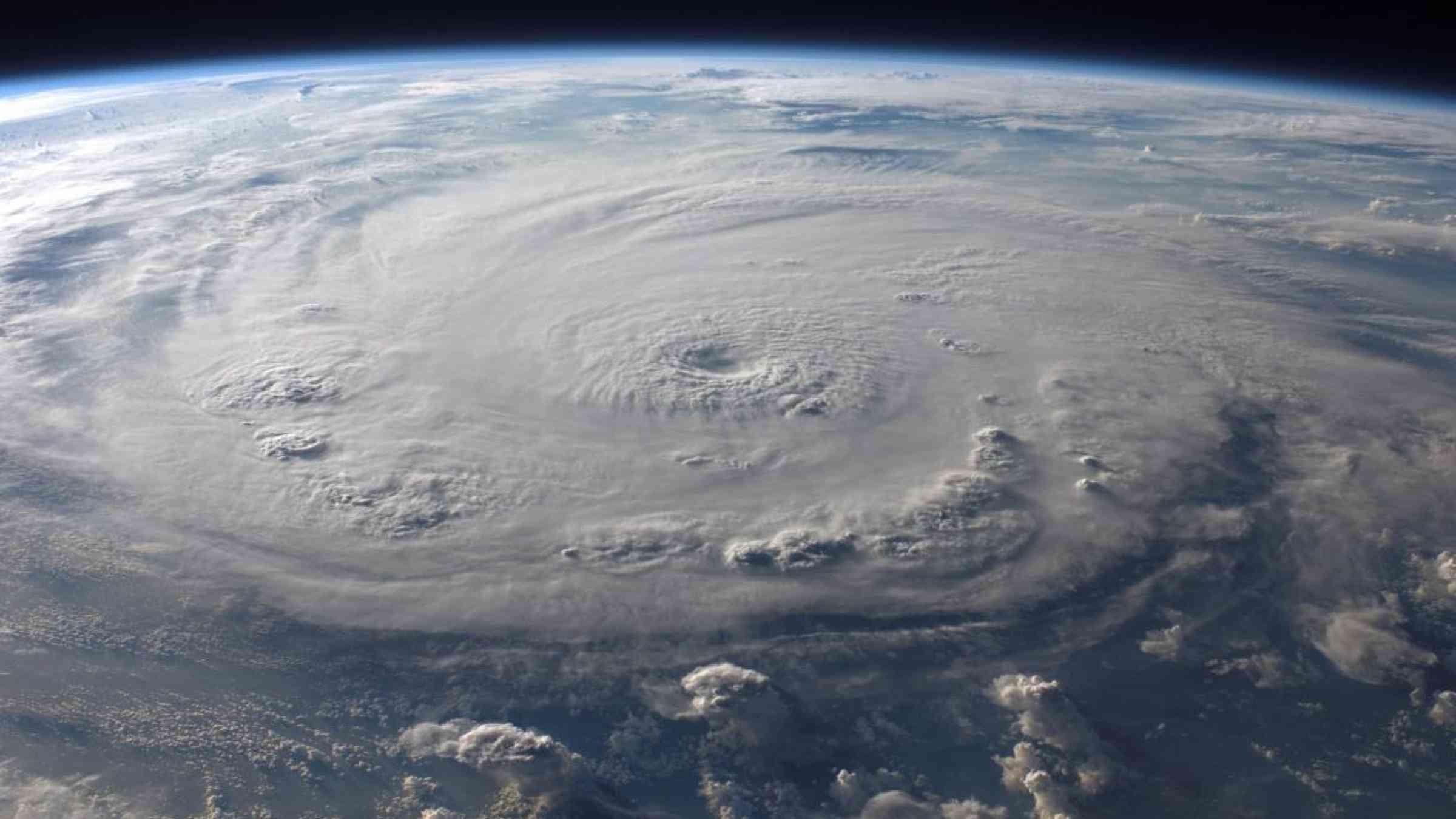
Low-lying islands in the South-west Pacific Ocean are counting the human and economic toll of Severe Tropical Cyclone Harold, which destroyed key infrastructure and highlighted the challenges of disaster and public health management in the COVID-19 era. At its peak, Harold was the equivalent of a Category 5 level hurricane on the Saffir-Simpson scale.
UN Secretary-General António Guterres said he was “deeply saddened” by reports of loss of life and property in Vanuatu, Fiji, the Solomon Islands and Tonga.
“The Secretary-General commends the governments and first responders in the affected countries for their pre-emptive work to make people safe ahead of the storm and to meet their immediate needs afterwards. The United Nations stands ready to support these efforts,” he said in a statement.
“The Secretary-General expresses his deep solidarity with the people of the Pacific as they face the impact of this cyclone, along with other climate-related challenges, as well as the coronavirus pandemic, which adds a worrying new dimension to existing vulnerabilities,” he said.
The tropical cyclone underlined the imperative of activities of all WMO projects that help to strengthen early warning systems and increase resilience of vulnerable Members impacted by severe weather and climate change associated hazards such as coastal and inland flooding, including from storm surge, river floods, and rising sea levels.
The coordination of the forecasts and early warnings for tropical cyclones in the region is provided by the WMO Tropical Cyclone Committee for the South Pacific and South-East Indian Ocean, structured with the Regional Meteorological Specialized Center in Nadi, Fiji, and the National Meteorological and Hydrological Services.
The WMO-supported Climate Risk and Early Warning Systems (CREWS) is helping to strengthen early warning systems and increase resilience in Pacific Islands. This includes through seeking to strengthen the ability of the Regional Specialised Meteorological Centre (RSMC Nadi) within the Fiji Meteorological Service to support other Pacific Islands; and enhances the capacity of the national hydrometeorological agencies of Pacific Island Countries and Territories to provide impact-based forecasts of extreme weather events.
Solomon Islands
Harold impacted the Solomon Islands during the hours of 1 to 4 April 2020 with devastating winds accompanied by heavy rains, river flooding, very rough seas, high oceans waves and coastal flooding including storm surges.
It passed through Solomon Islands territorial waters as Category 2 as it tracked further southeast into Vanuatu by 4 April 2020 gaining more strength and being upgraded to Category 5.
Solomon Islands National Emergency Operation Centers (NEOC) provided coordination support to the Provincial Disaster Committee (PDC) of each of the four affected provinces to conduct Initial Damage Assessments (IDA). A preliminary plan estimated that some 59,000 people have been affected. The storm added to the challenges already being faced by the people of Solomon Islands that is under a state of emergency, in an effort to reduce the spread of COVID-19 - although there are so far no cases of the virus.
27 people were reported missing at sea after being swept off a ferry MV Taemareho in rough seas conditions during the high swells caused by Harold. The ship was said to be carrying over 730 passengers on its journey from Honiara city to Malaita province when the incident happened at early hours of 3 April 2020.
WMO, with funding from the Climate Risk & Early Warning System (CREWS) initiative, will conduct national workshops on impact-based forecasting in October 2020. Seeing the importance of working together across different sectors, the session will bring together scientific experts, meteorologists and hydrologists, and practitioners from disaster management to discuss the processes of both Impact Based Forecasting and Risk Scenario planning.
Vanuatu
Harold, made landfall in Vanuatu on 6 April with sustained winds of more than 200 km/h – the equivalent of a category 5 storm both on the Saffir Simpson and Pacific scale.
Northern provinces were worst hit, with devastating winds, heavy rainfall and flash flooding. It caused power and telecommunications outages, substantial damage to houses and structures, and destroyed many agricultural areas and crops.
Initial assessments suggest as much as 90 per cent of the population in Sanma, the most affected province of Vanuatu, lost their homes, and more than half of all schools and almost a quarter of health centres were damaged. Crops have been destroyed and many communities are now cut off from help because of flooding and the destruction of roads.
Based on first aerial surveillance assessments carried out by Vanuatu’s National Disaster Management Office (NDMO), the total number of affected people is 159.474. The Vanuatu National Disaster Management Office is currently coordinating response to 4 disaster events – TC Harold, COVID-19, Tanna volcanoe ash falls and flash flooding on Teouma river on the island of Efate.
Overall coordination of the response in Vanuatu lies with the National Disaster Committee under the leadership of the Director General of the Ministry responsible for Meteorology, Geological Hazards and Climate Change. The Vanuatu National Disaster Management Office is implementing the response at the national level with clusters already activated for the COVID-19 response.
National disaster authorities had to lift bans on public gatherings of more than five people to ensure people made their way to evacuation centres.
In order to facilitate movement of humanitarian personnel as well as relief items, the Government of Vanuatu has eased in-country travel restrictions and also lifted all previous restrictions on domestic air and sea operations related to COVID-19.
Fiji
Harold hit the islands Vitu Levu and the islands to the east as a Category 4 in the night from 7 to 8 April 2020 causing power outages, blocked roads due to fallen trees, and widespread flooding. As of 14 April, more than 1,541 people were sheltering in 52 evacuation centres in Central, Western and Eastern divisions.
Fiji Government’s Divisional Commissioners have identified all evacuation centres (EC) that can be used and have estimated their capacity under COVID-19 rules. Social gathering restrictions and other COVID-19 protocols remained in force.
The Coastal Inundation Forecasting Demonstration Project for Fiji that was completed in November 2019, saw the Fiji Meteorological Service (FMS) operationalize a coastal flooding early warning system which allows for forecasting flooding sources from both ocean and river sources. Last week, it was used to determine the storm surge heights, recorded at approximately 6.5 metres, and estimations indicated that it was probably up to 8.5 meters in less sheltered areas.
FMS Director Misaeli Funaki said the coastal inundation forecasting system enabled the accurate recording of wave size and formed the basis of successful evacuation warnings to vulnerable communities. Unfortunately, some of the FMS outer island stations were severely damaged by storm surge, including Matuku, which was completely destroyed.
"Every instrument was destroyed. This includes communication equipment, observational instruments and the building," said Mr Funaki.
As Head of the RSMC Nadi, Mr Funaki noted that more work is required to help forecast the inland extent of inundation, not just for Fiji, but the region.
The Coastal Inundation Forecasting Demonstration Project in Fiji was funded by the Korea Meteorological Administration.
Early warnings in Fiji were additionally boosted by the Flash Flood Guidance System for Fiji which has been developed with funding from the Climate Risk & Early Warning System (CREWS) initiative and Environment and Climate Change Canada, and is implemented by WMO and the Hydrological Research Center. Under this system, flash flood threats and risks are computed and used operationally by forecasters. In conjunction with the Severe Weather Forecasting programme (SWFP), this seeks to strengthen the preparation and response to severe flash floods – and significantly save lives and livelihoods.
During the tropical cyclone, FMS used these products to issue several flash floods and heavy rainfall alerts and warnings in advance,while the National Disaster Management Office disseminated three public advisories related to heavy rainfall and flash flood warnings, advising the general public to be on alert and take precautionary measures from heavy rainfall and flash flooding.
High-resolution Numerical Weather Prediction (NWP) model products from the SWFP/ WRF-Fiji was developed by the Meteorology, Climatology, and Geophysical Agency of Indonesia, while RSMC Wellington is continuously providing severe weather forecast guidance.
Tonga
Significant damage to the water supply and food crops is reported across Tongatapu, because of the king tides and significant flooding. Destruction is widespread, including significant damage to homes, water supply and food crops is reported in 'Eua. The storm destroyed important tourist facilities. Inter-agency Initial Damage Assessment team led by NEMO has covered 1,700 households in Tongatapu and 889 in ‘Eua.