How ghost streams and redlining’s legacy lead to unfairness in flood risk, in Detroit and elsewhere
In 2021, metro Detroit was hit with a rainstorm so severe that President Joe Biden issued a major disaster declaration at state officials’ request.
Nearly 8 inches of rain fell within 24 hours, closing every major freeway and causing massive damage to homes and businesses. The storm was of a severity historically seen in Detroit every 500 to 1,000 years.
But over the past decade, the region has experienced several other storms only slightly less destructive, one in August 2023.
As the planet warms, severe rains – and the flooding that follows – may become even more intense and frequent in cities like Detroit that have aging and undersized stormwater infrastructure. These extreme events put enormous pressure on communities, but low-income urban neighborhoods tend to suffer the most
I am a geomorphologist at the University of Michigan-Dearborn specializing in urban environments, water, historical mapping and flood-risk equity.
My recent research, conducted with graduate students Cat Sulich and Atreyi Guin, has identified a hidden contributor to flooding in older, low-income neighborhoods that have seen a lack of investment: ghost streams and wetlands.
Although we studied Detroit, our research has implications for cities across the United States.
Historic decisions have an impact today
Ghost streams and wetlands are waterways that previously existed but, as urban areas built up, were either buried below the surface or filled in to support development. Detroit has removed more than 85% of the total length of streams that existed in 1905. Most major cities in the United States and Europe have removed similar numbers of streams.
Detroit is also a city deeply affected by redlining – a now-outlawed practice once used by the Home Owners’ Loan Corporation, a government-sponsored corporation that was created as part of the New Deal, that graded neighborhoods on perceived financial risk.
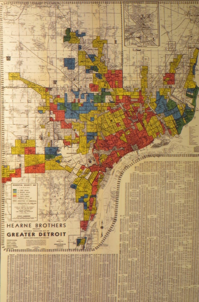
People living in communities labeled as “high risk” were disproportionately people of color, immigrants and residents of lower socioeconomic status and were systematically denied loans and opportunities to build generational wealth.
These neighborhoods received fewer community investments, including interventions such as stormwater infrastructure and landscape modification, than did higher-wealth neighborhoods.
We looked at whether these decades-old decisions have had any impact on flood risk today and learned that they do.
For this study, we correlated present-day flood risk in metro Detroit with former Home Owner’s Loan Corporation boundaries’ grades. Flood risk was mapped using the First Street Foundation’s Flood Factor, which scores every parcel in the U.S. on a scale of minimal (1) to extreme (10).
We then correlated flood risk to the presence of ghost streams and wetlands, which we extracted from old topographic maps from the United States Geological Survey. The goal was to determine whether a history of waterway burial and/or redlining influenced the overall flood risk of communities today.
We found that flood risk was disproportionately distributed, with historically redlined neighborhoods bearing the greatest brunt of flood risk.
Residents living in communities that were graded as “hazardous” (D) or “declining” (C) in the 1940s are today more susceptible to flood risk than the more affluent A and B communities. Over 95% of parcels classified at extreme flooding risk occur in C and D communities, with less than 4% in A and B communities.
Flood risk increases with the presence of ghost streams and wetlands, with C and D communities having a higher risk. In C communities, the presence of a ghost wetland increases flood risk tenfold, while ghost rivers also increase risk, although by a smaller amount.
The percent of properties in D-graded communities that are located adjacent to the 32-mile-long Detroit River and classified at extreme or severe flood risk is 99.9% if they have ghost wetlands or 95% if they have ghost rivers.
In other words, the combined history of redlining and landscape alteration may still contribute to increased flood risk today. When communities received poor grades, banks, lenders and municipalities neglected those areas’ stormwater infrastructure.
Invest resources where the risk is greatest
If communities want to protect residents from flooding, it’s crucial for them to map and understand their “hidden hydrology.” Few cities have the data to inform residents that they are at greater flood risk because they are living on a ghost wetland or river.
In Detroit, residents of most of the neighborhoods that show a major to extreme flood risk are not required to purchase flood insurance because they are not near an active river. This means residents are unknowingly at risk.
Another benefit to mapping ghost wetlands and rivers is that stormwater management is most effective if it follows natural pathways and processes.
Stormwater engineers frequently refer to this as “nature-based interventions” or “green stormwater infrastructure.”
During a flood, water occupies the lowest areas of a landscape, such as an abandoned stream valley or filled wetland. Those low areas are a good place to build green stormwater infrastructure, such as rain gardens that absorb water or bioswales that convey moving water.
Some solutions can reflect culture or embrace art: Detroit’s Charles H. Wright Museum of African American History installed permeable pavers with a unique West African-inspired design to minimize and manage floodwater following major flooding in Detroit in 2014.
In my view, marginalized communities need to have a strong voice in the search for solutions. Discrimination against these communities helped create the current problem. Listening to them now is key to both minimizing flood damage and beginning to right a historical injustice.