How England’s broken planning system has created (not reduced) the risk of floods
By Lee Bosher, Reader in Disaster Risk Management, Loughborough University
Recent floods in England have been described as unprecedented or even “biblical” events, often with the misguided assumption that they were unavoidable or unpredictable. That is not the case. Over the past few decades, development practice in England has led to more than 300,000 homes being built in high flood risk areas. In this sense, the planning system has actually created (not reduced) flood risk.
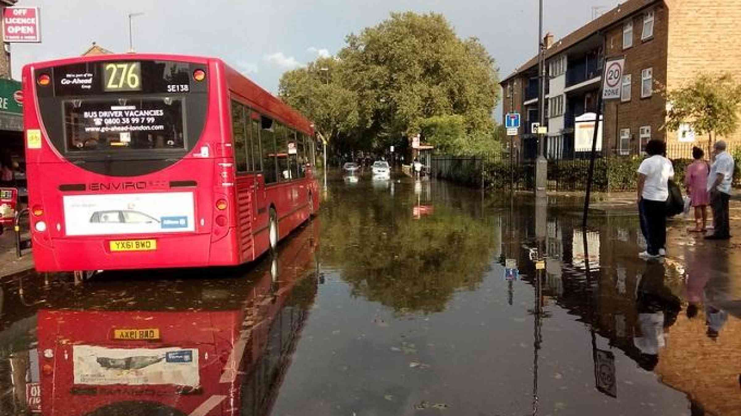
The flooding in northern England was indeed extensive, with about 500 homes flooded and more than 1,000 properties evacuated in Doncaster, and major transport disruption across several counties. Subsequent media coverage did highlight the many ways that flooding can be stopped, but key articles tended to focus on typically capital-intensive solutions: flood walls, river embankments, demountable flood barriers or dredging (the benefits of which are highly debatable). The overarching message was that these events are unpredictable and unprecedented, and the only way to properly deal with them is to invest millions in large physical infrastructure.
While these are helpful suggestions, they only address part of the problem. There is another root cause of flooding that appears not to get so much airtime, namely the role of a fractured planning system that still enables developers to build homes in high flood risk areas.
How planning laws made risky building easy
Urban planning in England is highly regulated and has often been accused of constraining development or in some cases stymieing private sector investments. A 2006 government policy statement attempted to direct development away from areas at highest risk – in simple terms, the intention was to promote building appropriate things in appropriate locations.
However, in 2012, the then coalition government published a new National Planning Policy Framework for England, which replaced existing policy and meant there was no longer clear guidance to prevent building in flood plains. To complicate matters further, the Growth and Infrastructure Act in 2013 released large areas of greenfield land for development. The act effectively gave developers a right to submit major planning applications directly to central government and thus proposals and decisions could evade not only communities but also local planning authorities.
As a result of these legislative changes, there is now a better chance of vulnerable homes being built in flood-prone areas. So how has this policy landscape impacted the number of homes/apartments (typically referred to as “dwellings” in government data) being build in flood risk areas?
More than 300,000 new flood-prone homes
The below table shows numbers of new dwellings built between 1989 and 2016 within areas of high flood risk (technically Flood Zone 3: “floodplains” with a one in 100-year return period and “coastal areas” with a one in 200-year return period). The average proportion of new dwellings built in areas of high flood risk has fluctuated annually between 7% and 11% with some regions such as London, Yorkshire and Humber, and the East Midlands regularly surpassing these averages.
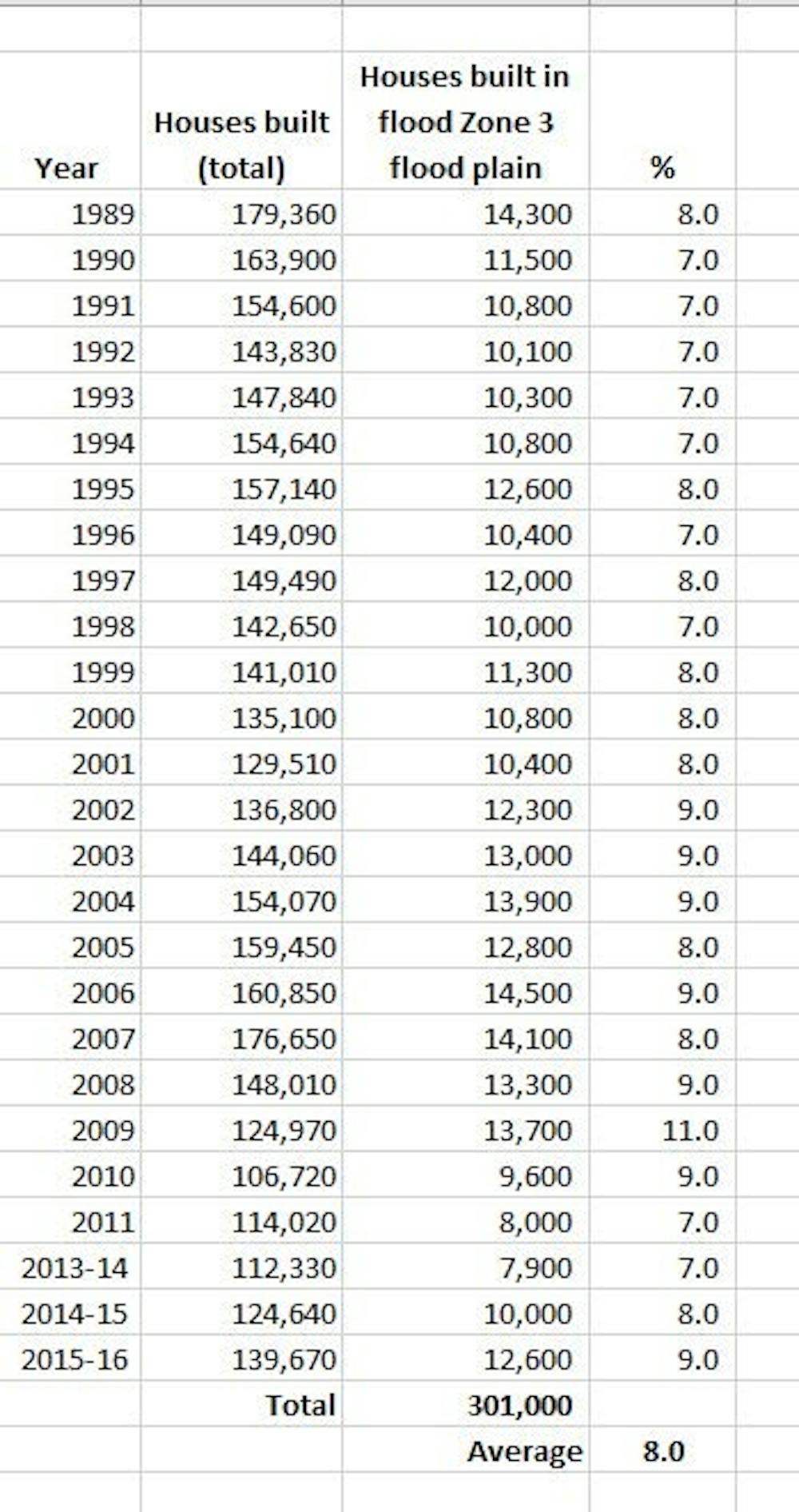
This adds up to more than 300,000 new homes being built since 1989 that are at risk of flooding. Despite a plethora of guidance for planners and apparent restrictions on developers, this building persists.
Over this period, the continued “free-market” development of flood plains in England has had an unexpected effect. Developers have increasingly been using flood plains to build social housing for low income families, homes for the elderly/disabled as well as schools and hospitals. One 2009 study identified 2,374 schools and 89 hospitals in flood prone areas of England. Planning policy has thus caused some of the most vulnerable members of society to occupy highly flood-prone areas.
Urban areas have been creating flood risk. And this is largely due to the government’s focus on making land – low cost, flood prone land – available for development.
Therefore, when considering “extreme” flood events and the highly expensive defence and protection solutions, we should not lose sight of how government policies have consistently created more risk – in England, at least. To see how different things could be, just compare England to Scotland. North of the border, flood policy is controlled separately by the devolved government, which tends to deal with the risk rather better.
![]()