Fly for Humanity by Sky Volunteer to building resilience for Indonesia
Fly for Humanity optimizes the use of Unmanned Aerial Vehicles (UAVs), or drones, in the process of handling disasters to contribute to building resilience for Indonesia.
Description
Geographically, Indonesia is located between the confluence of three major plates which makes Indonesia a country with a high risk of disasters. The Seismicity Map issued by the Indonesian Agency for Meteorological, Climatological and Geophysics shows that in January 2021 alone, 646 tectonic earthquakes were recorded. Other than earthquakes, Indonesia is also susceptible to other natural hazards such as floods, landslides, forest fires, volcanic eruptions and others.
However, in the face of such a huge risk, the management of disasters in Indonesia has not yet fully optimized science and technology, specifically spatial data optimization. With spatial data, we can understand the condition of an area as a whole so that risks and threats of natural hazards can be mapped. One of the technologies for obtaining such spatial data is Unmanned Aerial Vehicle (UAV) technology, better known as drones.
Thus, Synersia Foundation and U-INSPIRE Indonesia has partnered to optimize the use of UAV technology, or drones, through a program titled "Fly for Humanity". The solution offered by the Synersia Foundation is to form Sky Volunteer, a special volunteer team that optimizes the use of Unmanned Aerial Vehicles (UAVs) or drones in the process of handling disasters.
The objectives of this program include reducing disaster risk by providing spatial data using UAVs or drones; supporting the disaster response process (emergency response and recovery) by providing spatial data using UAVs or drones; conducting advocacy on disaster management policies with the support of spatial data; collecting and compiling disaster archives in audiovisual format; and finally, providing training on the use of UAVs or drones for humanitarian and disaster management. Sky Volunteer carries out aerial risk assessments and aerial damage assessments throughout the Indonesian archipelago.
Did the Sendai Framework change or contribute to changes in your activities/organization? If so, how?
The aerial risk and damage assessments conducted by Sky Volunteer (Synersia Foundation) through the Fly for Humanity initiative directly contributes to the the Sendai Framework's priority for action 1, which is understanding disaster risk. These assessments can be used for disaster prevention, mitigation, preparedness and response.
As they are shared with relevant organizations and government bodies, Fly for Humanity's activities also contributes to priority for action 2, which is strengthening disaster risk governance to manage disaster risk.
What led you to make this commitment/initiative?
What was your position before making this Voluntary Commitment / prior to the Sendai Framework?
The Fly for Humanity initiative was first established in 2017 through a collaboration between Synersia Foundation (Sky Volunteer) and U-INSPIRE Indonesia. Since 2018, we have flown our drones all over Indonesia to assess risks prior to disasters and damages post-disasters and we are currently scaling up.
In May 2022, Fly for Humanity participated in the Ignite Stage of the Global Platform for Disaster Risk Reduction that was held in Bali, Indonesia which prompted the submission of this commitment to the Sendai Framework Voluntary Commitments online platform.
Deliverables and Progress report
Deliverables
Deliverables are the end-products of the initiative/commitment, which can include issuance of publications or knowledge products, outcomes of workshops, training programs, videos, links, photographs, etc.
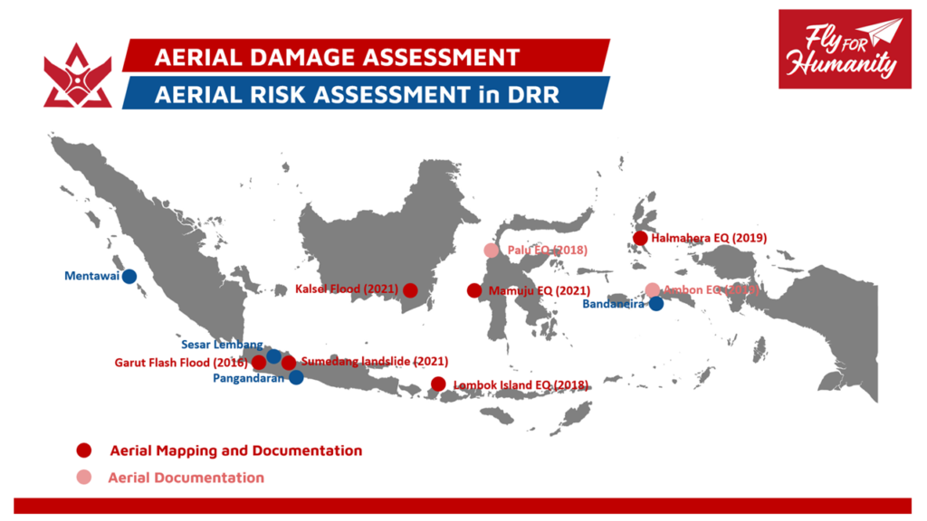
Drones are used to conduct aerial damage assessments allowing to monitor and assess damages incurred post-disaster. These assessments are provided to relevant organizations, local governments and the national government to improve response and recovery measures.
Sky Volunteer has carried out the following Aerial Damage Assessments:
Earthquake Aerial Damage Assessment in Lombok, NTB (2018)
Earthquake Aerial Damage Assessment in South Halmahera, North Maluku (2019)
Earthquake Aerial Damage Assessment in Ambon, Maluku (2019)
Flash Flood Aerial Damage Assessment in Sukabumi, West Java (2020)
Landslide Aerial Damage Assessment in Sumedang Regency, West Java (2021)
Flood Aerial Damage Assessment in Hulu Sungai Tengah Regency, South Kalimantan (2021)
Earthquake Aerial Damage Assessment in Mamuju, West Sulawesi (2021)
Drones are used to conduct aerial risk assessments before a disaster occurs. These assessments are shared with relevant organizations and local governments so that communities can be better prepared for future disasters.
Sky Volunteer has carried out the following Aerial Risk Assessments:
Tsunami Aerial Risk Assessment in Mentawai, West Sumatra (2017-2018)
Earthquake Aerial Risk Assessment in Lembang, West Java (2018-2019)
Tsunami Aerial Risk Assessment along the Southern coast of Java Island (2019)
Earthquake Aerial Risk Assessment in Bandaneira, Maluku (2019)
Organizations and focal points
Implementing Organization(s)
Focal points