Glacial Lake Outburst Flooding
A ‘glacial lake outburst flood’ is a phrase used to describe a sudden release of a significant amount of water retained in a glacial lake, irrespective of the cause (Emmer, 2017).
Primary reference(s)
Emmer, A., 2017. Glacier Retreat and Glacial Lake Outburst Floods (GLOFs). Accessed 16 May 2025.
Annotations
Additional scientific description
The term glacial lake outburst flood (GLOF) is used here to refer to the catastrophic release of a water reservoir that has formed either at the side, in front, within, beneath or on the surface of a glacier. Dam structures that impound the water reservoir may be composed primarily of glacial ice, morainic debris, or bedrock (GAPHAZ, 2017).
GLOFs are characterised by extreme peak discharges, often several times in excess of the maximum discharges of hydrometeorological induced floods, with an exceptional erosion/transport potential. They can therefore turn into flow-type movements, such as GLOF-induced debris flow (Emmer, 2017; UN-SPIDER, no date).
Metrics and numeric limits
Not identified.
Key relevant UN convention / multilateral treaty
Sendai Framework for Disaster Risk Reduction 2015-2030.
Drivers
Key overarching determinants of GLOF susceptibility and the resulting event magnitude are the size of the glacier lake, the outburst mechanism (and related hydrograph), and the characteristics of the downstream torrent (determined by channel inclination and debris availability). Ice-dammed lakes can develop at the margin of an advancing (or surging) glacier, when side -valleys or depressions at the side of the glacier become truncated and blocked. Many such lakes formed in high mountain regions during the Last Glacial Maximum and more recently during and following the Little Ice Age. Over time, as the glaciers retreat, the support of the ice dam is removed, and the lake may drain catastrophically or remain trapped behind lateral moraines of the former glacier (GAPHAZ, 2017; UN-SPIDER, no date). Additionally, as glaciers retreat, the surface areas of glacial lakes increase. Debuttressing effects and landslides, even ice avalanches, are frequent drivers (Cook et al, 2018).
Impacts
Notwithstanding the general considerations on flooding impacts contained in the chapeau, GLOFs impacts are similar to those of flash floods
The effects of flooding on health are extensive and significant, ranging from mortality and injuries resulting from trauma and drowning, to infectious diseases and mental health problems (acute and long-term). While some of these outcomes are relatively easy to track, ascertaining the human impact of floods is still weak. For example, it has been reported that two-thirds of deaths associated with flooding are from drowning, with the other third from physical trauma, heart attacks, electrocution, carbon monoxide poisoning and fire. Often, only immediate traumatic deaths from flooding are recorded (WHO, 2013).
Morbidity associated with floods is usually due to injuries, infections, chemical hazards and mental health effects (acute as well as delayed) (WHO, 2013). Hypothermia may also be a problem, particularly in children, if trapped in floodwaters for lengthy periods (WHO, no date). There may also be an increased risk of respiratory tract infections due to exposure (loss of shelter, exposure to flood waters and rain). Power cuts related to floods may disrupt water treatment and supply plants, thereby increasing the risk of water-borne diseases as well as affecting the proper functioning of health facilities, including cold chain (WHO, no date). Floods can potentially increase the transmission of the following communicable diseases: water-borne diseases (such as typhoid fever, cholera, leptospirosis and hepatitis A) and vector-borne diseases (such as malaria, dengue and dengue haemorrhagic fever, yellow fever, and West Nile Fever) (WHO, no date).
The longer-term health effects associated with a flood are less easily identified. They include effects due to displacement, destruction of homes, delayed recovery and water shortages (WHO, 2013).
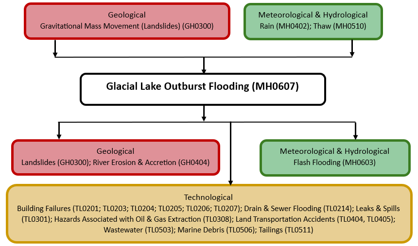
Multi-hazard context
The figure below summarises common interactions between glacial lake outburst flooding and other hazards. This information should be used with caution and not be solely relied upon in Disaster Risk Management, particularly as some interactions may not have been included. Note that hazardous events occurring together or locally in space or time may not necessarily cause, amplify, or be otherwise related to each other. Specific examples of multi-hazard context can be found in the ‘Hazard drivers’ and ‘Impacts’ sections above.
Multi-hazard diagram
Risk Management
Various schemes have been proposed for assessing the susceptibility of glacial lakes to an outburst flood, mostly drawing on remotely sensed information to characterise, semi-quantitatively, the cryospheric environment, lake and dam area, and other geotechnical and geomorphic characteristics of the upstream catchment area of the lake. The potential for unstable rock and/or ice to impact into a lake can be determined using worst-case runout distances. Assessment approaches have mostly been developed and tailored towards regional implementation, especially for moraine- dammed lakes, for which McKillop and Clague (2007) gave a comprehensive overview of many of the relevant susceptibility factors that may condition or trigger an outburst event (GAPHAZ, 2017).
Monitoring
The section above and the table below offer an overview of monitoring glacial lake outburst flooding. This information can be used for forecasting within a national early warning system (EWS). Since EWS capacities and processes differ across countries, the most current and specific information regarding EWS should be obtained from the appropriate national or regional agency/authority responsible for disaster management.
| Which institution(s) produce(s) Disaster Risk Data/Information? |
|
| How is the Hazard Observed/Monitored/Forecast? | Glacial Lake Outburst Floods (GLOFs) are monitored using satellite imagery, drones, and on-the-ground sensors to track glacial lake levels, ice stability, and terrain changes. Scientists analyse temperature trends, rainfall, and seismic activity to assess the risk of sudden lake bursts. Hydrological models simulate potential flood paths, helping forecasters predict downstream impacts. Early warning systems, including water level sensors and community alerts, help protect lives, infrastructure, and ecosystems from sudden glacial floods. |
References
Emmer, A., 2017. Glacier Retreat and Glacial Lake Outburst Floods (GLOFs). Accessed 16 May 2025.
GAPHAZ, 2017. Assessment of Glacier and Permafrost Hazards in Mountain Regions: Technical Guidance Document. Standing Group on Glacier and Permafrost Hazards in Mountains (GAPHAZ). Accessed 15 May 2025.
Cook, K. L., Andermann, C., Gimbert, F., Adhikari, B. R. and Hovius, N., 2018. Glacial lake outburst floods as drivers of fluvial erosion in the Himalaya. Science, 362(6410): 53-57. Accessed 15 May 2025.
McKillop, R.J. and J.J. Clague, 2007. Statistical, remote sensing-based approach for estimating the probability of catastrophic drainage from moraine-dammed lakes in southwestern British Columbia. Global and Planetary Change, 56:153-171.
UN-SPIDER, no date. Knowledge Portal: Glacial Lake Outburst. United Nations Platform for Space-based Information for Disaster Management and Emergency Response (UN-SPIDER). Accessed 16 May 2025.
WHO, no date. Flooding and communicable diseases fact sheet. World Health Organization (WHO). Accessed 16 May 2025.
WHO, 2013. Floods in the WHO European Region: Health effects and their prevention. World Health Organization (WHO), Regional Office for Europe. Accessed 16 May 2025.