Flooding
Flooding is (1) an overflowing by water of the normal confines of a watercourse or other body of water; (2) an accumulation of drainage water over areas which are not normally submerged; (3) a controlled spreading of water for irrigation (WMO and UNESCO, 2012).
Primary reference(s)
WMO and UNESCO, 2012. Definition number 552. International Glossary of Hydrology. WMO-No. 385. World Meteorological Organization (WMO) and United Nations Educational, Scientific and Cultural Organization (UNESCO). Accessed 16 May 2025.
Annotations
Additional scientific description
Whereas floods are defined in hydrology as a "(1) rise, usually brief, in the water level of a stream or water body to a peak from which the water level recedes at a slower rate, (2) relatively high flow as measured by stage height or discharge" (WMO and UNESCO, 2012), flooding represents the hazard associated to with these peaks whenever the water overflows the normal confines of the water body.
Flooding can include:
- Coastal Flood: Coastal flooding occurs from multiple sources, including from storm surges, waves and swell, seiches, riverine and flash floods near the coast, tides, sea-level rise and tsunamis. It is most frequently the result of storm surges and high winds coinciding with high tides. The surge itself is the result of the raising of sea levels due to low atmospheric pressure. In particular conditions, such as major estuaries or confined sea areas, the piling up of water is amplified by a combination of the shallowing of the seabed and retarding of return flow (WMO, 2011; WMO, 2022).
- Estuarine (Coastal) Flood: Estuarine flooding is flooding over and near coastal areas caused by storm surges and high winds coincident with high tides, thereby obstructing the seaward river flow. Estuarine flooding can also occur when riverine flooding causes overflow near the estuary or coastal zone, and in specific cases, can also be caused by tsunamis. (WMO, 2011). Therefore, it is challenging to identify a single driver for estuarine flooding.
- Flash Flood: A flash flood is a flood of short duration with a relatively high peak discharge (WMO, 2021).
- Fluvial (Riverine) Flooding: Overflowing by water of the normal confines of a watercourse or other body of water (WMO, 2012).
- Groundwater Flood: A groundwater flood is the emergence of groundwater at the ground surface away from perennial river channels or the rising of groundwater into man-made ground, under conditions where the 'normal' ranges of groundwater level and groundwater flow are exceeded (BGS, 2010).
- Ice-Jam Flood including Debris: An ice-jam flood including debris is defined as an accumulation of shuga including ice cakes, below ice cover. It is broken ice in a river which causes a narrowing of the river channel, a rise in water level and local floods (WMO, 2012).
- Ponding (Drainage) Flood: A ponding flood is a flood which results from rainwater ponding at or near the point where it falls because it is falling faster than the drainage system (natural or man-made) can carry it away (WMO, 2006).
- Snowmelt Flood: A snowmelt flood is a significant flood rise in a river caused by the melting of snowpack accumulated during the winter (WMO, 2012).
- Surface Water Flooding: Surface water flooding is that part of the rain which remains on the ground surface during rain and either runs off or infiltrates after the rain ends, not including depression storage (WMO, 2012).
- Glacial Lake Outburst Flood: A 'glacial lake outburst flood' is a phrase used to describe a sudden release of a significant amount of water retained in a glacial lake, irrespective of the cause (Emmer, 2017).
Metrics and numeric limits
Key flooding metrics, such as flood depth and flow velocity, are usually combined with other variables, such as flooding arrival time, flooding duration, sediment load, contamination levels, and so on, to determine flood hazard indicators (Maranzoni et al., 2022). However, these indicators and metrics may vary across different types of flooding. For example:
- Coastal Flood: The extent and magnitude of coastal flooding is a function of the elevation inland flood waters penetrate, which is controlled by the topography of the coastal land exposed to flooding and coastal flooding-related drivers (Bell et al., 2017).
- Flash Flood: A flash flood is a flood that begins within 6 hours, and often within 3 hours, of a heavy rainfall (NOAA, no date a).
Key relevant UN convention / multilateral treaty
Sendai Framework for Disaster Risk Reduction 2015-2030.
Drivers
Floods tend to be caused by a number of natural events such as rain from slow- moving or stationary low-pressure areas, thunderstorms, and tropical cyclones. The amount and duration of the rainfall, soil type and saturation, geography and whether it is an urban area can affect the magnitude and impacts of the flooding. Flooding can occur at the place of a heavy rain event or far downstream away from the causal rain event. Flooding can also be caused by other factors such as storm surges, tsunamis, ice jams and glacial lake outbursts, as well as being human influenced through dam bursts, improper land use planning, etc. (Geoscience Australia, no date).
Impacts
More people are impacted by floods than by any other hazard. Year on year floods hit various regions around the world, with developing countries most at risk. Almost 2 million people worldwide live in flooding-prone coastal regions. Floods can carry devastating consequences, causing mortality and significant economic loss and damage, with flash floods being the most dangerous due to their speed and destructive power (UNDRR, no date; WMO, 2025; NOAA, no date b).
Health impacts from floods: The effects of flooding on health are extensive and significant, ranging from mortality and injuries resulting from trauma and drowning to infectious diseases and mental health problems (acute and long-term). While some of these outcomes are relatively easy to track, ascertaining the human impact of floods is still weak. For example, it has been reported that two-thirds of deaths associated with flooding are from drowning, with the other third from physical trauma, heart attacks, electrocution, carbon monoxide poisoning and fire. Often, only immediate traumatic deaths from flooding are recorded (WHO, 2013).
Morbidity associated with floods is usually due to injuries, infections, chemical hazards and mental health effects (acute as well as delayed) (WHO, 2013). Hypothermia may also be a problem, particularly in children, if trapped in floodwaters for lengthy periods (WHO, no date). There may also be an increased risk of respiratory tract infections due to exposure (loss of shelter, exposure to flood waters and rain). Power cuts related to floods may disrupt water treatment and supply plants, thereby increasing the risk of water-borne diseases as well as affecting the proper functioning of health facilities, including cold chain (WHO, no date). Floods can potentially increase the transmission of communicable diseases (WHO, no date).
The longer-term health effects associated with a flood are less easily identified. They include effects due to displacement, destruction of homes, delayed recovery and water shortages (WHO, 2013).
Economic impacts from floods: According to the updated WMO Atlas of Mortality and Economic Losses from Weather, Climate and Water Extremes, between 1970 and 2021 floods were amongst the costliest hazardous events, after tropical cyclones, with US$1.3 trillion in economic losses attributed to floods - 32% of the total reported economic losses from extremes over the 51-year period (WMO, 2022). Flooding can significantly affect local economies, disrupting transportation networks and agricultural activities, and damaging property and infrastructure. In the Midwestern United States in 2019, for example, the event known as “The Great Flood of 2019” affected more than 13 million people across 11 states, primarily impacting areas along the Missouri River. The flood caused approximately US$6.3 billion in damage to property and agriculture, with the prolonged nature of the event disrupting agricultural production and reducing crop planting by millions of acres. Various industries in the region experienced disruptions, with high water levels hindering barge transportation and other shipping routes (Sun et al., 2022).
Multi-hazard context
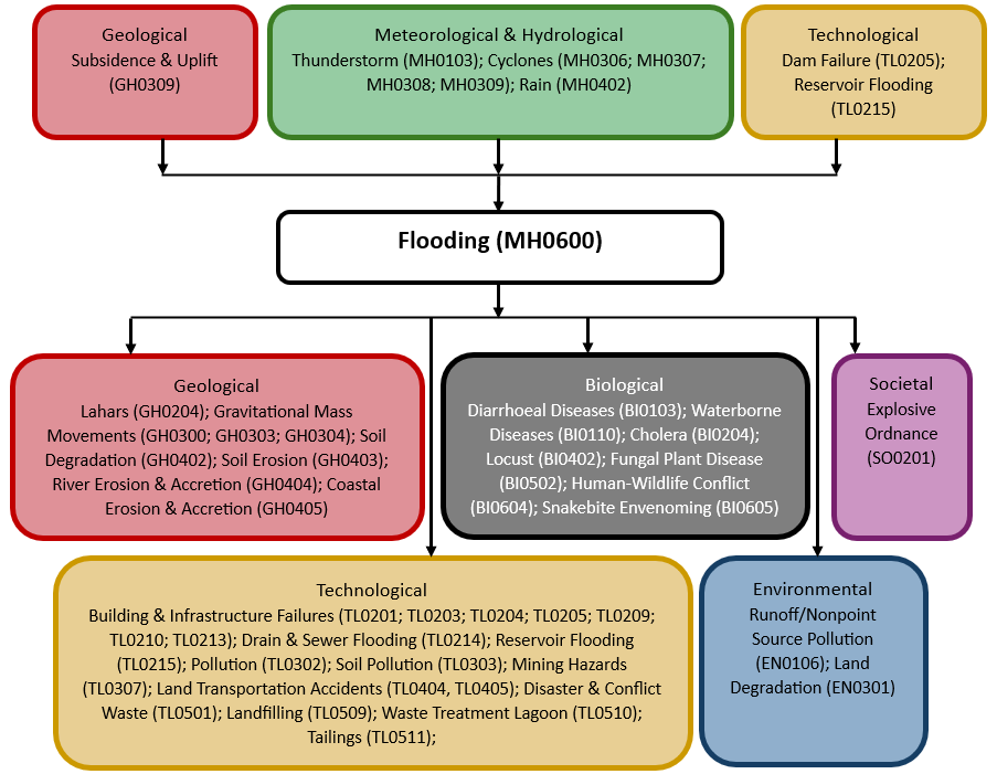
The figure below summarises common interactions between flooding and other hazards. This information should be used with caution and not be solely relied upon in Disaster Risk Management, particularly as some interactions may not have been included. Note that hazardous events occurring together or locally in space or time may not necessarily cause, amplify, or be otherwise related to each other. Specific examples of multi-hazard context can be found in the ‘Hazard drivers’ and ‘Impacts’ sections above.
Multi-hazard diagram
Risk Management
Climate variability and change is giving rise to increasingly frequent and intense flood events, with changes in land use, ecosystem degradation and increased population pressure on flood-prone areas exacerbating flood risk worldwide and aggravating flood-related impacts (UNDRR, no date; WMO, 2025).
Integrated Flood Management (IFM) encourages “an integrated, rather than fragmented, approach to flood management. It integrates land and water resources development in a river basin, within the context of Integrated Resources Management” WMO, 2009.
An example of an initiative promoting an IFM approach is the Associated Programme on Flood Management (APFM), a joint initiative between the World Meteorological Organization (WMO) together with the Global Water Partnership. The APFM “promotes the concept of IFM to maximize net benefits from the use of floodplains and minimize the loss of life and impacts. As such, it provides tools and publications to support flood management” (WMO, 2025).
Aside from risk management, there are several measures that can support flood-related risk reduction:
- “Integrate flood risk assessment into urban planning strategies.
- Avoid building on flood-prone land.
- Develop new building codes to reinforce flood resistance.
- Create more space for rivers, floodplains and wetlands.
- Ensure health of coastal reefs and mangrove plantations.
- Maintain early warning systems, backed up by regular drills and evacuation exercises.
- Have an evacuation plan for those at risk, including the elderly, disabled and very young.
- Catalyse finance and insurance schemes to protect assets and livelihoods.
- Protect and evacuate animals” (UNDRR, no date).
Monitoring
The section above and the table below offer an overview of monitoring flooding. This information can be used for forecasting within a national early warning system (EWS). Since EWS capacities and processes differ across countries, the most current and specific information regarding EWS should be obtained from the appropriate national or regional agency/authority responsible for disaster management.
| Which institution(s) produce(s) Disaster Risk Data/Information? |
|
| How is the Hazard Observed/Monitored/Forecast? | Flooding is monitored using weather radar, rain gauges, river sensors, and satellites that track rainfall, water levels, and soil saturation. Meteorologists and hydrologists analyse these data alongside climate patterns and terrain features to predict when and where floods may occur. Computer models simulate water movement, helping forecasters issue early warnings. By combining real-time observations with historical trends, experts provide alerts that help communities, emergency responders, and planners take action to reduce flood risks and protect lives. |
References
Bell, R., J. Lawrence, S. Stephens, S. Allan, P. Blackett, E. Lemir and D. Zwartz, 2017. Coastal hazards and climate change: New Zealand guidance. pp. 75-81. In: Australasian Coasts and Ports 2017 Conference.
BGS, 2010. Groundwater flooding research overview. British Geological Survey (BGS). Accessed 16 May 2025.
Emmer, A., 2017. Glacier Retreat and Glacial Lake Outburst Floods (GLOFs). Accessed 16 May 2025.
Geoscience Australia, no date. Flood. Accessed 16 May 2025.
Maranzoni, A., D’Oria, M., and Rizzo, C., 2022. Quantitative flood hazard assessment methods: A review. Journal of Flood Risk Management, 16(1). Accessed 16 May 2025.
NOAA, no date a. Flash Flooding Definition. National Oceanic and Atmospheric Administration (NOAA), National Weather Service. Accessed 16 May 2025.
NOAA, no date b. Severe Weather 101: Flood Basics. NOAA National Severe Storms Laboratory. Accessed 16 May 2025.
Sun, Q., Mann, J. and Skidmore, M., 2022. The Impacts of Flooding and Business Activity and Employment: A Spatial Perspective on Small Business. Water Economics and Policy, 8(3), 2140003. Accessed 16 May 2025.
UNDRR, no date. Hazards. Flood. UNDRR Prevention Web. Accessed 16 May 2025.
WMO and UNESCO, 2012. International Glossary of Hydrology. WMO-No. 385. World Meteorological Organization (WMO) and United Nations Educational, Scientific and Cultural Organization (UNESCO). Accessed 16 May 2025.
WMO, 2009. Integrated Flood Management, Concept note. WMO-No.1047. World Meteorological Organization (WMO). Integrated Flood Management Accessed 16 May 2025.
WMO, 2011. Manual on Flood Forecasting and Warning. WMO-No. 1072. World Meteorological Organization (WMO). Accessed 16 May 2025.
WMO, 2017. Regional Association IV – Hurricane Operational Plan for North America, Central America and the Caribbean, WMO-No. 1163. World Meteorological Organization (WMO). Accessed 16 May 2025.
WMO, 2021. Technical Regulations. Volume III: Hydrology, WMO-No. 49. World Meteorological Organization (WMO). Accessed 16 May 2025.
WMO, 2022. Guidelines on Implementation of a Coastal Inundation Forecasting–Early Warning System, WMO-No.1293. World Meteorological Organization (WMO). Accessed 16 May 2025.
World Meteorological Organization, 2022: WMO Atlas of Mortality and Economic Losses from Weather, Climate, and Water Extremes (1970–2019) (WMO-No. 1267) 2022 update.
WMO, 2025: Floods. World Meteorological Organization (WMO). Accessed 16 May 2025.
WHO, no date. Flooding and communicable diseases fact sheet. World Health Organization (WHO). Accessed 16 May 2025.
WHO, 2013. Floods in the WHO European Region: Health effects and their prevention. World Health Organization (WHO), Regional Office for Europe. Accessed 16 May 2025.