
Surface Water Flooding
Surface water flooding is that part of the rain which remains on the ground surface during rain and either runs off or infiltrates after the rain ends, not including depression storage (WMO, 2012).
Primary reference(s)
WMO, 2012. Definition number 1465. International Glossary of Hydrology. WMO-No. 385. World Meteorological Organization (WMO). Accessed 16 May 2025.
Annotations
Additional scientific description
Surface water flooding is caused when the volume of rainwater falling does not drain away through the existing drainage systems or soak into the ground but lies on or flows over the ground instead. This type of flooding is usually short-lived and associated with heavy downpours of rain, thunderstorms etc. (NFU, 2019). The UK Government provides a real time flood information service which is easily accessible (UK Government, no date).
Metrics and numeric limits
Not identified.
Key relevant UN convention / multilateral treaty
Sendai Framework for Disaster Risk Reduction 2015-2030.
Drivers
Floods tend to be caused by a number of natural events such as rain from slow- moving or stationary low-pressure areas, thunderstorms, and tropical cyclones. The amount and duration of the rainfall, soil type and saturation, geography and whether it is an urban area can affect the magnitude and impacts of the flooding. Flooding can occur at the place of a heavy rain event or far downstream away from the causal rain event. Flooding can also be caused by other factors such as storm surges, tsunamis, ice jams, glacial lake outbursts, as well as being human influences such as dam bursts, improper land use planning, etc. (Geoscience Australia, no date).
Impacts
This type of flooding’s impacts are very similar to those of groundwater flooding or ponding. Floods are one of the most common hazards.
The effects of flooding on health are extensive and significant, ranging from mortality and injuries resulting from trauma and drowning to infectious diseases and mental health problems (acute and long- term). While some of these outcomes are relatively easy to track, ascertaining the human impact of floods is still weak. For example, it has been reported that two-thirds of deaths associated with flooding are from drowning, with the other third from physical trauma, heart attacks, electrocution, carbon monoxide poisoning and fire. Often, only immediate traumatic deaths from flooding are recorded (WHO, 2013).
Morbidity associated with floods is usually due to injuries, infections, chemical hazards and mental health effects (acute as well as delayed) (WHO, 2013). Hypothermia may also be a problem, particularly in children, if trapped in floodwaters for lengthy periods (WHO, no date). There may also be an increased risk of respiratory tract infections due to exposure (loss of shelter, exposure to flood waters and rain). Power cuts related to floods may disrupt water treatment and supply plants, thereby increasing the risk of water-borne diseases as well as affecting the proper functioning of health facilities, including cold chain (WHO, no date). Floods can potentially increase the transmission of the following communicable diseases: water-borne diseases (such as typhoid fever, cholera, leptospirosis and hepatitis A) and vector-borne diseases (such as malaria, dengue and dengue haemorrhagic fever, yellow fever, and West Nile fever) (WHO, no date). The longer-term health effects associated with a flood are less easily identified. They include effects due to displacement, destruction of homes, delayed recovery and water shortages (WHO, 2013).
Multi-hazard context
The figure below summarises common interactions between surface water flooding and other hazards. This information should be used with caution and not be solely relied upon in Disaster Risk Management, particularly as some interactions may not have been included. Note that hazardous events occurring together or locally in space or time may not necessarily cause, amplify, or be otherwise related to each other. Specific examples of multi-hazard context can be found in the ‘Hazard drivers’ and ‘Impacts’ sections above.
Multi-hazard diagram
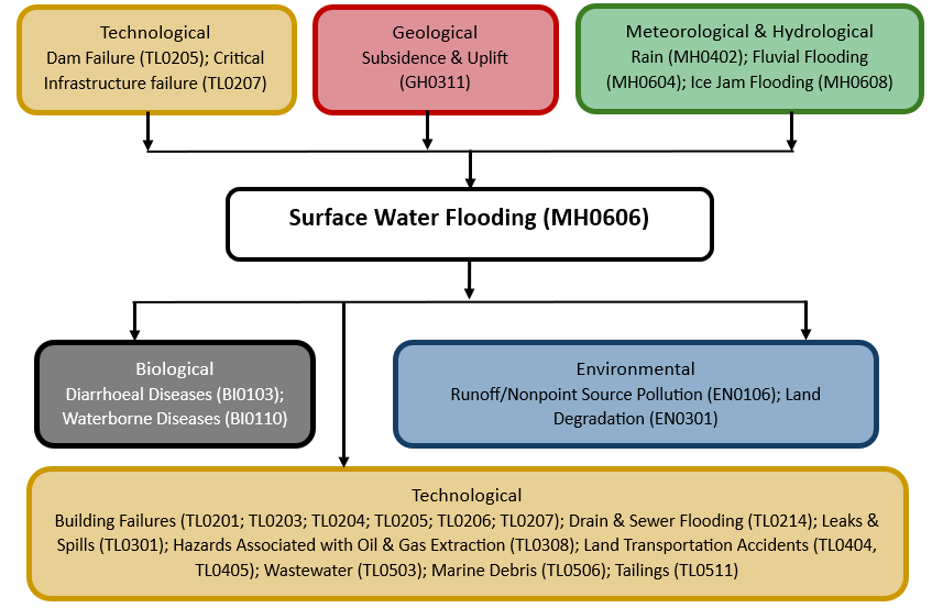
Risk Management
No Information Available
Monitoring
The section above and the table below offer an overview of monitoring surface water flooding. This information can be used for forecasting within a national early warning system (EWS). Since EWS capacities and processes differ across countries, the most current and specific information regarding EWS should be obtained from the appropriate national or regional agency/authority responsible for disaster management.
| Which institution(s) produce(s) Disaster Risk Data/Information? |
|
| How is the Hazard Observed/Monitored/Forecast? | Surface water flooding is monitored using weather radar, rain gauges, and drainage system sensors to track heavy rainfall and water accumulation in streets, fields, and low-lying areas. Hydrologists analyse soil saturation, runoff patterns, and stormwater capacity to predict where flooding might occur. Computer models simulate water flow and drainage performance, helping forecasters issue early warnings. By combining real-time data with historical flood patterns, experts provide alerts that enable cities, infrastructure managers, and communities to prepare for and mitigate surface water flooding. |
References
Geoscience Australia, no date. Flood. Accessed 16 May 2025.
NFU, 2019. Environment Agency (EA) maps show risk from surface water flooding. National Farmers Union (NFU). Accessed 16 May 2025.
UK Government, no date. Flood information service. Accessed 16 May 2025.
WHO, no date. Flooding and communicable diseases fact sheet. World Health Organization (WHO). Accessed 16 May 2025.
WHO, 2013. Floods in the WHO European Region: Health effects and their prevention. World Health Organization (WHO), Regional Office for Europe. Accessed 16 May 2025.