Estuarine (Coastal) Flooding
Estuarine flooding is flooding over and near coastal areas caused by storm surges and high winds coincident with high tides, thereby obstructing the seaward river flow. Estuarine flooding can be caused by tsunamis in specific cases (WMO, 2011).
Primary reference(s)
WMO, 2011. Manual on Flood Forecasting and Warning. WMO-No. 1072. World Meteorological Organization (WMO). Accessed 15 May 2025.
Annotations
Additional scientific description
Estuaries are inlet areas of the coastline where the coastal tide meets a concentrated seaward flow of fresh water in a river. The interaction between the seaward flow of river water and landward flow of saline water during high tides may cause a build-up of water or an inland-moving tidal bore. Frequently, the funnel shape characteristic of many estuaries causes an increase in high water levels in the upper, narrowing reaches of the associated river. These types of floods are mostly experienced in deltaic areas of rivers along the coasts, for example, the mouths of the Ganges. They are more frequent and less severe in terms of inundated depth and area than flooding caused by storm surges (WMO, 2011).
Metrics and numeric limits
Not identified.
Key relevant UN convention / multilateral treaty
Sendai Framework for Disaster Risk Reduction 2015-2030.
Drivers
Storm surges and high winds coinciding with high tides are the most frequent cause of estuarine/coastal flooding. The surge itself is the result of the rising of sea levels due to low atmospheric pressure. In particular configurations, such as major estuaries or confined sea areas, the piling up of water is amplified by a combination of the shallowing of the seabed and retarding of return flow. Major deltas such as the Mississippi and Ganges are prone to this type of flooding when affected by hurricanes (cyclones). Another sensitive area is the southern North Sea in western Europe, owing to particular tracks of winter depressions. If the surge takes place near the mouth of a river issuing into the sea, the river flow will be obstructed due to the surge, resulting in severe flooding over and near the coastal areas. Tsunamis resulting from sub-seabed earthquakes are a very specific cause of occasionally severe coastal flooding (WMO, 2011). Also, estuarine flooding can happen in cases when riverine flooding (i.e. when the river is experiencing a significant freshwater flow) produces an overflow near the estuary/coastal zone. It is therefore difficult, as in the case of coastal flooding, to identify a single driver for estuarine flooding.
Impacts
Floods are one of the most common hazards. The effects of flooding on health are extensive and significant, ranging from mortality and injuries resulting from trauma and drowning to infectious diseases and mental health issues (acute and long- term). While some of these outcomes are relatively easy to track, ascertaining the human impact of floods is still weak. For example, it has been reported that two-thirds of deaths associated with flooding are from drowning, with the other third from physical trauma, heart attacks, electrocution, carbon monoxide poisoning and fire. Often, only immediate traumatic deaths from flooding are recorded (WHO, 2013).
Morbidity associated with floods is usually due to injuries, infections, chemical hazards and mental health effects (acute as well as delayed) (WHO, 2013). Hypothermia may also be a problem, particularly in children, if trapped in floodwaters for lengthy periods (WHO, no date). There may also be an increased risk of respiratory tract infections due to exposure (loss of shelter, exposure to flood waters and rain). Power cuts related to floods may disrupt water treatment and supply plants, thereby increasing the risk of water-borne diseases, as well as the proper functioning of health facilities, including cold chain (WHO, no date). Floods can potentially increase the transmission of the following communicable diseases: water-borne diseases (such as typhoid fever, cholera, leptospirosis and hepatitis A) and vector-borne diseases (such as malaria, dengue and dengue haemorrhagic fever, yellow fever, and West Nile fever) (WHO, no date).
The longer-term health effects associated with a floods and related hazards, such as mould in homes, are less easily identified. They include effects due to displacement, destruction of homes, delayed recovery, and water shortages., (WHO, 2013).
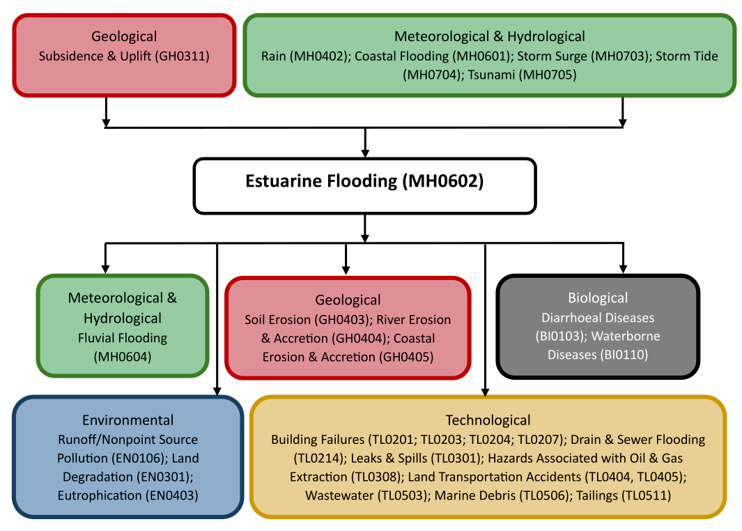
Multi-hazard context
The figure below summarises common interactions between estuarine flooding and other hazards. This information should be used with caution and not be solely relied upon in Disaster Risk Management, particularly as some interactions may not have been included. Note that hazardous events occurring together or locally in space or time may not necessarily cause, amplify, or be otherwise related to each other. Specific examples of multi-hazard context can be found in the ‘Hazard drivers’ and ‘Impacts’ sections above.
Multi-hazard diagram
Risk Management
Effective risk management for estuarine flooding requires integrated approaches that combine structural measures, such as tidal barriers, embankments, and floodgates, with nature-based solutions like wetland restoration and mangrove protection, which buffer surge impacts. Accurate flood modelling, early warning systems, and land-use planning are essential to reduce vulnerability in densely populated estuarine zones. Long-term resilience also depends on adaptive governance frameworks that account for sea-level rise, climate change, and evolving socio-economic pressures. (UK Department of Environment, Food & Rural Affairs and Environment Agency, 2023)
Monitoring
The section above and the table below offer an overview of monitoring estuarine flooding. This information can be used for forecasting within a national early warning system (EWS). Since EWS capacities and processes differ across countries, the most current and specific information regarding EWS should be obtained from the appropriate national or regional agency/authority responsible for disaster management.
| Which institution(s) produce(s) Disaster Risk Data/Information? |
|
| How is the Hazard Observed/Monitored/Forecast? | Estuarine (coastal) flooding is monitored using tide gauges, river flow sensors, satellite imagery, and weather radar to track tidal movements, storm surges, and river discharge. Scientists analyse interactions between sea level, river flow, and extreme weather events to predict flooding risks. Advanced hydrodynamic models simulate how water moves through estuaries, helping forecasters issue advisories and early warnings. By combining real-time data with historical trends, experts provide timely alerts to protect communities, ecosystems, and critical infrastructure from estuarine flooding. |
References
WHO, no date. Flooding and communicable diseases fact sheet. World Health Organization (WHO). Accessed 15 May 2025.
WHO, 2013. Floods in the WHO European Region: Health effects and their prevention. World Health Organization (WHO), Regional Office for Europe. Accessed 15 May 2025.
WMO, 2011. Manual on Flood Forecasting and Warning. WMO-No. 1072. World Meteorological Organization (WMO). Accessed 15 May 2025.
UK Department of Environment, Food & Rural Affairs and Environment Agency, 2023. Managing future flood risk and Thames Barrier: Thames Estuary 2100. London: UK Government. Accessed 15 May 2025.