Coastal Flooding
Coastal flooding occurs from multiple sources, including storm surges, waves and swell, seiches, riverine and flash floods near the coast, tides, sea-level rise and tsunamis. It is most frequently the result of storm surges and high winds coinciding with high tides. The surge itself is the result of the raising of sea levels due to low atmospheric pressure. In particular configurations, such as major estuaries or confined sea areas, the piling up of water is amplified by a combination of the shallowing of the seabed and retarding of return flow (WMO, 2011; WMO, 2022).
Primary reference(s)
WMO, 2011. Manual on Flood Forecasting and Warning. WMO-No. 1072. World Meteorological Organization (WMO). Accessed 15 May 2025.
WMO, 2022. Guidelines on Implementation of a Coastal Inundation Forecasting–Early Warning System, WMO-No.1293. World Meteorological Organization (WMO). Accessed 15 May 2025.
Annotations
Additional scientific description
Major deltas such as the Mississippi and Ganges are prone to coastal flooding when affected by hurricanes (cyclones). Another sensitive area is the southern North Sea in western Europe, as a result of particular tracks of winter depressions. If the surge takes place near the mouth of a river issuing into the sea, the river flow will be obstructed due to the surge, resulting in severe flooding over and near the coastal areas. Tsunamis resulting from sub-seabed earthquakes are a very specific cause of occasionally severe coastal flooding (WMO, 2011).
Coastal flooding is largely a natural event, however, human influence on the coastal environment can exacerbate coastal flooding (Dawson et al., 2009). Extraction of water from groundwater reservoirs in the coastal zone can enhance subsidence of the land, increasing the risk of flooding (Nicholls, 2002).
Seawater can flood the land via several paths:
- Direct flooding: the sea height exceeds the elevation of the land, often where waves have not built up a natural barrier such as a dune system.
- Overtopping of a barrier: the barrier may be natural or human- engineered, and overtopping occurs due to swell conditions during storms or high tides, often on open stretches of the coast. The height of the waves exceeds the height of the barrier, and water flows over the top of the barrier to flood the land behind it. Overtopping can result in high velocity flows that can erode significant amounts of the land surface, which can undermine defence structures (Gallien et al., 2011).
- Breaching of a barrier: the barrier may be natural (sand dune) or human engineered (sea wall), and breaching occurs on open coasts exposed to large waves. Breaching is where the barrier is broken down or destroyed by waves allowing the seawater to extend inland and flood the area.
Metrics and numeric limits
The extent and magnitude of coastal flooding is a function of the elevation inland flood waters penetrate, which is controlled by the topography of the coastal land exposed to flooding; storm surge conditions; and the broader bathymetry of the coastal area (Bell et al., 2017).
Key relevant UN convention / multilateral treaty
United Nations. (1982). United Nations Convention on the Law of the Sea (UNCLOS). Often referred to as the "constitution of the oceans," this convention provides a comprehensive framework for governing ocean space, including provisions to address coastal flooding and protect the marine environment.
Drivers
Flooding constitutes a particular challenge in low-lying areas such as deltas and coastal plains, and land subsidence caused by sediment deficits or ground water extraction can further exacerbate the problem.
Impacts
Coastal flooding can result in considerable economic losses and casualties. Moreover, coastal flooding can result in a wide range of environmental impacts on different spatial and temporal scales. Flooding can destroy coastal habitats such as coastal wetlands and estuaries and can erode dune systems (Hunt and Watkiss, 2011).
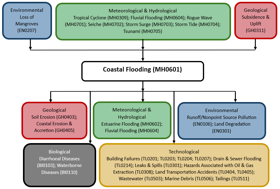
Multi-hazard context
The figure below summarises common interactions between coastal flooding and other hazards. This information should be used with caution and not be solely relied upon in Disaster Risk Management, particularly as some interactions may not have been included. Note that hazardous events occurring together or locally in space or time may not necessarily cause, amplify or be otherwise related to each other. Specific examples of multi-hazard context can be found in the ‘Hazard drivers’ and ‘Impacts’ sections above.
Multi-hazard diagram
Risk Management
The governance structure of coastal zones may be strengthened in different ways (WMO, 2013):
- Promoting better co-operation between different levels and sectors of government, taking into account trends of decentralisation and the need for (national) coordination.
- Facilitating cooperation between the government and the private sector, taking into account trends of privatisation but also the need to safeguard the public interest.
- Better involvement between stakeholders and citizens in development and management issues, to promote societal acceptance of development projects as well the long-term sustainability of development projects (arrangements and incentives for maintenance).
- Creating arrangements for dealing with uncertainties and sharing of risks (insurance).
There are many ways in which humans are trying to prevent the flooding of coastal environments. Technical measures for flood control include dike or seawall or levee construction (hard engineering structures) (Short and Masselink, 1999), maintenance of natural dune systems, protection of coastal ecosystems (natural defence) (Alongi, 2008) and different flood- proofing and accommodation activities. Engineered protection structures along the coast, such as sea walls, if not well planned, can alter the natural processes of the beach, often leading to erosion on adjacent stretches of the coast, which also increases the risk of flooding (Pope, 1997).
Non-structural mechanisms also exist to mitigate coastal flooding: building regulations; coastal hazard zoning; urban development planning; spreading risk through insurance; and enhancing public awareness (Snoussi et al., 2008; Dawson et al., 2011).
Generally, even moderate flooding hazards should be taken very seriously due to the potentially disastrous consequences, and flood protection is a key aspect in coastal disaster risk reduction.
The effects of flooding on health are extensive and significant, ranging from mortality and injuries resulting from trauma and drowning to infectious diseases and mental health issues (acute and long-term). While some of these outcomes are relatively easy to track, ascertaining the human impact of floods is still weak. For example, it has been reported that two-thirds of deaths associated with flooding are from drowning, with the other third from physical trauma, heart attacks, electrocution, carbon monoxide poisoning and fire. Often, only immediate traumatic deaths from flooding are recorded (WHO, 2013).
Morbidity associated with floods is usually due to injuries, infections, chemical hazards and mental health effects (acute as well as delayed) (WHO, 2013). Hypothermia may also be a problem, particularly in children, if trapped in floodwaters for lengthy periods (WHO, no date). There may also be an increased risk of respiratory tract infections due to exposure (loss of shelter, exposure to flood waters and rain). Power cuts related to floods may disrupt water treatment and supply plants, thereby increasing risk of water-borne diseases as well as the proper functioning of health facilities, including cold chain (WHO, no date).
Floods can potentially increase the transmission of the following communicable diseases: water-borne diseases (such as typhoid fever, cholera, leptospirosis and hepatitis A) and vector-borne diseases (such as malaria, dengue and dengue haemorrhagic fever, yellow fever, and West Nile fever) (WHO, no date).
The longer-term health effects associated with a flood are less easily identified. They include effects due to displacement, destruction of homes, delayed recovery and water shortages (WHO, 2013).
Monitoring
The section above and the table below offer an overview of monitoring coastal flooding. This information can be used for forecasting within a national early warning system (EWS). Since EWS capacities and processes differ across countries, the most current and specific information regarding EWS should be obtained from the appropriate national or regional agency/authority responsible for disaster management.
| Which institution(s) produce(s) Disaster Risk Data/Information? |
|
| How is the Hazard Observed/Monitored/Forecast? | Coastal flooding is monitored using tide gauges, satellite observations, and weather radar to track rising sea levels, storm surges, and extreme weather events. Meteorologists, hydrologists, and oceanographers analyse wind speeds, atmospheric pressure, and wave heights to predict potential flooding, while hydrological models simulate how water will move inland. Forecasts combine real-time data with historical trends to provide early warnings, helping communities, emergency responders, and infrastructure planners prepare for and mitigate coastal flooding impacts. |
References
Alongi, D.M., 2008. Mangrove forests: resilience, protection from tsunamis, and responses to global climate change. Estuarine, Coastal and Shelf Science, 76:1-13.
Bell, R., J. Lawrence, S. Stephens, S. Allan, P. Blackett, E. Lemir and D. Zwartz, 2017. Coastal hazards and climate change: New Zealand guidance. pp. 75-81. In: Australasian Coasts and Ports 2017 Conference.
Dawson, R.J., M.E. Dickson, R.J. Nicholls et al., 2009. Integrated analysis of risks of coastal flooding and cliff erosion under scenarios of long term change. Climatic Change, 95:249-288.
Dawson, R.J., T. Ball, J. Werrity, A. Werrity, J.W. Hall and N. Roche, 2011. Assessing the effectiveness of non-structural flood management measures in the Thames Estuary under conditions of socio-economic and environmental change. Global Environ- mental Change, 21:628-646.
Gallien, T.W., J.E. Schubert and B.F. Sanders, 2011. Predicting tidal flooding of urbanized embayments: a modeling framework and data requirements. Coastal Engineering, 58:567-577.
Hunt, A. and P. Watkiss, 2011. Climate change impacts and adaptation in cities: a review of the literature. Climatic Change, 104:13-49.
Nicholls, R.J., 2002. Analysis of global impacts of sea-level rise: a case study of flooding. Physics and Chemistry of the Earth, 27:1455-1466.
Pope, J., 1997. Responding to coastal erosion and flooding damages. Journal of Coastal Research, 13:704-710.
Short, A.D. and G. Masselink, 1999. Embayed and structurally controlled beaches. pp. 230-250. In: Handbook of Beach and Shoreface Morphodynamics.
Snoussi, M., T. Ouchani and S. Niazi, 2008. Vulnerability assessment of the impact of sea-level rise and flooding on the Moroc- can coast: the case of the Mediterranean eastern zone. Estuarine, Coastal and Shelf Science, 77:206-213.
United Nations, 1982. United Nations Convention on the Law of the Sea (UNCLOS). Montego Bay, 10 December 1982. Accessed 15 May 2025.
WHO, no date. Flooding and communicable diseases fact sheet. World Health Organization (WHO). Accessed 15 May 2025.
WHO, 2013. Floods in the WHO European Region: Health effects and their prevention. World Health Organization (WHO), Regional Office for Europe. Accessed 15 May 2025.
WMO, 2011. Manual on flood forecasting and warning, WMO-No. 1072. World Meteorological Organization (WMO). Accessed 15 May 2025.
WHO, 2013. Coastal and Delta Flood Management. Issue No. 17. World Meteorological Organization (WMO). Accessed 15 May 2025.