Virtual reality for flood risk communication: Making rare events tangible

By making rare and complex events easier to visualise, this case study from France shows how tools that combine virtual reality and special effects improve public understanding and dialogue on flood risk.
Flood risk is often difficult to communicate. By nature, extreme flood events are rare, complex and, for many people, hard to imagine.
In France, local water management authorities has been experimenting with virtual reality (VR) and special effects (VFX) to address this challenge — not by replacing traditional tools, but by opening up new ways to start conversations about risk.
Making rare events visible
Matthieu Hervé and Yacine Haddou, both work in local structures whose mission is to manage water resources and flood risk more specifically. Matthieu heads the water management authority of the Yzeron river in the area of Lyon, while Yacine is employed at a public structure responsible for reducing river risk in part of the Bouches-du-Rhône department. They share a common concern.
“One of the main challenges,” Matthieu explains, “is that people tend to underestimate past flood events. When we tell them that water reached a certain point, they often think we are exaggerating.”
In the area where Yacine’s organization operates, the last major river flood occurred in 1993, with only some flooding events recorded since then. Even though the 2019 floods served as a reminder of the area’s vulnerability, many people have come to view flood risk as a distant memory. Yet the threat remains dormant rather than gone, and it could re-emerge with devastating force at any time.
Earlier historical records point to major floods in 1978 and beyond. This gap between lived experience, memory and scientific knowledge makes risk communication difficult.
One long-standing tool is the use of flood markers in public spaces, which physically indicate past water levels on buildings and infrastructure. “These markers are essential because memory fades like paint in the rain,” says Yacine. “They make risk tangible again in the urban landscape.”
However, both professionals felt the need to go further in making risk communication more engaging and accessible. This led to the idea of using Virtual Reality (VR) to visualise flooding in situ, bridging knowledge gaps and making flood scenarios more concrete.
The VR/VFX project
The project was developed with visual effects specialist Pierre Scholl, for whom the project is the culmination of a career-long fascination with stereoscopy—the science of creating depth. Drawing on his background as a geological engineer and his experience with aerial stereoscopic photography used to create flood hazard maps, Pierre sought to push the boundaries of "video game" style graphics.
"My goal was to reach a level of realism where the observer might even doubt if the scene is digital or a memory of a real event," Pierre explains. He believes this visual fidelity is what moves risk from a theoretical probability to a perceived reality.
The project combines two types of visual tools:
- immersive 3D virtual reality simulations experienced through headsets;
- interactive visual comparisons showing flooded and non-flooded scenarios on static images.
These tools offer different perspectives: one provides a “top-down” understanding of flooding, while the other places users directly within the flood environment.
Sites that would be visualised were selected based on their past and current flood risk levels. Each site required extensive coordination with local authorities and property owners, particularly for installing flood markers and enabling public access through QR codes linked to the VR experience.
Effets spéciaux et réalité virtuelle appliqués à la sensibilisation aux risques naturels
An entry point for dialogue
The collaboration between the public structures and Pierre wasn't just a client-contractor relationship; it was a shared mission. Pierre emphasizes that the “courage” of these institutions was the real catalyst. They were willing to pilot a tool that didn't yet exist in the French disaster risk reduction landscape. "I felt like part of their team," says Pierre. "Our shared goal was simple: community awareness and protection."
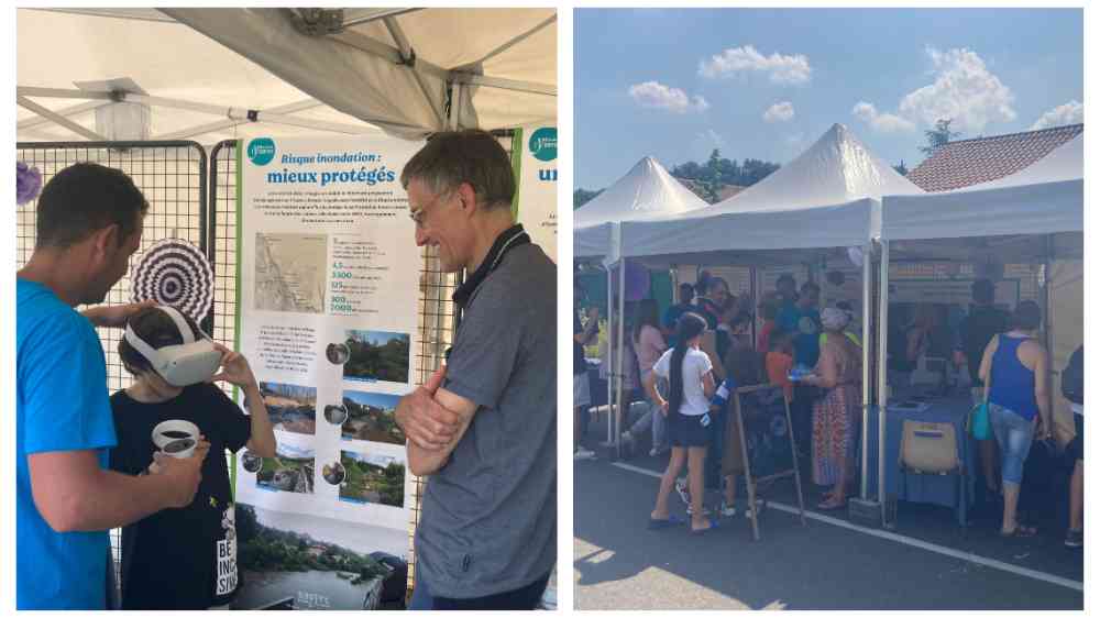
The water management authority headed by Matthieu has been integrating the VR tool into broader public awareness activities, such as community events, guided visits, educational programmes in schools and training and awareness sessions for elected officials.
“When the brain truly sees what a flood would look like in a familiar street, it integrates it as a non-zero probability.”
Pierre Scholl
Menelik, Yacine’s structure, organised a major outreach event bringing residents closer to the river through guided walks, theatre performances and interactive demonstrations. During this event, residents were able to experience immersive flood scenarios using VR headsets, including visualisations of submerged bridges and flood-affected urban areas.
According to Matthieu, the main value of VR is not that it fundamentally changes risk perception — but that it makes conversations easier. “It helps people understand what we are talking about and encourages them to ask questions.”, says Matthieu. The tool also supports more locally-based communication. By showing how specific streets, houses and infrastructure could be affected, it makes the risk directly relevant to local audiences.
“We are not only showing risk, we are allowing people to experience it in a controlled and educational way.”
Yacine Haddou, Menelik
Matthieu explains that VR’s novelty and interactive nature attract visitors — particularly younger audiences — who might otherwise ignore the topic. This creates opportunities to reach wider audiences, including indirectly. For example, children engaging with the technology often bring accompanying adults into the conversation. Furthermore, one of the key advantages of VR, explains Yacine, is its portability. Unlike augmented reality, which was initially considered but deemed technically unfeasible, VR content can be shared in classrooms, public events and online platforms.
Lessons learned
Early feedback from both the public and local decision-makers has been positive. While it is still too early to measure long-term behavioural or policy impacts, the tool has already helped stimulate discussion among elected officials—some of whom have personal memories of past floods in the region.
“It improves how people understand what a major flood event looks like.”
Matthieu Hervé, Yzeron Water Management Authority
For newly elected representatives, Matthieu’s experience shows that VR enables the illustration of what a major flood event could look like and what preparedness might involve. “Seeing the simulation supports the reconnection of collective memory with lived experience,” adds Yacine. In this way, the tool has been integrated into broader discussions about local risk management policies and responsibilities.
The experience also highlights practical constraints. VR demonstrations take time and can limit how many people can be engaged during busy events, while effective communication needs targeted discussions. Looking ahead, expanding coverage to more locations is being considered.
A complementary tool
VR is seen as one tool among many. Its strength lies in making abstract risks more tangible and creating space for dialogue. Indeed, the tool “doesn’t explain the genesis of the floods or how to plan the territory”, says Pierre. All other preparedness tools remain indispensable.
However, as hydrological risks evolve in a changing climate, VR tools may play an increasingly important role in bridging the gap between technical knowledge and public understanding.
Pierre views the high level of realism and depth as vital for "taking the threat seriously." When the human brain processes these 3D volumes, the risk stops being abstract. "It’s about emotion and sensation," Pierre notes. "When the brain truly sees what a flood would look like in a familiar street, it integrates it as a non-zero probability. It changes the potential for future action—whether that’s seeking more information or reacting faster when a real warning is issued."
Ultimately, these experiences highlight how innovation in disaster risk reduction is not only about technology, but also about trust, collaboration and reconnecting communities with the realities of their environment.
Pierre Scholl has worked as an expert in natural hazard risk prevention and communication since 2014. A geological and hydrological engineer who graduated in 2001 with a specialization in natural risk management, Pierre draws on nearly 20 years of experience in the field. He has worked both in France, on behalf of government authorities and local administrations, and internationally for associations and NGOs. His technical assignments cover a wide range of activities, including technical studies, hazard, exposure and risk mapping, post-disaster lessons-learned analyses, prevention programmes and public awareness initiatives. At the same time, Pierre Scholl is an author, producer, director, videographer and photographer, which places him in a unique position to lead awareness-raising projects. He has recently developed numerous communication tools for river basin organizations and is committed to making the most advanced technologies accessible for risk prevention. Pierre Scholl, Natural Hazards and Communication, pioneered the use in France of special effects for flood risk awareness campaigns, as well as their application in virtual reality, stereoscopic and 360° environments. These tools received the Award for Sustainable Risk Culture at the 17th International Forum on Major Risks, held in Arras in 2024.
Yacine Haddou is an engineer specializing in hydrology, hydraulics and flood risk management. A graduate of the National School for Water and Environmental Engineering of Strasbourg (ENGEES), he has worked since 2017 at Menelik, the Public Water Management and Development Agency (EPAGE) responsible for aquatic environment management and flood prevention across several watersheds in the Bouches-du-Rhône department of France. His work focuses primarily on hydraulic modelling, risk analysis and the planning of preventive measures for flooding and runoff events. Within the “Flooding and Runoff” division, he coordinates projects involving local authorities, state agencies and technical partners to strengthen territorial resilience to hydrometeorological hazards. His expertise includes understanding flood dynamics, developing decision-support tools and designing strategies to reduce vulnerability.
Matthieu Hervé is Director of SAGYRC (the Syndicate for the Development and Management of the Yzeron, Ratier and Charbonnières rivers). Together with his team, he works to implement integrated public policies on water management, flood prevention and aquatic biodiversity. Operating within a territory that brings together many stakeholders, SAGYRC develops innovative operational strategies to address these challenges by combining technical expertise, territorial governance and field-based action. In this context, the organization uses digital tools, particularly virtual reality, as a means of raising awareness and improving understanding of local issues among decision-makers and the general public. Matthieu Hervé’s career, rooted in public-sector organizations and supported by extensive experience in water policy and innovation, contributes to SAGYRC’s mission of serving local authorities and communities.