Earthquake
Earthquake is a term used to describe both sudden slip on a fault, and the resulting ground shaking and radiated seismic energy caused by the slip, or by volcanic or magmatic activity, or other sudden stress changes in the Earth (USGS).
Until the arrival of COVID-19, earthquakes were the natural hazard that caused the most deaths per event. EM-DAT figures show that earthquakes claimed more than 720,000 lives between 2000 and 2019. Not included in this future are the over 50,000 deaths in the earthquake that struck Turkey and Syria in February 2023. More than 3 billion people live in regions prone to earthquakes
Most earthquakes are caused by the movement of the earth’s 15 tectonic plates. Geophysicists can identify places where earthquakes are sure to happen, but nobody can predict when an earthquake will happen, or its severity. Seismologists register more than 30,000 tremors every year, but most of these are of low magnitude.
International Day in Memory of the Victims of Earthquakes
Earthquakes are among the deadliest natural hazards. The International day is an opportunity for remembrance and renewed commitment to protecting lives and livelihoods from earthquake disasters.
While technology does not yet exist for reducing earthquake hazards, the risk to buildings, infrastructure and human population can be mitigated by seismic retrofitting of existing buildings, improved compliance with seismic safety building guidelines, and avoidance of building on cliff faces, soft soils or next to an active fault (HIP, 2021). Some success has also been achieved in developing early warning systems, which detect earthquakes close to the source or fault rupture, and trigger warnings to more distant locations, providing seconds to minutes of advance warning (Gasparini et al., 2007).
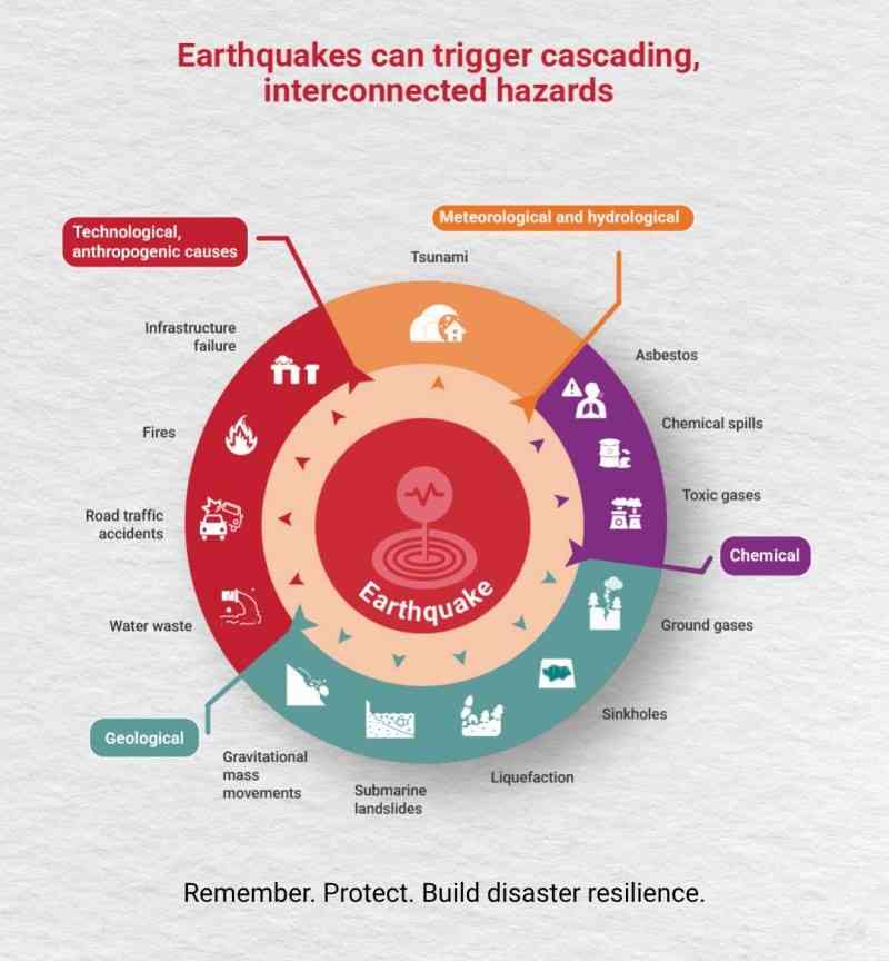
Enlarge image >
Risk factors
Many factors aggravate earthquake risks, including:
- Population density: eight out of the 10 most populated cities in the world are prone to earthquakes.
- Most of the world’s earthquakes occur around the Pacific Rim, in areas where two-thirds of the world’s population lives.
- Poorly built and non-engineered buildings.
- Poverty: constrains more people to live in crowded, substandard housing and unsafe places.
The Scales
One of the ranking systems used to measure earthquake magnitudes is called the Richter Scale. Developed by Charles Richter in 1935, this scale is used to measure earthquake magnitude (ML). It indicates the energy released by an earthquake.
Because of some limitations of all the Richter magnitude scales and its extensions (ML, Mb, and Ms), a new more uniformly applicable extension of the magnitude scale, known as moment magnitude, or Mw, was developed. In particular, for very large earthquakes, moment magnitude gives the most reliable estimate of earthquake size. Moment is a physical quantity proportional to the slip on the fault multiplied by the area of the fault surface that slips; it is related to the total energy released in the earthquake.
Another ranking system, the Modified Mercalli Intensity Scale, measures seismic intensity. The magnitude of an earthquake is a measured value of the earthquake size. The intensity of an earthquake is a measure of the shaking created by the earthquake; this value varies with location.
Richter Scale Categories
| Richter scale | Effect |
| < 3.5 | Generally not felt, but recorded |
| 3.5 - 5.5 | Felt, but rarely causing any damage |
| < 6.0 | Slight damage to well-constructed buildings, heavy damage to poorly constructed buildings |
| 6.1 - 6.9 | May damage inhabited areas up to 100 km wide |
| 7.0 - 7.9 | Major earthquake that may cause serious damage in a very wide area |
| > 8.0 | >Serious earthquake that causes damage hundreds of kilometres away from the epicentre |
| > 9.0 | >Rare great earthquake, major damage in a large region of over 1,000 km |
Risk reduction measures
- Integrating seismic risk into land-use planning and urban development strategies in earthquake-prone zones.
- Ensure that building codes are enforced in critical high-use and high-occupancy infrastructure: hospitals, schools, housing, factories in earthquake zones.
- Warning systems to cut off gas and electricity supplies to reduce fire risk.
- Improving education and awareness through training and preparedness programmes in schools and workplaces on the importance of building safety.