Freezing Rain (Ice storm)
Freezing rain is rain where the temperature of the water droplets is below 0°C. Drops of supercooled rain may freeze on impact with the ground, in-flight aircraft or other objects (WMO, 2017).
Primary reference(s)
WMO, 2017. International Cloud Atlas Manual on the Observation of Clouds and Other Meteors. WMO-No. 407. World Meteorological Organization (WMO). Accessed 25 November 2019.
Annotations
Additional scientific description
Freezing rain or freezing drizzle is precipitation that first falls in liquid form but then descends through a layer of cold air. If this layer is thick enough and the air temperature is below freezing, the precipitation freezes on contact with the ground (or an object that is below freezing temperature), forming a coating of ice on its surface. Driving, and even walking can be dangerous in such conditions. Ice-coated utility lines or poles can be brought down due to the excess weight of the ice.
Freezing rain can sometimes land on surfaces exposed to the air (such as tree limbs) in air temperatures slightly above freezing in strong winds. Local evaporational cooling may result in freezing. Freezing rain frequently occurs, therefore, as a transient condition between the occurrence of rain and ice pellets (sleet). When encountered by an aircraft in flight, freezing rain can cause a dangerous accretion of clear icing (AMS, 2012).
When freezing rain and drizzle cause significant accumulation of ice on objects it is referred to as an Ice storm (WMO, 1992)
Metrics and numeric limits
Ice storms with heavy accumulations of ice can bring down trees and topple utility poles and communication towers. Ice can disrupt communications and power for days while utility companies repair extensive damage. Even small accumulations of ice can be extremely dangerous to motorists and pedestrians. Bridges and overpasses are particularly dangerous because they freeze before other surfaces (AMS, 2012).
Key relevant UN convention / multilateral treaty
Sendai Framework for Disaster Risk Reduction 2015-2030.
Drivers
Freezing rain is a rare type of liquid precipitation that strikes a cold surface and freezes almost instantly. The weight of the ice can sometimes be enough to bring down trees and power lines, and the glaze of ice on the ground (‘black ice’) effectively turns roads and pathways into an ice rink. The freezing rain can also be extremely hazardous for aircraft (UK Met Office, no date).
Impacts
When freezing rain causes heavy accumulations of ice can bring down trees and topple utility poles and communication towers. Ice can disrupt communications and power for days while utility companies repair extensive damage. Even small accumulations of ice can be extremely dangerous to motorists and pedestrians. Bridges and overpasses are particularly dangerous because they freeze before other surfaces (AMS, 2012).
Ice storms can have a very significant impact. The impact of the 1998 ice storm in Canada and the United States illustrates this.
Late on 4 January 1998 freezing rain began to fall on eastern Ontario, southwestern Quebec, and southern New Brunswick and Nova Scotia, Canada. This continued for six days, ending on 10 January. These areas were pelted with 80 mm or more of freezing rain and the event doubled the amount of precipitation experienced in any prior ice storm. The result was a catastrophe that produced the largest estimated insured loss (CAD 1.44 billion) in the history of Canada (Lecomte et al., 1998).
The storm slashed across northern New York and parts of Vermont, New Hampshire and Maine in the United States, leaving a vast trail of damage and destruction (approximately USD 200 million in insured losses). Nevertheless, the damage in the United States paled in contrast to that sustained in Canada (Lecomte et al., 1998).
The combined Canadian and United States insured loss stands in excess of USD 1.2 billion or CAD 1.75 billion, as of 1 October 1998 (Lecomte et al., 1998). In Canada, 28 deaths were attributed to the storm; in the United States, 17 people lost their lives (Lecomte et al., 1998).
According to Emergency Preparedness Canada, electrical outages in the affected areas of Canada deprived 4.7 million people or 16% of the Canadian population of power. In the United States, 546,000 people were without electricity. Thus, in both countries over 5 million people were without power (heat, light and in many instances, water) in the cold of mid-winter, which intensified the human suffering (Lecomte et al., 1998).
Multi-hazard context
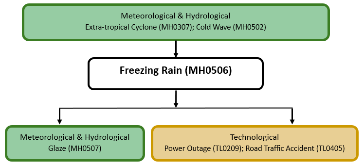
The figure below summarises common interactions between freezing rain and other hazards. This information should be used with caution and not be solely relied upon in Disaster Risk Management, particularly as some interactions may not have been included. Note that hazardous events occurring together or locally in space or time may not necessarily cause, amplify, or be otherwise related to each other. Specific examples of multi-hazard context can be found in the ‘Hazard drivers’ and ‘Impacts’ sections above.
Multi-hazard diagram
Risk Management
In terms of national alerting thresholds, Canada issues a freezing rain warning when freezing rain is expected to pose a hazard to transportation or property, or when freezing rain is expected for at least two hours (in some provinces four hours) (Environment Canada, no date). A winter weather watch is issued in the USA when any accretion of freezing rain or freezing drizzle on road surfaces is observed. A winter storm warning is issued when a half inch (1.3 cm) or greater accretion of freezing rain is expected (NOAA, no date).
Monitoring
The section above and the table below offer an overview of monitoring freezing rain. This information can be used for forecasting within a national early warning system (EWS). Since EWS capacities and processes differ across countries, the most current and specific information regarding EWS should be obtained from the appropriate national or regional agency/authority responsible for disaster management.
| Which institution(s) produce(s) Disaster Risk Data/Information? |
|
| How is the Hazard Observed/Monitored/Forecast? | Freezing rain and ice storms are monitored using weather radar, satellites, and ground-based sensors to track precipitation type, air temperature, and surface conditions. Meteorologists analyse temperature inversions, wind patterns, and humidity levels to predict when rain will freeze upon contact with the ground. Advanced computer models forecast freezing rain and ice accumulation, helping forecasters issue early warnings. These alerts assist transportation agencies, utility providers, and emergency responders in preparing for hazardous roads, power outages, tree and infrastructure damage caused by ice buildup. |
References
AMS, 2012. Glossary of Meteorology: Freezing rain. American Meteorological Society (AMS). Accessed 16 May 2025.
Coburn J., Barthelemie, R., J., Pryor, S. C., 2024. Quantifying the compound hazard of freezing rain and wind gusts across CONUS. Environ. Res. Lett. 19 044016, 10.1088/1748-9326/ad30a4. Accessed 16 May 2025.
Lecomte, E.L., A.W. Pang and J.W. Russell, 1998. ICE STORM ’98. ICLR Research Paper Series – No.1. Accessed 16 May 2025.
NOAA, no date. Warning Criteria. National Weather Service, National Oceanic and Atmospheric Administration (NOAA). Accessed 16 May 2025.
UK Met Office, no date. Freezing rain. Accessed 16 May 2025.
WMO, 1992. International Meteorological Vocabulary. World Meteorological Organization (WMO). Accessed 16 May 2025.
Environment and Climate Change Canada, 2019. Winter Hazards. Accessed 27 November 2019.