Blizzard
A blizzard is a severe snowstorm characterised by poor visibility, usually occurring at high latitudes and in mountainous regions (WMO, 1992).
Primary reference(s)
WMO, 1992. International Meteorological Vocabulary,No. 182. World Meteorological Organization (WMO). Accessed 16 May 2025.
Annotations
Additional scientific description
The term blizzard is generally used in North America and Great Britain. There are differing thresholds for defining and issuing warnings for blizzards.
Metrics and numeric limits
Thresholds for defining and issuing warnings for blizzards vary by country.
In the USA, a blizzard warning is issued for winter storms with sustained or frequent winds of 35 mph (56 km/hr) or higher, with considerable falling and/or blowing snow that frequently reduces visibility to 1/4 of a mile (0.4 km) or less. These conditions are expected to prevail for a minimum of 3 hours (Eye on the Sky, no date).
In the UK, a blizzard is defined as moderate or heavy falling snow (either continuous or in the form of frequent showers) with winds speeds of 30 mph (48 km/hr) or more and a reasonably extensive snow cover reducing visibility to 200 metres (0.13 miles) or less (UK Met Office, 2019).
In Canada, alerting parameters for issuing a blizzard warning include when winds of 40 km/hr or more are expected to cause widespread reductions in visibility to 400 metres (0.25 miles) or less, due to blowing snow, or blowing snow in combination with falling snow, for at least 4 hours. North of the tree line, the thresholds are the same as the national thresholds, except when conditions are expected to last for at least 6 hours (Government of Canada, no date).
Key relevant UN convention / multilateral treaty
Sendai Framework for Disaster Risk Reduction 2015-2030.
Drivers
Blizzard occurs when snow and wind occur simultaneously.
Impacts
A blizzard is severe winter weather characterised by strong winds, and heavy or blowing snow that causes low to zero visibility, with significant social and economic impacts:
Health and safety impacts: Winter storms create a higher risk of car accidents, hypothermia, frostbite, carbon monoxide poisoning, and heart attacks from overexertion, etc. In whiteout conditions associated with blizzards, people have become lost even when going only short distances. To avoid these risks, the warnings and preventative instructions from local and national authorities should be followed.
Travel disruptions: Due to the reduced visibility and strong winds associated with blizzards, blizzards and snowstorms carry significant transportation challenges, causing poor road conditions, flight cancellations and train service suspensions.
Power outages: Heavy snow alongside the accumulation of ice can increase the weight on power lines, causing power line damage and, in turn, power outages.
Impacts on businesses: Blizzards and snowstorms may cause operational slowdowns, and in some cases, complete business closures, resulting in financial losses for affected businesses (Bureau of Meteorology, 2023).
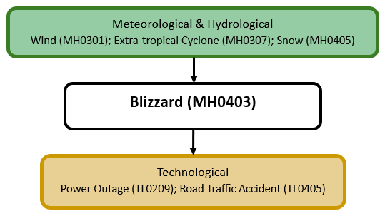
Multi-hazard context
The figure below summarises common interactions between blizzards and other hazards. This information should be used with caution and not be solely relied upon in Disaster Risk Management, particularly as some interactions may not have been included. Note that hazardous events occurring together or locally in space or time may not necessarily cause, amplify, or be otherwise related to each other. Specific examples of multi-hazard context can be found in the ‘Hazard drivers’ and ‘Impacts’ sections above.
Multi-hazard diagram
Risk Management
No Information Available
Monitoring
The section above and the table below offer an overview of monitoring blizzards. This information can be used for forecasting within a national early warning system (EWS). Since EWS capacities and processes differ across countries, the most current and specific information regarding EWS should be obtained from the appropriate national or regional agency/authority responsible for disaster management.
| Which institution(s) produce(s) Disaster Risk Data/Information? |
|
| How is the Hazard Observed/Monitored/Forecast? | Blizzards are observed and monitored using satellites, weather radar, and ground-based sensors to track snowfall intensity, wind speeds, and temperature drops. Meteorologists analyse atmospheric pressure systems, jet stream patterns, and moisture levels to predict storm development. Advanced computer models simulate storm movement and severity, helping forecasters issue early warnings. These alerts assist communities, emergency responders, and transportation authorities in preparing for dangerous conditions, power outages, and travel disruptions. |
References
Bureau of Meteorology, 2023. The Science of Snowstorms and Blizzards. Accessed 13 Mar 2026.
Eye on the Sky, no date. Glossary of Weather Terms: Blizzard Warning. Accessed 16 May 2025.
Government of Canada, no date. Alerting parameters Environment Canada uses for issuing a blizzard warning. Accessed 16 May 2025.
UK Met Office, 2019. Blizzards and Snow Drift. Accessed 16 May 2025.