Sub-Tropical Cyclone
A subtropical cyclone is a non-frontal, low-pressure system that has characteristics of both tropical and extra-tropical cyclones. Like tropical cyclones, they are non-frontal, synoptic-scale cyclones that originate over tropical or subtropical waters and have a closed surface wind circulation about a well-defined centre (WMO, 2024 a).
Primary reference(s)
WMO, 2024 a. Regional Association IV - Hurricane Operational Plan for North America, Central America and the Caribbean. Tropical Cyclone Programme, Report No. TCP-30, World Meteorological Organization (WMO). Regional Association IV - Hurricane Operational Plan. Accessed 03 February 2025.
Annotations
Additional scientific description
A subtropical cyclone is a non-frontal, low- pressure system developing over tropical or subtropical waters which initially contains few tropical characteristics. With time, the subtropical cyclone can become a tropical cyclone (WMO, 2024 b).
Subtropical cyclones have organiszed moderate to deep convection but lack a central dense overcast. Unlike tropical cyclones, subtropical cyclones derive a significant proportion of their energy from baroclinic sources and are generally cold-core in the upper troposphere, often being associated with an upper-level low or trough. In comparison to tropical cyclones, these systems generally have a radius of maximum winds occurring relatively far from the centre (usually greater than 60 nautical miles) and generally have a less symmetric wind field and distribution of convection (WMO, 2024 a; NOAA, 2019).
Subtropical storm: A subtropical storm is a subtropical cyclone in which the maximum sustained surface wind speed (using the U.S. 1-minute average) is 34 kt (39 mph or 63 km/hr) or more (NOAA, 2019).
Subtropical depression: A subtropical cyclone in which the maximum sustained surface wind speed (using the U.S. 1-minute average) is 33 kt (38 mph or 62 km/hr) or less (NOAA, 2019).
Metrics and numeric limits
Not applicable.
Key relevant UN convention / multilateral treaty
Sendai Framework for Disaster Risk Reduction 2015-2030.
Drivers
No Information Available.
Impacts
Cyclones, including tropical and subtropical cyclones, can have far-reaching impacts, particularly in low-lying coastal areas located in the direct path of the storm. The severity of these impacts depends on the cyclone's size, intensity, and the combination of hazards such as wind speed, rainfall, storm surges, and flooding. While winds can cause significant damage, it is often the rainfall and storm surges that lead to catastrophic effects like flooding and landslides, especially in coastal and mountainous regions. Flooding can occur well ahead of landfall and persist long after, continuing to pose a risk to both lives and infrastructure, especially in densely populated or low-lying areas (UNDAC, 2024). These conditions can devastate infrastructure, disrupt communication lines, damage power grids, and result in significant casualties (UNDAC, 2024).
The health impacts of cyclones can be both direct and indirect, increasing the risk of drowning, physical trauma, and the spread of water- and vector-borne diseases. Floodwaters often carry sewage, chemicals, and sharp debris, which can cause injuries, diseases, and electrocution. Additionally, the disruption of public health systems during and after the cyclone limits access to essential healthcare services. Aside from physical health risks, mental health is significantly impacted, as many individuals experience stress, trauma, and anxiety in the aftermath of such disasters. Cyclone-related damage to basic infrastructure like food and water supplies and safe shelter only exacerbates these issues, increasing the risk of food insecurity and long-term health challenges (WHO, 2025; UNDAC, 2024).
The socio-economic consequences of cyclones are equally severe, as these events can cause long-term economic losses by destroying businesses, farms, and fisheries, resulting in income loss for affected families. The destruction of crops, livestock, and fisheries, along with flooding and saltwater intrusion, leads to immediate food shortages and long-term disruptions in the food supply chain. These impacts further undermine public health by increasing malnutrition and decreasing food security. Recovery is often slow, as repeated cyclones can compromise agricultural land, making it harder for communities to rebuild their food stocks and livelihoods (UNDAC, 2024).
Subtropical cyclones, exhibiting both tropical and extra-tropical characteristics, present unique challenges for early warning systems (EWS). Their hybrid nature can lead to rapid intensification and unpredictable paths, complicating accurate forecasting. To address these challenges, advanced numerical weather prediction models, satellite observations, and Doppler radar are employed to monitor their development. National Meteorological and Hydrological Services (NMHSs) play a pivotal role in issuing timely warnings based on real-time data, ensuring that vulnerable populations receive prompt alerts. An effective EWS comprises four key elements: disaster risk knowledge, detection, monitoring, analysis and forecasting, warning dissemination and communication, and preparedness and response capabilities. Integrated EWS frameworks that encompass these elements are essential to mitigate potential damages, particularly in coastal regions prone to high winds, heavy rainfall, and flooding from subtropical storms (WMO, 2025).
Multi-hazard context
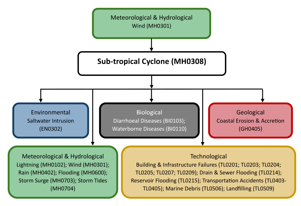
The figure below summarises common interactions between subtropical cyclones and other hazards. This information should be used with caution and not be solely relied upon in Disaster Risk Management, particularly as some interactions may not have been included. Note that hazardous events occurring together or locally in space or time may not necessarily cause, amplify, or be otherwise related to each other. Specific examples of multi-hazard context can be found in the ‘Hazard drivers’ and ‘Impacts’ sections above.
Multi-hazard diagram
Risk Management
Tropical Cyclone Operational Plans are updated on an annual basis, and therefore definitions within the Operational Plans are subject to possible revision (available here: https://community.wmo.int/en/tropical-cyclone-operational-plans).
Monitoring
The section above and the table below offer an overview of monitoring subtropical cyclones. This information can be used for forecasting within a national early warning system (EWS). Since EWS capacities and processes differ across countries, the most current and specific information regarding EWS should be obtained from the appropriate national or regional agency/authority responsible for disaster management.
| Which institution(s) produce(s) Disaster Risk Data/Information? |
|
| How is the Hazard Observed/Monitored/Forecast? | Subtropical cyclones are monitored using satellites, weather radar, specialiszed scientific aircraft, and ocean buoys to track wind speeds, air pressure, and storm movement. Meteorologists analyse sea surface temperatures, atmospheric instability, and jet stream interactions to predict storm development. Advanced computer models simulate storm paths and intensity, helping forecasters issue early warnings. These alerts assist coastal communities, emergency responders, and maritime industries in preparing for heavy rain, strong winds, and potential flooding. |
References
National Hurricane Center (NHC) and Central Pacific Hurricane Center, National Oceanic and Atmospheric Administration (NOAA), 2019. Glossary of NHC Terms. Accessed 16 May 2025.
United Nations Disaster Assessment and Coordination (UNDAC), 2024. UNDAC Handbook – 8th Edition: Hazard Impact Summaries. Accessed 16 May 2025.
World Health Organization (WHO), 2025. Tropical Cyclones: Impact. Accessed 16 May 2025.
World Meteorological Organization (WMO), 2024a. Regional Association IV – Hurricane Operational Plan for North America, Central America and the Caribbean. Tropical Cyclone Programme, Report No. TCP-30. Accessed 16 May 2025.
World Meteorological Organization (WMO), 2024b. Regional Association V – Tropical Cyclone Operational Plan for the South Pacific and South-East Indian Ocean. Tropical Cyclone Programme, Report No. TCP-24, WMO-No. 1181. [online] Available at: https://community.wmo.int/en/tropical-cyclone-operational-plans [Accessed 16 May 2025].
World Meteorological Organization (WMO), 2025. Early Warning System. Accessed 16 May 2025.