Wind
Wind is air motion relative to the Earth’s surface. Unless otherwise specified, only the horizontal component is considered (WMO, 1992).
Primary reference(s)
WMO, 1992. International Meteorological Vocabulary, WMO-No. 182. 2nd Edition. World Meteorological Organization (WMO). Accessed 16 May 2025.
Annotations
Additional scientific description
Wind velocity is an important consideration in relation to, for example, airborne pollution and the landing of aircraft (WMO, 2018). Surface wind is considered mainly as a two-dimensional vector quantity specified by two numbers representing direction and speed (WMO, 2018).
The extent to which wind is characterised by rapid fluctuations is referred to as gustiness, and single fluctuations are called gusts (WMO, 2018).
Metrics and numeric limits
An internationally recognised scale for measuring wind is the Beaufort Scale, which is an empirical measure that relates wind speed to observed conditions at sea or on land. Its full name is the Beaufort wind force scale (Royal Meteorological Society, 2018).
The Beaufort wind force scale has 13 levels, including: calm, light air, light breeze, gentle breeze, moderate breeze, fresh breeze, strong breeze, near gale, gale, strong gale, storm, violent storm, and hurricane. Of note, the quoted wind speed is that measured at 10 m above ground, not at the surface (which, at 2 m, may be only 50-70% of these values (Royal Meteorological Society, 2018).
Key relevant UN convention / multilateral treaty
Sendai Framework for Disaster Risk Reduction 2015-2030.
Drivers
Earth’s orbit around the sun and its rotation on a tilted axis causes some parts of Earth to receive more solar radiation than others. This uneven heating produces global circulation patterns. For example, the abundance of energy reaching the equator produces hot, humid air that rises high into the atmosphere. A low-pressure area forms at the surface, and a region of clouds forms at altitude. The air eventually stops rising and spreads north and south towards the Earth's poles. About 2000 miles (3200 km) from the equator, the air falls back to Earth's surface, blowing towards the pole and back to the equator. Six of these large convection currents cover the Earth from pole to pole. (NOAA, 2024).
Impacts
Wind is a main or contributing component to a number of hazards such as derecho, tropical cyclone, blizzard, sub-tropical cyclone, subtropical storm, tornado, and tropical storm. Wind is also associated with the dispersal of dust storms, volcanic ash and coastal floods.
Human health can be severely affected by windstorms (Goldman et al., 2014). Effects include direct effects, which occur during the impact phase of a storm, causing death and injury due to the force of the wind. Becoming airborne, being struck by flying debris or falling trees and road traffic accidents are the main dangers. Indirect effects, occurring during the pre- and post- impact phases of the storm, include falls, lacerations and puncture wounds, and occur when preparing for, or cleaning up after a storm. Power outages are a key issue and can lead to electrocution, fires and burns, and carbon monoxide (CH0302) poisoning from gasoline- powered electrical generators. Worsening of chronic illnesses due to lack of access to medical care or medication can also occur. Other health impacts include infections and insect bites.
Multi-hazard context
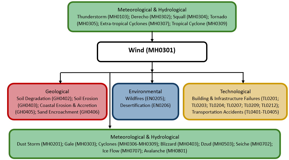
The figure below summarises common interactions between wind and other hazards. This information should be used with caution and not be solely relied upon in Disaster Risk Management, particularly as some interactions may not have been included. Note that hazardous events occurring together or locally in space or time may not necessarily cause, amplify, or be otherwise related to each other. Specific examples of multi-hazard context can be found in the ‘Hazard drivers’ and ‘Impacts’ sections above.
Multi-hazard diagram
Risk Management
Building codes to ensure buildings are resilient to strong winds are implemented in some countries.
Monitoring
The section above and the table below offer an overview of monitoring wind. This information can be used for forecasting within a national early warning system (EWS). Since EWS capacities and processes differ across countries, the most current and specific information regarding EWS should be obtained from the appropriate national or regional agency/authority responsible for disaster management.
| Which institution(s) produce(s) Disaster Risk Data/Information? |
|
| How is the Hazard Observed/Monitored/Forecast? | Winds are monitored using weather stations and satellites to measure wind speed, direction, and atmospheric pressure changes. Meteorologists analyse pressure systems, jet streams, and storm patterns to predict wind velocity and direction. Advanced weather models forecast extreme wind conditions, helping forecasters issue early warnings. These warnings assist aviation, maritime industries, emergency responders, and communities in preparing for strong winds, storms, and potential damage. |
References
Goldman, A., Eggen, B., Golding, B. and Murray, V., 2014. The health impacts of windstorms: a systematic literature review. Public Health, 128, pp.3–28.
National Oceanic and Atmospheric Administration (NOAA), 2024. Weather Systems and Patterns. Accessed 16 May 2025.
Royal Meteorological Society, 2018. The Beaufort Scale: How is wind speed measured?. Accessed 16 May 2025.
World Meteorological Organization (WMO), 2018. Guide to Instruments and Methods of Observation. Volume I – Measurement of Meteorological Variables. WMO No.8. World Meteorological Association (WMO). Accessed 16 May 2025.