Smoke
Smoke is a suspension in the air of small particles produced by combustion (WMO, 2017).
Primary reference(s)
WMO, 2017. Smoke. International Cloud Atlas, World Meteorological Organization (WMO). Accessed 16 May 2025.
Annotations
Additional scientific description
This lithometeor may be present either near the Earth's surface or in the free atmosphere. Viewed through smoke, the Sun appears very red at sunrise and sunset and shows an orange tinge when high in the sky. Smoke from relatively near cities may be brown, dark grey or black. Smoke in extensive layers originating from fairly near forest fires, scatters the sunlight and gives the sky a greenish-yellow hue. Evenly distributed smoke from very distant sources generally has a light greyish or bluish hue. When smoke is present in large quantities, it may be distinguished by its smell (WMO, 2017).
When the lithometeor 'smoke' is present in the free atmosphere, it is typically distinguished from clouds of smoke (clouds from fires or resulting from industry) by its diffuse appearance and by the absence of any discernible outlines (WMO, 2017).
Air quality is also compromised by natural contaminants such as aeroallergens (pollen, moulds), smoke from wildfires, airborne sand and dust, as well as by personal behaviour such as tobacco smoke exposure or indoor burning of solid fuels. When inhaled, these contaminants penetrate deeply into the respiratory system and may initiate a range of damaging biological reactions in the human body (WMO, 2014). As a result, air pollution is now one of the world's greatest environmental health risks.
Metrics and numeric limits
Not available.
Key relevant UN convention / multilateral treaty
Sendai Framework for Disaster Risk Reduction 2015-2030.
Drivers
Smoke results from fires.
Impacts
Smoke contains particulate matter, which is a common proxy for air pollution. The major components of atmospheric particulates are sulphates, nitrates, ammonia, sodium chloride, black carbon, mineral dust and water. It consists of a complex mixture of solid and liquid particles of organic and inorganic substances suspended in the air. While particles with a diameter of 10 microns or less (≤ PM10) can penetrate and lodge deep inside the lungs, the even more health-damaging particles are those with a diameter of 2.5 microns or less (≤ PM2.5). The latter can penetrate the lung barrier and enter the blood system. Chronic exposure to particles contributes to the risk of developing cardiovascular and respiratory diseases, as well as lung cancer (see HIPs on carcinogens CH0200) (WHO, 2018).
Small particulate pollution has health impacts even at very low concentrations, – and no threshold has been identified below which no damage to health is observed. Therefore, the WHO 2005 guideline limits aim to achieve the lowest concentrations of particulate matter possible (WHO, 2018).
Multi-hazard context
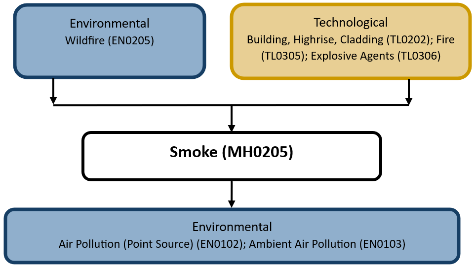
The figure below summarises common interactions between smoke and other hazards. This information should be used with caution and not be solely relied upon in Disaster Risk Management, particularly as some interactions may not have been included. Note that hazardous events occurring together or locally in space or time may not necessarily cause, amplify, or be otherwise related to each other. Specific examples of multi-hazard context can be found in the ‘Hazard drivers’ and ‘Impacts’ sections above.
Multi-hazard diagram
Risk Management
The World Meteorological Organization (WMO) has responded to urgent requests for assistance from Members in several impacted regions by initiating a Vegetation Fire and Smoke Pollution Warning and Advisory System (VFSP-WAS) (WMO, 2019). This provides guidance for addressing both fire and smoke hazards and proposes to support the potential foundation of regional centres to address air quality and the impact of smoke.
The Southeast Pacific, one of the regions most affected by vegetation fires and smoke pollution, has established the first Regional Vegetation Fire and Smoke Pollution Warning and Advisory Centre, operated by the Meteorological Service of Singa pore. The Southeast Pacific Centre serves as a prototype for other centres to be established around the world.
Smoke is one of the many causes of air pollution. Air pollution is a major environmental risk to health. By reducing air pollution levels, countries can reduce the burden of disease from stroke, heart disease, lung cancer, and both chronic and acute respiratory diseases, including asthma. The lower the levels of air pollution, the better the cardiovascular and respiratory health of the population, both long- and short-term. The World Health Organization has published an assessment of the health effects of air pollution and thresholds for health-harmful pollution levels (WHO, 2018).
Monitoring
The section above and the table below offer an overview of monitoring smoke. This information can be used for forecasting within a national early warning system (EWS). Since EWS capacities and processes differ across countries, the most current and specific information regarding EWS should be obtained from the appropriate national or regional agency/authority responsible for disaster management.
| Which institution(s) produce(s) Disaster Risk Data/Information? |
|
| How is the Hazard Observed/Monitored/Forecast? | Smoke is monitored using satellites, ground-based air quality sensors, and weather radar to track pollution levels, wildfire activity, and smoke dispersion. Meteorologists analyse wind patterns, humidity, and fire conditions to predict how smoke will spread. Computer models simulate smoke movement, helping forecasters issue air quality warnings. These alerts help protect public health, transportation, and communities by providing guidance on exposure risks and safety measures. |
References
World Health Organization (WHO), 2018. Ambient (outdoor) air pollution. World Health Organization (WHO). Accessed 16 May 2025.
World Health Organization (WHO), 2014. Air quality and human health: A priority for joint action. World Meteorological Organization (WMO). Accessed 16 May 2025.
World Meteorological Organization (WMO), 2017. Smoke. International Cloud Atlas, World Meteorological Organization (WMO). Accessed 16 May 2025.