Subsidence and Uplift
Subsidence is a lowering or collapse of the ground (BGS, 2020). Uplift is the converse.
Primary reference(s)
BGS, 2020. Subsidence and shrinking and swelling soils. British Geological Survey (BGS). Accessed 11 October 2024.
Annotations
Additional scientific description
Subsidence and uplift can be localized associated with near-surface, relatively shallow crustal, or human-generated processes such as mining or tunnelling, consolidation, permafrost loss (permafrost thaw - HIP EN0305), sinkholes, karst collapse, groundwater fluctuations and moisture changes on expansive soils (BGS, 2020). Several crustal scale processes drive subsidence and uplift that tend to be regional or global in scale. Crustal movements occur in response to several different mechanisms, including tectonics, changes to surface loading caused by glacier and ice sheet changes (glacial isostatic adjustment), sediment transport (erosion and accretion), water loading (hydro-isostatic adjustment) and mantle flow (upwelling and downwelling). These operate over different temporal and spatial scales. Tectonic uplift and subsidence are the distributed persistent vertical ground deformations (warping) that result from displacement on a dipping (inclined) fault (Styron, 2019). Earthquake surface ruptures and fissures are localized ground displacements that develop during and immediately after an earthquake, where the fault which hosted the earthquake intersects the Earth's surface. Surface ruptures represent the upward continuation of fault slip at depth, while fissures are smaller displacements, or more distributed deformation in and around the rupture area (PNSN, no date).
Ground-level rise is commonly associated with plate convergence, such as the Himalayas where the Eurasian and Indian plates converge (USGS, 2015). Subsidence can also be associated with plates moving apart, for example the Ethiopian rift valley. The relative motion of the crust on either side of faulting associated with earthquakes results in persistent or permanent deformation of the Earth's surface. Surface ruptures, fissures, and uplift and subsidence are all manifestations of this longer-term deformation, and although less dramatic, may all pose hazards during and after earthquakes.
Volcanic uplift and subsidence are deformations of the ground associated with volcanic unrest and eruptions (Dzurisin, 2007). During unrest at volcanoes, ground deformation is usually on the order of millimetres to centimetres per year and it is not uncommon for the centre of uplift to move (Di Vito et al., 2016). Some caldera volcanoes may show deformation rates of metres per year and some calderas show very long-term ground deformation ('resurgence') which may cause uplift of up to 1 km over hundreds to thousands of years (Acocella, 2019). The Campi Flegrei caldera (Italy) is 12 km across and lies under the outskirts of Naples. At least 5 m of uplift was observed in the hours to days before the last eruption at Campi Flegrei in 1538 (from Monte Nuovo) resulting in the seaward retreat of the shoreline (Acocella, 2019 and references therein). Campi Flegrei experienced major uplifts in 1950-1951, 1969-1972 and 1982-1984 which cumulatively raised the town of Pozzuoli by 4 m. Pozzuoli experienced a maximum of 1.8 m of uplift during unrest in 1982-1984 (Acocella, 2019 and references therein).
Erosional/depositional-isostatic deformation occurs in response to the stress changes induced by changing sediment load (erosion/deposition). Changes to terrestrial water loads may have anthropogenic or climatic drivers and may be seasonal. Changes to ocean water heights and the resulting crustal response have a long-term component related to global glacial isostatic adjustment, as well as important seasonal and climate cycles (e.g., El Nino/Southern Oscillation) contributions.
In the marine coastal environment, sediment transport and global sea-level fluctuations drive shore-line change. Sediment loading can exacerbate regional subsidence, thereby increasing relative sea-level. Glacial isostatic adjustment crustal motion (both uplift and subsidence) arises from the delayed response to past ice mass changes, where the Earth's mantle responds as a viscous fluid (e.g., Simon et al., 2016), and to the present-day, instantaneous elastic response to present-day ice mass change (e.g., Jiang et al., 2010) due to changing surface ice mass loads. In coastal areas where accelerated glacial wasting has been reported, the elastic component of glacial isostatic adjustment results in a relative rise in ground level and concomitant fall in relative sea-level.
Local-to-regional scale subsidence and uplift resulting from changes in groundwater or porewater pressures occur in areas that are underlain by compressible and elastically deforming soils responding to groundwater fluctuations. Cohesive soils commonly exhibit seasonal changes in moisture content that can be associated with local subsidence or uplift (e.g., Simic et al., 2015). Anthropogenic impacts on ground level, primarily result from dewatering for potable supply or for subsurface mining or engineering (Cigna et al., 2017).
Metrics and numeric limits
Global sea-level rise was of the order of 1.3 mm/yr early in the 20th century (1901 to 1971) but has recently increased to about 3.7 mm/yr (2006 to 2018) (IPCC, 2021). Relative sea-level change varies considerably, depending on vertical land motion and other factors. Where the land is subsiding due to compaction (which can arise from natural causes or from groundwater pumping) isostatic subsidence or mantle downwelling, relative sea-level may be much larger than the global values, while in regions that are rapidly uplifting (e.g., Iceland, Hudson Bay (Canada), Fennoscandia, Glacier Bay (Alaska, USA), Patagonia (Chile)), relative sea-level has been falling and is projected to continue to fall. High rates of uplift in Iceland (25-29 mm/yr) have been related to glacial isostatic adjustment (Schmidt et al., 2013). It should be noted that coastal regions may also subside because of human activities (e.g. Bateson et al. 2023).
The size and spatial extent of surface rupture, fissures and uplift/subsidence associated with earthquakes depends on the type, magnitude and depth of the earthquake as well as the distance from the earthquake (Biasi et al., 2006).
Rates of uplift in the Himalayas are reported to be in the order of 1 cm/yr (USGS, 2015). Tectonic uplift and subsidence are generally as large or larger than the displacement of the surface rupture; moderate to large earthquakes in the crust that do not rupture to the surface will still broadly warp the region. The magnitude of the displacement will decrease with increasing distance from the earthquake, but in the case of ruptures on inclined faults such as subduction zones (rather than vertical strike-slip faults) uplift or subsidence of at least 1 m may extend for more than 200 km from the fault trace for the largest earthquakes (Styron, 2019). Both effects will extend along the length of the seismically active fault, a distance of a few kilometres for Magnitude 6 earthquakes to more than 1000 km for Magnitude 9 earthquakes.
Ground-level response to groundwater dewatering is a global issue. Subsidence values of up to 53 mm/yr have been determined using InSAR monitoring of Kabul (Meldebekova, 2020) and in Indonesia (Rygus et al., 2025).
Key relevant UN convention / multilateral treaty
Sendai Framework for Disaster Risk Reduction 2015–2030 (UNDRR, 2015).
Drivers
Subsidence and uplift are driven by a variety of natural and anthropogenic processes (described in detail above), which include mining or tunnelling, consolidation, sinkholes, groundwater fluctuations, moisture changes on expansive soils, groundwater extraction, tectonic processes, volcanic unrest, and isostatic changes from sediment or ice loading or removal, and mantle flow.
In volcanic environments, uplift is typically associated with pressurisation (‘inflation’) of a shallow (few kilometres beneath the surface) magmatic system caused by the injection of magma but may also be caused by volatile degassing of a magma body. Subsidence is associated with depressurisation (‘deflation’) of a magmatic system and may be caused by magma cooling and solidification, or the outflow of magma (during eruption or lateral migration into dykes or sills, e.g., Sigmundsson et al., 2015).
Impacts
Damage can be caused to buildings, roads, dams, and utility infrastructure (e.g., gas and water lines). In addition to the immediate, local risk posed by collapsing infrastructure, this damage may hamper rescue and rebuilding efforts by impeding transportation and utility delivery. In the worst cases, damage to lifelines may cause local flooding (e.g., water lines), environmental impacts (e.g., oil pipelines) and even highly destructive fires (gas lines) that may be more damaging than the initial earthquake. Potential also exists for disruption due to flooding or re-routing of rivers if the river channel has been sufficiently modified (Holbrook and Schumm, 1999).
Volcanic unrest associated with uplift and/or subsidence may cause significant damage and distress to residents, with associated evacuations causing permanent displacement for some and loss of livelihoods (e.g., Barberi et al., 1984). A risk perception study at Campi Flegrei showed that residents who remembered the unrest episodes of the 1970s and 1980s were more concerned about unrest than an eruption (Ricci et al., 2013). Testing and practicing evacuation procedures for future response may enhance the awareness and preparedness of populations (e.g., Commune di Napoli, 2019).
Tectonic uplift and subsidence are not generally destructive, with the exception of coastal areas. For example, particularly large subduction zone earthquakes, can cause persistent (decades-long) or permanent reconfigurations of a coastline. Uplift during a mega-thrust earthquake can lead to dramatic decreases in the depth and utility of harbours. Subsidence during a Magnitude 8–9 subduction zone earthquake can cause coastal communities, highways, and other infrastructure to sink below sea level, and the establishment of a new shoreline inland by several tens to hundreds of meters.
Multi-hazard context
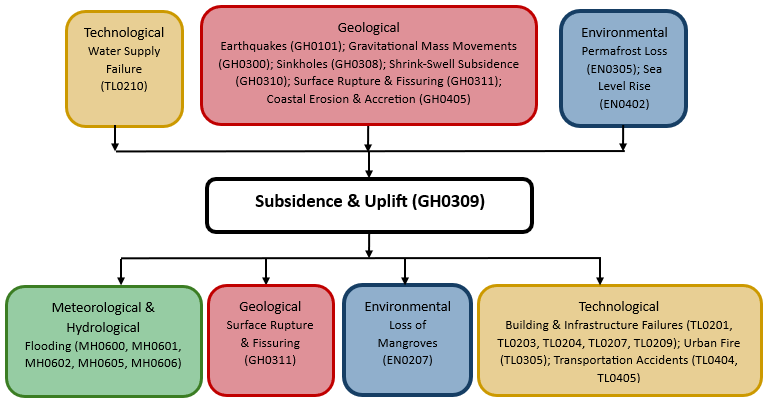
The figure below summarises common interactions between subsidence & uplift and other hazards. This information should be used with caution and not be solely relied upon in Disaster Risk Management, particularly as some interactions may not have been included. Note that hazardous events occurring together or locally in space or time may not necessarily cause, amplify or be otherwise related to each other. Specific examples of multi-hazard context can be found in the ‘Hazard drivers’ and ‘Impacts’ sections above.
Multi-hazard diagram
Risk Management
Before eruptions, uplift and/ or subsidence may be among the first signs that a magmatic system is restless, so monitoring and understanding ground deformation is critical to attempts to understand magmatic systems, forecast eruptions and mitigate volcanic risk (Dzurisin, 2007).
While no technology exists for reducing these or other earthquake hazards, the risk to infrastructure posed by surface rupture and fissures can be mitigated to some degree by not building on known fault traces, seismic retrofitting of existing buildings, and engineering of pipelines with enough flexibility to absorb the displacement by bending and shearing , rather than breaking (e.g., USGS, 2003).
Coastal change can impact harbour water depth and damage infrastructure. In these zones, modelling to enable adaptive planning is the best form of mitigation (Steven et al., 2020).
In areas where stopping anthropogenic groundwater dewatering leads to rising ground levels, as well as potential impacts on infrastructure, consideration should be given to impacts on water quality, such as where mine water rebound results in the mixing of mining and potable water (Boak et al., 2007).
Monitoring
The section and the table below offer an overview of monitoring subsidence & uplift. This information can be used for forecasting within a national early warning system (EWS). Since EWS capacities and processes differ across countries, the most current and specific information regarding EWS should be obtained from the appropriate national or regional agency/authority responsible for disaster management.
| Which institution(s) produce(s) Disaster Risk Data/Information? | No Information Available |
| How is the Hazard Observed/Monitored/Forecast? | Commonly using InSAR and GNSS stations, for instance in monitoring of pipelines and volcanic regions. |
References
Acocella, V., 2019. Bridging the gap from caldera unrest to resurgence. Frontiers of Earth Science, 7:173. 10.3389/feart.2019.00173 Accessed 11 October 2024.
Barberi, F., Corrado, G., Innocenti, F., Luongo, G., 1984. Phlegraean fields 1982-1984: brief chronicle of a volcano emergency in a densely populated area. Bulletin of Volcanology, 47:175-185.
Bateson, L., Novellino, A., Hussain, E., Arnhardt, R., Nguyen, H.K., 2023. Urban development induced subsidence in deltaic environments: A case study in Hanoi, Vietnam. International Journal of Applied Earth Observation and Geoinformation, 125, p.103585. https://doi.org/10.1016/j.jag.2023.103585 Accessed 7 April 2025.
Biasi, G.P., Weldon, R.J., 2006. Estimating surface rupture length and magnitude of paleoearthquakes from point measurements of rupture displacement. Bulletin of the Seismological Society of America, 96:1612-1623.
British Geological Society (BGS), 2020. Subsidence and shrinking and swelling soils. British Geological Survey (BGS). Accessed 11 October 2024.
Boak, R., Bellis, L., Low, R., Mitchell, R., Hayes, P., McKelvey, P., Neale, S., 2007. Hydrogeological impact appraisal for dewatering abstractions. Environment Agency Report SC040020/SR1.
Cigna, F., Banks, V.J., Donald, A.W., Donohue, S., Graham, C., Hughes, D., McKinley, J.M., Parker, K., 2017. Mapping ground instability in areas of geotechnical infrastructure using satellite InSAR and small UAV surveying: A case study in Northern Ireland. Geosciences, 7:51. 10.3390/geosciences7030051.
Dzurisin, D., 2007. Volcano Deformation. Springer.
Holbrook, J. Schumm, S.A., 1999. Geomorphic and sedimentary response of rivers to tectonic deformation: a brief review and critique of a tool for recognizing subtle epeirogenic deformation in modern and ancient settings. Tectonophysics, 305:287- 306
Meldebekova, G., C. Yu, Z. Li and C. Song, 2020. Quantifying ground subsidence associated with aquifer overexploitation using space-borne radar interferometry in Kabul, Afghanistan. Remote Sensing, 12:2461.
Pacific Northwest Seismic Network (PNSN), no date. Surface rupture. Pacific Northwest Seismic Network (PNSN). Accessed 7 April 2025.
Ricci, T., Barberi, F., Davis, M.F., Isaia, R., Nave, R., 2013. Volcanic risk perception in the Campi Flegrei area. Journal of Volcanology and Geothermal Research, 254:118-130
Rygus, M., Bianchi, M., Novellino, A., Hussain, E., Taufiq, A., Rusli, S.R., Sarah, D., Meisina, C., 2025. Permanent aquifer storage loss from long-term groundwater withdrawal: A case study of subsidence in Bandung (Indonesia). Journal of Hydrology: Regional Studies, 57, p.102129. https://doi.org/10.1016/j.ejrh.2024.102129 Accessed 7 April 2025.
Schmidt, B.P., Lund, B., Hieronymus, C., Maclennan, J., Árnadóttir, T., Pagli, C., 2013. Effects of present-day deglaciation in Iceland on mantle melt production rates. Journal of Geophysics. Research, 118:3366-3379.
Simic, D., M.G. Winter, D.M. Smith, P.J.L. Eldred and D.G. Toll, 2015. Seasonal ground movements of swelling clay subgrades. Accessed 11 October 2024.
Simon, K.M., James, T.S., Henton, J.A. Dyke, A.S., 2016. A glacial isostatic adjustment model for the central and northern Laurentide Ice Sheet based on relative sea level and GPS measurements. Geophysical Journal International, 205:1618-1636.
Steven, A.D.L., K. Appeaning Addo, G. Llewellyn, T.C. Vu, et al. 2020. Coastal Development: Resilience, Restoration and Infrastructure Requirements. World Resources Institute. Accessed 7 April 2025.
Styron, R., 2019. Coseismic uplift and subsidence. Global Earthquake Model Foundation Hazard Blog. Accessed 7 April 2025.
United States Geological Survey (USGS), 2003. The Trans-Alaska Oil Pipeline survives the quake – A triumph of science and engineering. United States Geological Survey (USGS). Accessed 11 October 2024.
United States Geological Survey (USGS), 2015. The Himalayas: Two continents collide. United States Geological Survey (USGS). Accessed 11 October 2024.