Sinkhole
Sinkholes (also known as dolines) are depressions or holes in the ground caused by the dissolution, collapse or erosion of rock below the landsurface. This is one of several hazards that result in subsidence, i.e., lowering or collapse of the ground (adapted from USGS, no date; and BGS, no date).
Primary reference(s)
BGS, UKRI. 2024. Understanding sinkholes and karst. British Geological Survey (BGS). Accessed 26 July 2024.
USGS, 2018. Sinkholes. United States Geological Survey (USGS). Accessed 26 July 2024.
Annotations
Additional scientific description
Dolines (sinkholes) are part of the hydrological system that shapes karst landscapes (landscapes resulting from the dissolution of soluble rocks such as chalk, gypsum or limestone). They can be considered in terms of fluid recharge, through-flow and discharge (e.g., springs and discharge points). Their rates of formation reflect the lithological and hydrological conditions (head and discharge).
Groundwater chemistry is important in influencing the rate and distribution of sinkholes. For example, while limestone is only very weakly soluble in water of neutral pH, its solubility increases in acidic conditions, such as due to the input of carbon dioxide from biological transpiration or due to the oxidation of pyrite. Commonly, the mixing of water from different flow paths results in increased dissolution potential. Dissolution may result from both meteoric recharge and groundwater or hypogene fluid flow (water or other fluids and gases) (Dublyansky, 2014).
Sinkholes are classified in accordance with the mode of formation, including but not limited to the following (e.g., Waltham et al., 2004):
- a dissolution sinkhole is formed by dissolutional lowering of the exposed soluble rock surface in and around zones of water recharge to soluble rock;
- a subsidence sinkhole results from recharge water mobilisation of sediment into underlying cavernous rock;
- a suffosion sinkhole is formed due to recharge water mobilisation of sediment through unconsolidated sediment cover over karst;
- a collapse sinkhole results from the collapse of insoluble capping rock into underlying cavernous rock;
- a buried sinkhole is sediment filled;
- a drop out sinkhole is formed rapidly due to soil cover collapse.
The triggering of sinkholes can also be the result of either surface or subsurface changes in load or groundwater conditions. Although a natural process, the formation of sinkholes is often accelerated or triggered by human action, for example collapse subsidence associated with mining Sinkholes can also occur in specific non-soluble rock settings such as lava tubes or pseudokarst.
Other types of karst hollow (EPA, 2002) with internal drainage include karst geomorphological features referred to as uvala (a closed depression with multiple recharge points), polje (a closed depression with a wide flat-floored and long axis developed parallel to major structural trends), cockpit (a star-shaped depression with a concave floor and surrounded by steep convex hill slopes) and structurally guided pipes.
Many new sinkholes have been correlated to land-use practices, especially from groundwater pumping and construction and development practices. Sinkholes can also form when natural water-drainage patterns are changed, and new water-diversion systems are developed. Some form when the land surface is changed, such as when industrial and runoff-storage ponds are created. The substantial weight of the new material can trigger an underground collapse of supporting material, causing a sinkhole (USGS, 2018).
The overburden sediments that cover buried cavities in some aquifer systems are delicately balanced by groundwater fluid pressure, whereby the water below ground is actually helping to keep the surface soil in place. Groundwater pumping for urban water supply and for irrigation can produce new sinkholes in sinkhole-prone areas. If pumping results in a lowering of ground- water levels, then underground structural failure, and thus, sinkholes can occur (USGS, 2018).
Broken land drains, water mains and sewerage pipes, increased rainfall, storm events, modified drainage and diverted surface water can all help wash sediment into the underlying soluble rock, causing subsidence. There have been many well documented occurrences of sinkholes forming beneath broken water mains, unlined storm-water culverts and leaking swimming pools (BGS, 2024). In some locations dissolution is driven by the upward movement of groundwater
Metrics and numeric limits
Currently, there is no systematic reporting of global sinkholes and their impacts. The size and density of sinkholes reflect the distribution of recharge or flow paths, for example, surface karst with numerous small recharge points (diffuse flow) over heavily fractured, more permeable rock, or fewer large recharge points in lower permeability strata. Similarly, where groundwater flow dominates, sinkhole formation processes are focused on structural and lithological boundaries. The size of sinkholes ranges from a few centimetres to hundreds of metres in diameter, and depths of decametres to a hundred metres or more.
Key relevant UN convention / multilateral treaty
Sendai Framework for Disaster Risk Reduction 2015-2030.
Drivers
The formation of sinkholes can be influenced by heavy or prolonged rainfall, changing groundwater levels (natural and anthropogenic), inundation (e.g., flooding or pipe leakage), loading (e.g., flooding or construction), erosion, and weathering and ground vibration. Sinkholes can also form as a result of sub-surface activity such as mining or tunnelling. In many landscapes, sinkholes form imperceptibly slowly (USGS, 2018; BGS, 2024).
Impacts
Collapse subsidence can be rapid. This is particularly significant in urban landscapes where the surface rupture can damage buildings and infrastructure, occasionally associated with loss of life (Waltham et al., 2004). For example, sinkholes in Guatemala City in 2007 and 2010 damaged roads, buildings and resulted in loss of life (Hermosilla, 2012).
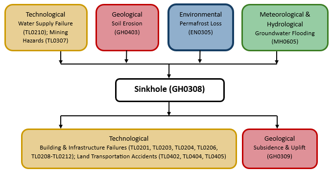
Multi-hazard context
The figure below summarises common interactions between earthquake and other hazards. This information should be used with caution and not be solely relied upon in Disaster Risk Management, particularly as some interactions may not have been included. Note that hazardous events occurring together or locally in space or time may not necessarily cause, amplify or be otherwise related to each other. Specific examples of multi-hazard context can be found in the ‘Hazard drivers’ and ‘Impacts’ sections above.
Multi-hazard diagram
Risk Management
The best form of control is avoidance through planning: various remote sensing, geophysical and intrusive ground investigation techniques can be applied to locating sinkholes to enable the design of construction methods, for example, transferring load to more competent strata with piles, or the incorporation of span distances for rafts or geotextiles (Waltham et al., 2004). Some construction techniques focus on void filling, for example, types of grouting are used to prevent or remediate sinkholes (Waltham et al., 2004).
Any remediation solution should fully consider the hydrological and hydrogeological context.
Monitoring
No Information Available
References
British Geological Survey (BGS), 2024. Understanding sinkholes and karst. British Geological Survey (BGS). Accessed 26 July 2024.
Dublyansky, Y.V., 2014. Hypogene speleogenesis – discussion of definitions. Hypogene Cave Morphologies Karst Waters Institute Special Publication 18. Accessed 26 July 2024.
US EPA, 2002. A Lexicon of Cave and Karst Terminology with Special Reference to Environmental Karst Hydrology. United States Environmental Protection Agency (US EPA). Accessed 26 July 2024.
Hermosilla, R.G., 2012. The Guatemala city sinkhole collapses. Carbonates and evaporites, 27(2), pp.103-107.
USGS, 2018. Sinkholes. United States Geological Survey (USGS). Accessed 26 July 2024.
Waltham, T., F. Bell and M. Culshaw, 2004. Sinkholes and Subsidence. Karst and Cavernous Rocks in Engineering and Construction. Springer-Praxis.