Submarine Gravitational Mass Movement (‘Landslide’)
A submarine gravitational mass movement (‘Landslide’) is the downslope movement of sediment or rock due to gravity, occurring when the downslope forces exceed the sediment's resistance to movement (Adapted from Lee et al., 2007).
Primary reference(s)
Lee, H.J., J. Locat, P. Desgagnés, J,.D. Parsons, B.G. McAdoo, D.L. Orange, P. Puig, F. Wong, P. Dartnell and E. Boulanger, 2007. Submarine mass movements on continental margins. In: Continental Margin Sedimentation. pp. 213-274. Wiley.
Annotations
Additional scientific description
Submarine gravitational mass movements ('Landslides') commonly occur in fjords, submarine canyons, active river deltas, volcanic islands, and open continental slopes. Evaluating the stability of seabed sediment requires understanding the driving stresses and sediment strength. Driving stresses include gravity, earthquakes, and storm waves. Resisting strength is reduced by pore water and gas pressures, groundwater seepage, rapid sediment deposition, cyclic loading, and human activity. Once slopes have become unstable or have failed, sediment strength may continue to decrease so, following slope failure, the failed mass moves downslope under the influence of gravity.
Submarine gravitational mass movements are classified as mass sediment movements. These include slides (translational and rotational slumps) and mass flows (mudflow, debris flow, liquefaction and turbidity current). If the moving sediment is a viscous fluid, this is termed a mass flow (gravity flow). If the movements are essentially rigid, internally undeformed masses along discrete slip planes, they are termed slides. Movement formed by 'blocks' of failed material rotating along curved slips are called slumps. Movement on a planar surface are termed translational slides. In both types, movement can be fast or slow. Extremely slow movement is called creep (see GH0302). Submarine slides can become mass flows (gravity flows) as the failed mass progressively disintegrates and continuous downslope movement occurs. End members of disintegrating slides have different terms. Debris flows are where the sediment is heterogeneous and may include larger clasts supported by a matrix of fine sediment. Mud flows are predominantly muddy sediment. Turbidity currents involve the downslope transport of a relatively dilute suspension of sediment grains that are supported by an upward component of fluid turbulence. Recent submarine landslide research has: (i) shown that landslides and sediment waves may generate similar deposits, which require careful interpretation; (ii) expanded knowledge of how strength develops in marine sediment; (iii) improved techniques for predicting sediment rheology; and (iv) developed methodologies for mapping and predicting the medium- to large-scale regional occurrence of submarine landslides.
Most submarine gravitational mass movements have multiple causes, which differ significantly from their subaerial counterparts. For example, the gradient of a seabed slope is not always a determining factor, as some of the largest submarine landslides occur on the shallowest slopes. Submarine gravitational mass movements are triggered by an increase in driving stresses, a decrease in sediment strength, or a combination of the two. These triggers include erosion , rapid sedimentation on delta fronts and earthquakes. Erosion is common in deep-sea channels, submarine canyons and other active sediment-transport systems. When seabed surfaces are undercut, this can decrease the stability by increasing shear stress and/or decreasing the shear strength. With earthquakes, the earthquake-induced shear stresses are large relative to sediment shear strength because the earthquake must accelerate all the sediment column including the interstitial water. The sediment shear strength is lowered because it builds up in proportion to the submerged unit weight of the sediment and may be even lower if there are excess pore pressures. The ratio of driving stress to resisting strength is high relative to that on land. Rapid sediment accumulation contributes to failure because most of the weight of newly added sediment is carried by pore-water pressures and the shear stress acting downslope increases more rapidly. The shear stress may also increase because more sediment may be deposited at the head of the sloping surface than at the toe, exceeding the critical slope angle of sediment. In addition, the following may result in failure: retarded sediment shear strength development, increased development of shear stress because of thickness of the sediment body, and increased development of shear stress because of increases in the slope steepness.
Metrics and numeric limits
Submarine gravitational sediment movement has been recorded during two events where submarine telephone cables were broken. The velocities recorded were up to 28 m/s (101 km/h) during the 1929 Grand Banks event and 5 to 16 m/s (18–57 km/h) in the Strait of Luzon between Taiwan and the Philippines from 2006 to 2015. (Løvholt, et al., 2018)
Key relevant UN convention / multilateral treaty
Sendai Framework for Disaster Risk Reduction 2015-2030.
Drivers
The drivers of submarine gravitational mass movements include gravity, earthquakes and storm waves. They can be triggered by ground shaking (see GH0101) from earthquakes and volcanic activity, for example on volcanic islands, or submarine volcanoes.
Impacts
In coastal and offshore regions, submarine gravitational mass movements threaten installations including oil platforms, pipelines, cables, and wind turbines. Mass submarine sediment failures are also one of the most important sources of sedimentation from shallow to deep-water environments and of shaping continental margins (McAdoo et al., 2000). Hence, a better understanding of submarine gravitational mass movements is of great importance in the development of offshore resources exploration and protection, sustainable flood risk management, hazard assessments for engineering and environmental projects, and also in hydrocarbon reservoir managements (McAdoo and Watts, 2004; Masson et al., 2006).
Understanding submarine gravitational mass movements has primarily focused on their role in generating tsunamis. For example, in 1969, an oil platform in the Gulf of Mexico collapsed when the soft seabed was destabilised during a hurricane. The most important historical event with significant loss of life was in 1998 in Papua New Guinea when a slump generated tsunami killed over 2200 people on the nearby coast. Other important events include the 1929 Grand Banks (M7.2) earthquake induced landslide tsunami in which 28 people died, and in 1964 during the Great Alaska earthquake, when submarine gravitational mass movements in Resurrection Bay and Port Valdez caused tsunamis that killed 45 people (Parsons et al., 2014). An additional risk is posed to submarine telegraph and fibre optic cables. For example, in 1929 the Grand Banks gravitational mass movement broke trans-Atlantic telegraph cables off Newfoundland.
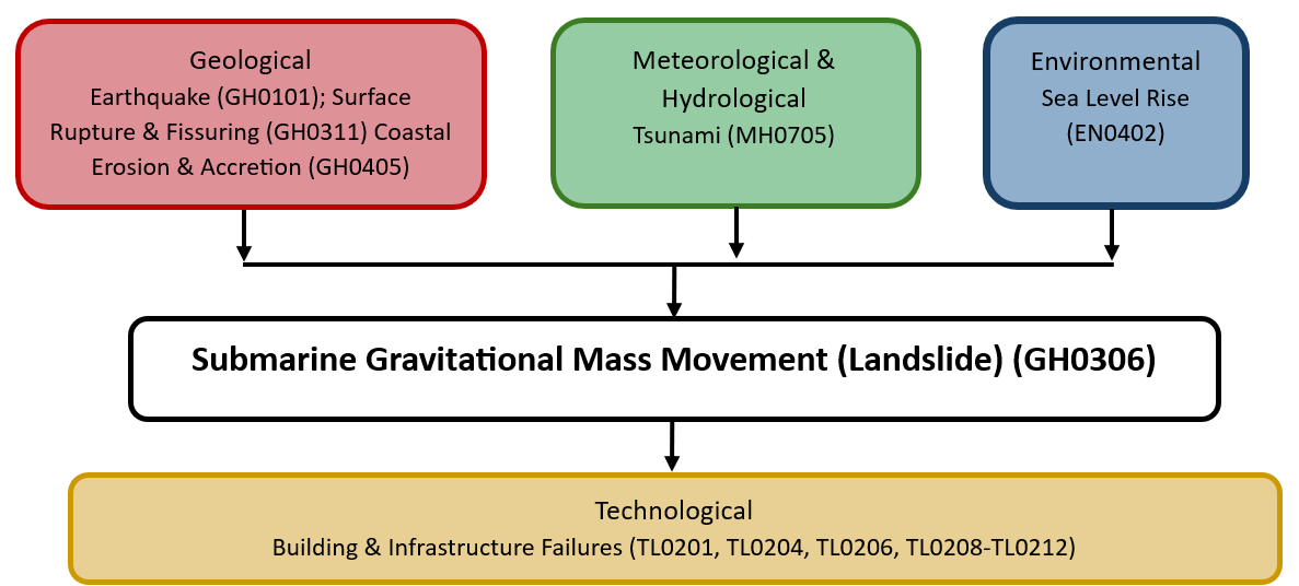
Multi-hazard context
The figure below summarises common interactions between submarine gravitational mass movements and other hazards. This information should be used with caution and not be solely relied upon in Disaster Risk Management, particularly as some interactions may not have been included. Note that hazardous events occurring together or locally in space or time may not necessarily cause, amplify or be otherwise related to each other. Specific examples of multi-hazard context can be found in the ‘Hazard drivers’ and ‘Impacts’ sections above.
Multi-hazard diagram
Risk Management
Not Applicable
Monitoring
Hydroacoustic and seismic networks are in use for particularly susceptible regions.
References
Lee, H.J., Locat, J., Desgagnés, P., Parsons, J.D., McAdoo, B.G., Orange, D.L., Puig, P., Wong, F., Dartnell, P. and Boulanger, E., 2007. Submarine Mass Movements on Continental Margins. In: C.A. Nittrouer, Austin, James A., Field, Michael E., Kravitz, Joseph H., Syvitski, James P. M., Wiberg, Patricia L. (Editor), Continental Margin Sedimentation. Wiley, pp. 213-274.
Løvholt, F., Schulten, I., Mosher, D., Harbitz, C. and Krastel, S., 2018. Modelling the 1929 Grand Banks slump and landslide tsunami. Geological Society, London, Special Publications, 477.
Masson, D.G., C.B. Harbitz, R.B. Wynn, G. Pedersen and F. Løvholt, 2006. Submarine landslides: processes, triggers and hazard prediction. Philosophical Transactions of the Royal Society A 364:2009-2039.
McAdoo, B.G. and P. Watts, 2004. Tsunami hazard from submarine landslides on the Oregon continental slope. Marine Geology, 203:235-245.
McAdoo, B.G., L.F. Pratson and D.L. Orange, 2000. Submarine landslide geomorphology, US continental slope. Marine Geology, 169:103-136.
Parsons, T., Geist, E.L., Ryan, H.F., Lee, H.J., Haeussler, P.J., Lynett, P., Hart, P.E., Sliter, R. and Roland, E., 2014. Source and progression of a submarine landslide and tsunami: The 1964 Great Alaska earthquake at Valdez. Journal of Geophysical Research: Solid Earth, 119(11): 8502-8516.
Tappin, D.R., Watts, P. and Grilli, S.T., 2008. The Papua New Guinea tsunami of 17 July 1998: anatomy of a catastrophic event. Nat. Hazards Earth Syst. Sci., 8(2): 243-266.