Rock, debris and earth topples
A topple is the forward rotation out of the slope of a mass of soil or rock about a point or axis below the center of gravity of the displaced mass (Cruden and Varnes, 1996).
Sub-categories of topples may be defined by the type of material (e.g., rock, soil, debris, or earth, modes of toppling (Goodman and Bray, 1976) and the velocity of the mass movement (cf. Cruden and Varnes, 1996; Hungr et al., 2014).
Primary reference(s)
Cruden, D.M., Varnes, D.J.,1996, Landslide Types and Processes, Transportation Research Board, U.S. National Academy of Sciences, Special Report, 247: 36-75
Goodman, R.E., and Bray, J.W. 1976. Toppling of Rock slopes, in Specialty Conference on Rock Engineering for foundations and slopes. Boulder, Colorado. American Society of Civil Engineers. 201-234.
Hungr, O., S. Leroueil and L. Picarelli, 2014. The Varnes classification of landslide types, an update. Landslides, 11:167-194.
Annotations
Additional scientific description
Topples may lead to falls or slides of the displaced mass depending on the geometry of the moving mass, on the geometry of the surface of separation, and on the orientation and extent of the kinematically active discontinuities.
Goodman and Bray (1976) describe several modes of toppling (further discussed by Hungr et al. 2014):
- Flexural topples - occur in rocks with one preferred discontinuity system, oriented to present a rock slope with semi-continuous cantilever beams
- Block topples - occur where the individual columns are divided by widely-spaced joints
- Chevron topples - occur where the dips of toppled beds are constant and the change of dip is concentrated at the surface of rupture.
- Block-flexure topples - are characterized by 'pseudo-continuous flexure of long columns through accumulated motions along numerous cross joints'
Metrics and numeric limits
Topples range from extremely slow to extremely rapid, sometimes accelerating throughout the movement (Cruden and Varnes, 1996).
Key relevant UN convention / multilateral treaty
Sendai Framework for Disaster Risk Reduction 2015-2030.
Drivers
Toppling is sometimes driven by gravity exerted by material upslope of the displaced mass, and sometimes by water or ice in cracks in the mass, or thermal expansion and vibration.
Impacts
Topples can be life-threatening. Topples can damage property beneath the fall-line of large rocks. A topple often results in the formation of debris or a debris cone at the base of the slope; this pile is called a talus cone. New talus cones do not have any plants growing on them. Old talus cone can have weeds and even trees on them.
Multi-hazard context
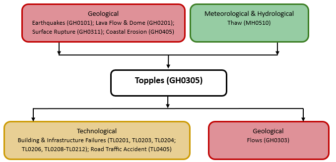
The figure below summarises common interactions between topples and other hazards. This information should be used with caution and not be solely relied upon in Disaster Risk Management, particularly as some interactions may not have been included. Note that hazardous events occurring together or locally in space or time may not necessarily cause, amplify or be otherwise related to each other. Specific examples of multi-hazard context can be found in the ‘Hazard drivers’ and ‘Impacts’ sections above.
Multi-hazard diagram
Risk Management
Mitigation measures for rock, debris and earth topples are similar to those for rockfalls and include rock curtains or other slope covers, protective covers over roadways, retaining walls to prevent rolling or bouncing, explosive blasting of hazardous target areas to remove the source (scaling), removal of rocks or other materials from highways and railroads can be used to minimise risk (Sassa et al., 2018).
Rock bolts or other similar types of anchoring used to stabilise cliffs, as well as scaling, can lessen the hazard. Warning signs are recommended in hazardous areas for awareness. Stopping or parking under hazardous cliffs should be warned against (Highland and Bobrowsky, 2008).
Monitoring
The section and the table below offer an overview of monitoring topples. This information can be used for forecasting within a national early warning system (EWS). Since EWS capacities and processes differ across countries, the most current and specific information regarding EWS should be obtained from the appropriate national or regional agency/authority responsible for disaster management.
Which institution(s) produce(s) Disaster Risk Data/Information? | Local Authorities; Geological Surveys may produce disaster risk data/information |
| How is the Hazard Observed/Monitored/ Forecast? | Slopes or cliffs that topples may occur on can be monitored via satellite imagery, InSAR, and visual observations, among others. |
References
Cruden, D.M. and Varnes, D.J.,1996, Landslide Types and Processes, Transportation Research Board, U.S. National Academy of Sciences, Special Report, 247: Washington, DC: Transportation Research Board, National Research Council, pp.36–75.
Goodman, R.E., and Bray, J.W. 1976. Toppling of Rock slopes, in Specialty Conference on Rock Engineering for foundations and slopes. Boulder, Colorado. American Society of Civil Engineers. 201-234.
Highland, L.M. and P. Bobrowsky, 2008. The Landslide Handbook – A guide to understanding landslides. U.S. Geological Survey Circular 1325. Reston, VA: U.S. Geological Survey.
Hungr, O., S. Leroueil and L. Picarelli, 2014. The Varnes classification of landslide types, an update. Landslides, 11:167-194.
Sassa, K., F. Guzzetti, H. Yamagishi, Z. Arbanas, N. Casagli, M.J. McSaveney and K. Đặng (eds.), 2018. Landslide Dynamics: ISDR-ICL Landslide Interactive Teaching Tools. Accessed 9 December 2024.
Varnes, D.J., 1978. Slope movement types and processes. In: Schuster, R.L. and R.J. Krizek (eds), Landslides, Analysis and Control. Special report 176: Transportation Research Board, National Academy of Sciences, pp. 11-33.