Rock, debris and earth (mud) slide
A slide is a movement of a mass of rock, debris or earth on an individualized failure surface (adapted from Dennis and Didier, 2019).
Sub-categories of slides may be defined by the type of material (e.g., rock, soil, debris, or earth) and the velocity of the mass movement (cf. Cruden and Varnes, 1996; Hungr et al., 2014). Mud slides are here taken to be a sub-category of earth slides.
Primary reference(s)
Cruden, D.M., and Varnes, D.J.,1996, Landslide Types and Processes, Transportation Research Board, U.S. National Academy of Sciences, Special Report, 247: 36-75
Dennis, F. and H. Didier, 2019. Rock slides and rock falls, a fatality? Encyclopaedia of the Environment (2019). Accessed 20 October 2024.
Hungr, O.; Leroueil, S.; Picarelli, L, 2014. The Varnes Classification of Landslide Types, an Update. Landslides, 11:167-194. DOI 10.1007/s10346-013-0436-y.
Annotations
Additional scientific description
Different types of slides can be distinguished according to the shape of the failure surface. These can be identified as translational slides and rotational slides:
- Translational slides generally occur on one or two planes (referred to as 'wedges') of pre-existing discontinuity(s) in the rock mass. A well-known example in France is the Claps de Luc-en-Diois where, in 1442, thick limestone beds slipped on a stratification plane following the erosion of the foot of the slope by the Drôme River. The volume of the slip exceeded 1 hm3. But the largest rock slide in the Alps in the last two millennia was the one that affected the marl slope north of Mont Granier in November 1248. Nearly 500 hm3 of marl rock slid eastward on the stratification joints, destroying several villages and killing more than 1000 people (Dennis and Didier, 2019).
- Rotational slides occur on an axisymmetric surface; they are sometimes called circular slides because on a vertical section, the failure surface is an arc of a circle. They can occur in continuous massifs (often in soils) or without discontinuity planes allowing translational sliding. An example is given by the slide from La Clapière to Saint-Etienne-de-Tinée in France, with a volume of about 50 hm3 (Dennis and Didier, 2019).
Metrics and numeric limits
Not identified.
Key relevant UN convention / multilateral treaty
Sendai Framework for Disaster Risk Reduction 2015-2030.
Drivers
High precipitation, natural erosion, temperature variations or extreme stresses such as earthquakes can trigger rock slides and rock falls.
Impacts
Six of the 26 catastrophic landslides of the 20th Century listed by the United States Geological Survey (2018) were associated with rock slides, including the Usoy rock slide, USSR (1911); Khait rock slide, USSR (1949, 12,000 to 20000 deaths); and the Bairaman rock slide debris avalanche, Papua New Guinea (1986, village destroyed). These three rock slides were triggered by earthquakes. In 1974 in Peru, the Mayunmarca rock slide-debris avalanche, which resulted in the loss of 450 lives was associated with high rainfall.
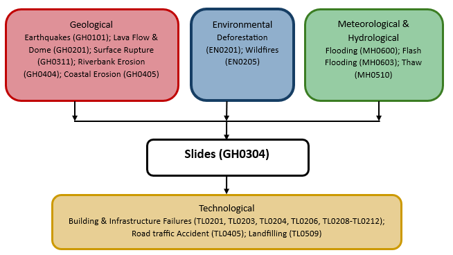
Multi-hazard context
The figure below summarises common interactions between earthquake and other hazards. This information should be used with caution and not be solely relied upon in Disaster Risk Management, particularly as some interactions may not have been included. Note that hazardous events occurring together or locally in space or time may not necessarily cause, amplify or be otherwise related to each other. Specific examples of multi-hazard context can be found in the ‘Hazard drivers’ and ‘Impacts’ sections above.
Multi-hazard diagram
Risk Management
In terms of natural hazards, the Encyclopaedia of the Environment reported two categories of protection: active protections to remove the hazard itself and passive protections, which do not seek to oppose natural phenomena only to limit their harmful consequences for developments (buildings, communication routes) (Dennis and Didier, 2019).
- Active protections are diverse and include (i) general methods, such as surface or deep drainage, and slope vegetation that limits erosion due to runoff (gully excavation) and infiltration that alters mechanical properties (friction, cohesion of rock joints); (ii) supports, such as retaining walls, rock bolts or anchored mesh covered with sprayed concrete; (iii) wire mesh (draped or pinned), i.e., metal structures designed to contain the massif and prevent the spread of falling rocks and blocks; and (iv) scaling/mining, which are radical solutions that comprise removing unstable elements, although these solutions are not always as definitive as expected (the continuous alteration and the blast vibrations are often harmful to the stability of the surrounding massifs) (Dennis and Didier, 2019).
- Passive protections are also diverse: (i) barriers and dikes are gabions or concrete blocks placed at the foot of unstable slopes; their purpose is to stop the propagation of rock elements before reaching the stakes; their location, which requires sufficient space and their dimensioning, takes into account the properties of the materials that constitute them, but first of all numerical simulations that are made to model the propagation of blocks (trajectory circulations); (ii) the diverters are also embankments; installed on the slope, they divert the flow of the elements towards a space without stakes; (iii) protection galleries, similar to avalanche tunnels, are likely to protect communication routes when crossing corridors; (iv) rigid fences are placed on steep slopes as close as possible to the starting areas; their installation is often difficult to achieve; and (v) deformable wire-mesh can be placed lower on the slopes until they are close to the issues at stake; the most well-known case is the use of ‘submarine’ type nets (used during the Second World War to prevent the penetration of ports by submarine vehicles) stretched between rigid poles and maintained by fusible carabiners; this device is thus calculated to resist an impact energy previously determined in the study of randomness and its propagation (Dennis and Didier, 2019).
The appropriate responses to reduce the risks associated with rock instabilities are effective but often require a large budget. It is not viable to consider eliminating risk wherever it exists. The best protection is always based first on geological reconnaissance, followed by preventative actions such as drainage or regular purging of unstable elements and on monitoring based on measurements when movements are detected. Such monitoring often triggers an alert with a road closure or evacuation of an inhabited area (Dennis and Didier, 2019).
Monitoring
The section and the table below offer an overview of landslide monitoring. This information can be used for forecasting within a national early warning system (EWS). Since EWS capacities and processes differ across countries, the most current and specific information regarding EWS should be obtained from the appropriate national or regional agency/authority responsible for disaster management.
Which institution(s) produce(s) Disaster Risk Data/Information? | Local Authorities; Geological Surveys can produce disaster risk data / information |
| How is the Hazard Observed/Monitored/ Forecast? | Slides can be monitored via satellite imagery, InSAR, and visual observations, among others. |
References
Cruden, D.M., Varnes, D.J.,1996, Landslide Types and Processes, Transportation Research Board, U.S. National Academy of Sciences, Special Report, 247. Washington, DC: Transportation Research Board, National Research Council, pp.36–75.
Dennis, F. and H. Didier, 2019. Rock slides and rock falls, a fatality? Encyclopaedia of the Environment (2019). Accessed 13 February 2025.
Hungr, O., S. Leroueil and L. Picarelli, 2014. The Varnes classification of landslide types, an update. Landslides, 11:167-194. DOI 10.1007/s10346-013-0436-y
Norwegian Geotechnical Institute (NGI) n.d. Rock slides. Accessed 13 February 2025.
United States Geological Survey (USGS), 2018. Catastrophic Landslides of the 20th Century – Worldwide. United States Geological Survey (USGS). Accessed 13 February 2025.