Debris and earth (mud)flows and rock avalanches
Flows are gravitational mass movements down a slope in the form of a fluid. Flows often leave behind a distinctive, fan-shaped deposit where the landslide material has stopped moving (cf. British Geological Survey 2024)
Sub-categories of flows may be defined by the type and proportion of material (e.g., soil, debris, or earth and the velocity of the mass movement, cf. Cruden and Varnes, 1996; Hungr et al., 2014). Mud flows are here taken to be a sub-category of earth flows. The term rock avalanche implies extremely rapid, massive, flow-like motion of fragmented rock from a large rock slide or rock fall (Hungr. et al., 2014).
Primary reference(s)
BGS 2024. British Geological Survey, Discovering Geology — Understanding landslides. Accessed 24 October 2024.
Hungr, O., S. Leroueil and L. Picarelli, 2014. The Varnes classification of landslide types, an update. Landslides, 11:167-194. DOI 10.1007/s10346-013-0436-y
Annotations
Additional scientific description
Debris flows and earth flows usually occur in small, steep stream channels and are commonly mistaken for floods (Highland and Bobrowsky, 2008). The boundary between debris flow and mud flow is gradational with a mud flow consisting of finer sediment (Hungr et al., 2014).
One of the most common types of gravitational mass movements triggered by intense precipitation is a debris flow. It is often called a channelized debris flow as it is triggered in steep mountain stream channels, usually during intense precipitation events, but also during rapid snowmelt. In the media, a debris flow will often be termed a mud slide or mud flow. Another type of debris flow is called a hill slope debris flow, which is also synonymous with debris avalanche (Hungr et al., 2014).
Rock avalanches are a translational form of mass movement where the transported material is dry rock that is fragmented before or during slope failure. They are rapid with long runouts and large volumes and often involve the entrainment of slope material, commonly therefore, giving rise to debris slides or flows. The motion of rock avalanches is massive such that the bulk of the rock fragments move together as a largely coherent mass (Collins, 2014).
Often, there is a gradation of change from slides to flows, depending on the water content, mobility, and evolution of the movement.
Metrics and numeric limits
There is no systematic way of recording debris flows globally but they may exist at country level. Volume range (10³–10⁶ m³) for most events (Hungr et al., 2014; Jakob & Hungr, 2005).
Key relevant UN convention / multilateral treaty
Sendai framework for Disaster Risk Reduction 2015-2030.
Drivers
Flows are generated by precipitation, melting of summit ice or snow from volcanic heat, or glacial outburst floods (Hungr et al., 2014). They can also develop from falls (see GH0301) and rock avalanches, which can evolve into debris flows.
Climate change impacts on permafrost have been associated with increasing incidence of rock avalanche initiation triggered by melting ice or thawing permafrost (USGS, 2018).
Impacts
Rock, debris and earth flows can have devastating impacts. An example of a mud flow is in Indonesia, where on 29 May 2006, hot mud and gas began gushing from a rice field near a gas exploration well in East Java. More than a decade later, the Lusi mud flow continues on the Indonesian island (NASA, 2019). Over the years, flows of boiling mud from the Lusi Mud Flow have displaced more than 40,000 people, destroyed 15 villages, and caused nearly USD 3 billion in damage (NASA, 2019). The Lusi eruption has become one of the most dramatic and damaging eruptions of its type. Some villages have been buried by layers of mud 40 metres (130 feet) thick. The mud, which has a consistency similar to porridge, pours constantly from Lusi’s main vent. Every thirty minutes or so, surges in the flow send plumes of water vapour, carbon dioxide, and methane shooting tens of meters into the air (NASA, 2019).
Often referred to as “mud slide” in the media, British Columba Canada, suffered the impacts of an atmospheric river event in November 2021 triggering several debris flows/mud flows and floods as each major road, east of Vancouver was either blocked, destroyed or flooded (Watterodt and Doberstein, 2023). An atmospheric river event is a high intensity, warm precipitation event originating from the Pacific Ocean. From this event, five people were swept away by a debris flow north of Vancouver and east of Vancouver, two debris flows blocked a highway where more than 275 people were trapped for 48 hours. Major arteries were blocked for about a week; the costs were $675 million (Canadian currency) in insured losses, between $1-5 billion in uninsured losses, and between $900 million to $1.5 billion in estimated economic losses to the supply chain and labour market disruptions (Watterodt and Doberstein, 2023).
Rock avalanches pose some of the most dangerous and expensive geological hazards in mountainous terrain. Typical of these was the Frank Landslide, which occurred on 29 April 1903, and involved 110 million tonnes (~44 million cubic meters) of limestone released from the summit of Turtle Mountain, Alberta. The rock mass that fell was 150 m deep, 425 m high and 1 km wide (Frank Slide Interpretive Centre, 2018). The Frank Landslide occurred at night. It was triggered by unusual weather conditions (repeated freeze-thaw cycles) influenced also by subsurface mining. The rock avalanche buried part of the town of Frank killing at least 80 people in its path; it is Canada’s deadliest landslide event (Frank Slide Interpretive Centre, 2018).
In July of 2021, the town of Lytton, BC, Canada recorded the hottest place on earth (~49.9°C) for a few days. Soon after, it was ravaged by forest fires. The following month in August, debris flows triggered during heavy rains in steep stream channels contributed to the devastation in and around Lytton.
Multi-hazard context
The figure below summarizes common interactions between debris and earth (mud) flows and rock avalanches (know as flows)and other hazards. This information should be used with caution and not be solely relied upon in Disaster Risk Management, particularly as some interactions may not have been included. Note that hazardous events occurring together or locally in space or time may not necessarily cause, amplify, or be otherwise related to each other. Specific examples of multi-hazard context can be found in the ‘Hazard drivers’ and ‘Impacts’ sections above.
Multi-hazard diagram

Risk Management
Instrumental monitoring to detect movement and the rate of movement can be implemented, for example, extensometers, global positioning system (GPS), seismometers, aerial photography, satellite images, LiDAR (Highland and Bobrowsky, 2008) with varying degrees of success.
Mitigation actions include active protections to remove the hazard itself and passive protections, which seek to mitigate the impacts (e.g. on buildings, communication routes) (Dennis and Didier, 2024).
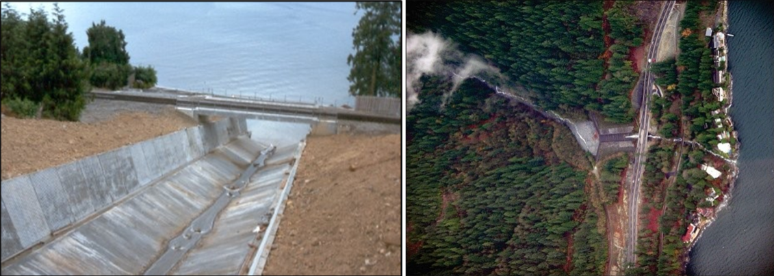
- Active protections can include (i) general methods, such as surface or deep drainage, and slope vegetation that limits erosion due to runoff (gully excavation) and infiltration that alters mechanical properties (friction, cohesion of rock joints); (ii) supports, such as retaining walls, rock bolts or anchored mesh covered with sprayed concrete; (iii) wire mesh (draped or pinned), i.e., metal structures designed to contain the massif and prevent the spread of falling rocks and blocks that could evolve into a flow; and (iv) scaling/mining, which are radical solutions that comprise removing unstable elements, although these solutions are not always as definitive as expected (the continuous alteration and the blast vibrations are often harmful to the stability of the surrounding massifs) (Dennis and Didier, 2024). Along the highway to Whistler BC, mitigation against debris flows was made building catchment basins (Blais-Stevens and Hungr., 2008).
- Passive protections include barriers, diverters, fences etc. that either divert, block or inhibit the flows. These are placed according to numerical simulation of flow hazard, and their use is dependent on the slope material. (i) barriers and dikes placed at the foot of unstable slopes to stop the propagation of rock elements before reaching infrastructure or other exposed assets; (ii) diverters or embankments can be installed on the slope to divert the flow towards a space without assets; (iii) protection galleries, similar to avalanche tunnels, are likely to protect communication routes when crossing corridors; (iv) rigid fences can be placed on steep slopes as close as possible to the starting areas; however, their installation is often difficult to achieve; and (v) deformable wire-mesh can be placed lower on the slopes until they are close to the issues at stake; the most well-known case is the use of ‘submarine’ type nets (used during the Second World War to prevent the penetration of ports by submarine vehicles) stretched between rigid poles and maintained by fusible carabiners; this device is thus calculated to resist an impact energy previously determined in the study of randomness and its propagation (Dennis and Didier, 2024).
Monitoring
The section and the table below offer an overview of monitoring flows. This information can be used for forecasting within a national early warning system (EWS). Since EWS capacities and processes differ across countries, the most current and specific information regarding EWS should be obtained from the appropriate national or regional agency/authority responsible for disaster management.
Which institution(s) produce(s) Disaster Risk Data/Information? | Local Authorities; Geological Surveys may produce disaster risk data/information |
| How is the Hazard Observed/Monitored/Forecast? | Slopes that may generate flows can be monitored via satellite imagery, InSAR, and visual observations, among others. Other techniques include threshold-based rainfall warning systems. |
References
Blais-Stevens, A., Hungr, O., 2008, Landslides and their mitigation along the Sea to Sky corridor, British Columbia, Proceedings from the 4th Canadian Conference on Geohazards, Quebec City QC, :495-502.
British Geological Survey, 2024. Discovering Geology — Understanding landslides. Accessed 24 October 2024.
Collins, G.S., 2014. Rock avalanche. In: Encyclopedia of Planetary Landforms. Springer. Accessed 15 October 2020.
Cruden, D.M. and Varnes, D.J., 1996. Landslide types and processes. In: Turner, A.K. and Schuster, R.L. (eds), Landslides: Investigation and Mitigation. Special Report 247. Transportation Research Board, National Research Council, Washington, DC, pp.36–75.
Dennis, F. and H. Didier, 2024. Rocky Landslides and Landslides A Fatality? Encyclopedia of the Environment. Accessed 24 October 2024.
Frank Slide Interpretive Centre, 2018. Canada’s Deadliest Rockslide. https://frankslide.ca/sites/frankslide/files/editor_files/Frank_Slide_F… Accessed 24 October 2024
Highland, L.M. and P. Bobrowsky, 2008, The landslide handbook — A guide to understanding landslides. US Geological Survey, Circular 1325. Reston, VA: Geological survey. Accessed 24 October 2024
Hungr, O., S. Leroueil and L. Picarelli, 2014. The Varnes classification of landslide types, an update. Landslides, 11:167-194. DOI 10.1007/s10346-013-0436-y.
Jakob, M., Hungr, O. and Jakob, D.M., 2005. Debris-flow hazards and related phenomena (Vol. 739). Berlin: Springer.
NASA, 2019. A Muddy Mess in Indonesia. National Aeronautics and Space Administration (NASA). Accessed 24 October 2024.
USGS, 2018. United States Geological Survey. Postfire debris-flow hazards. Accessed 24 October 2024.
Watterodt, F. and Doberstein, B., 2023, The post-disaster window: The 2021 British Columbia atmospheric river phenomenon as a focusing event for policy change, ICLR Quick Response Program, Final report, 33 p.