Lava Flows and Domes
Lava flows and lava domes form from molten rock that erupts and cools on or near the Earth’s surface. A lava flow is an outpouring of fluid, relatively low-viscosity molten rock, whereas a lava dome is a pile of relatively viscous lava that cannot flow far from the vent (cf. Dietterich et al., 2025; Harnett et al., 2025), the collapse of which may be hazardous.
Primary reference(s)
Calder, E.S., Y. Lavallee, J.E. Kendrick et al., 2015. Lava dome eruptions. In: Sigurdsson, H., B. Houghton, H. Rymer et al. (eds.), The Encyclopedia of Volcanoes, 2nd Edn. pp. 343-362. Academic Press.
Kilburn, C.R.J., 2015. Lava flow hazards and modelling. In: Sigurdsson, H., B. Houghton, H. Rymer et al. (eds.), The Encyclopedia of Volcanoes, 2nd Edn. pp. 957-969. Academic Press.
Annotations
Additional scientific description
A lava flow may comprise smaller masses of lava known as 'lava flow units', or 'lava flow lobes'; a lava flow comprising multiple lava flow units is known as a 'lava flow field'. Individual flows may branch around obstacles to create multiple flow fingers and may inflate or thicken from the original thicknesses. There are many types of lava flows. Pillow lavas are lava flows formed under water. Fluid, subaerial lava flows may be channelized ʻaʻā, lobate pāhoehoe, or blocky lavas. Lava domes may be described by their geometry. Domes are typically blocky and steep-sided and can contain uplifted solid plugs of lava (lava spines) which typically have a higher aspect ratio formed from stiffer more crystalline material. Lava coulées are a hybrid between lava domes and flows that form short, thick, viscous lava flows on a slope.
Most volcanoes erupt lava flows and/or domes during their lifetimes. Effusions of lava commonly continue from days to months, but occasionally last decades. Lava flows damage and destroy land and property but usually (not always) advance slowly enough for populations to escape. Understanding where future lava may be erupted from (the vent or vents), how far a lava flow may advance, the velocity of the flow front and the area that may be covered are critical for hazard assessments (Diettrich et al., 2025). Viscous lava domes are often crater-confined, so their flow runout typically does not destroy infrastructure. However, domes often collapse to generate very hazardous and fast-moving pyroclastic density currents (Charbonnier et al. 2025. See GH0203). The main factors controlling how a lava flow or dome develops are the rheological properties of the lava, effusion (or extrusion) rate and underlying topography.
The rheological properties of lava are influenced by chemical composition and factors such as pre- and syn-eruptive crystallization. Fluid and mobile lava flows tend to be low in silica (e.g., mafic compositions such as basalt); lava with moderate silica content is more viscous and tends to form short blocky lava flows or lava domes (e.g., intermediate compositions such as andesite); the most silica-rich lava is most likely to form a lava dome (e.g., felsic compositions such as rhyolite). The Cordón Caulle eruption in 2011-2012, shows that rhyolitic and basaltic compound lava flows may have much in common in terms of physical processes, despite very different rheologies (Tuffen et al., 2013).
Lava flows and domes typically have a molten core, with a solid crystallized outer shell, which crystallizes with increased degassing and cooling through time. Parts of lava flows and lava domes can therefore remain molten after an eruption has ended (Dietterich et al., 2025; Harnett et al., 2025). Lava flow advance of lava dome spreading can therefore occur outside of an active eruption
Lava flow characteristics: Surface morphology of subaerial basaltic lava flows may be described as pāhoehoe (Hawaiian meaning 'smooth, unbroken') or a'ā (Hawaiian meaning 'stony, rough lava'), whereas intermediate or silica-rich lava is more likely to have a blocky surface morphology.
Models: The simplest empirical models are volcano-specific and link effusion rate to runout length, but more complex models account for cooling-induced changes in rheology as lava flows downslope. Outputs are highly sensitive to topography, as well as effusion rate and flow dynamics (Dietterich et al., 2025). High resolution Digital Elevation Models are necessary but in urban and man-made environments Digital Surface Models may be more appropriate to account for the built environment.
Probabilistic hazard assessments for lava flows can anticipate inundation so are useful for long-term planning (e.g., hazard maps) and short-term forecasting (e.g., Vicari et al., 2011). However, more study is required at many volcanoes that lack important metrics such as recurrence interval, or volume of previous lava flows. New methodologies are constantly developing and generally have a two-step process: statistical analysis to establish known vent distributions and identify most likely future vent sites, followed by an estimation of the areas of inundation by lavas flowing from those vents using lava flow models (e.g., Gallant et al. 2018).
Lava flow and dome collapses: Viscous lava flows and domes may exhibit various collapse styles from persistent rock falls to partial or total collapse of a lava dome. Lava flow or dome collapse may generate pyroclastic density currents called block-and-ash flows and associated hazards such as tephra and gas emissions (Harnett et al., 2025). Lava dome collapse hazard assessments are rarely in place but are needed (Harnett et al., 2025).
Metrics and numeric limits
Basaltic pāhoehoe flows commonly have the highest eruption temperatures of 1050 to 1200°C, whereas rhyolitic lavas are typically 700-900°C (Diettrich et al., 2025). The unique 'natrocarbonatite' lava flows at Ol Doinyo Lengai volcano in Tanzania are dominated by carbonates rather than silicates and form very fluid, relatively low temperature lavas (500-600°C) (Pinkerton et al., 1995).
At the start of an eruption, basaltic lavas may advance at several kilometres per hour, but flow velocity decreases with distance to walking pace or less within a few hours (Diettrich et al., 2025). However, flow velocity decreases less dramatically with time for long-lived eruptions. On steep slopes some lavas may reach higher velocities of tens of kilometres per hour. Exceptionally, in 1977, lava flowed down the slopes of Nyiragongo with a maximum velocity of up to 100 km/h (Balagizi et al., 2018). Viscous lavas typically advance at rates of 0.1 km/day or less.
Basaltic lava flows typically reach lengths of 1-30 km, but occasionally more than 50 km (e.g., Mauna Loa 1859 eruption, Hawaii) (Diettrich et al., 2025). Basaltic lava flows may be 3-30 m thick and typical volumes of historical lava flows on land are between 0.01 and 1 km3 (flow fields can exceptionally exceed 10 km3). Intermediate and silicic lavas are usually shorter in length, typically up to 5 km but some are up to 15 km. They may be 20-300 m thick and volumes are typically 0.01 and 0.1 km3 but can be up to 10-20 km3 (Diettrich et al., 2025). If lava flows into a body of water, the interaction can form littoral explosions that deposit tephra locally, or the interaction may be passive and generate steam and formation of a lava delta.
Lava domes most commonly form in andesitic-dacitic composition but have also been observed at rhyolite volcanoes. Lava domes can grow at a range of extrusion rates (~0.01-100 m3/s) and vary in maximum volume from small lobes and spines (<0.0001 km3) to large summit domes (~0.5 km3) to enormous coulées (>5 km3), with most domes growing to ~0.001-0.2 km (Harnett et al., 2025).
Key relevant UN convention / multilateral treaty
Sendai Framework for Disaster Risk Reduction 2015-2030 (UNDRR, 2015).
Drivers
How a lava flow or dome develops depends on various factors including the rheological properties of the lava, effusion (or extrusion) rate, underlying topography, and the morphology of the flow (for example if it flows as a broad sheet, in a confined channel or in a lava tube).
Impacts
Between 1500 AD and 2017 there were 25 documented fatal incidents, and 659 fatalities caused directly by lava flows, with fatalities occurring between 1 and 29 km of the volcanic source (median distance 11 km) (Brown et al., 2017). Fatalities and casualties occur when eruptions begin from vents close to towns and/or lavas are very fluid, on steep slopes and fast moving. For example, the 1977 eruption of Nyiragongo generated lava flows that killed about 70 people (Balagizi et al., 2018). Deaths also occur near lava entry points into the ocean, where new lava flow surfaces are unstable. Viscous lava flows and lava domes do not directly cause fatalities and injuries, but their collapse may generate pyroclastic density currents which cause more fatalities than any other volcanic hazard (Brown et al., 2017). Dome growth episodes have also been related to major explosive activity, which can have impacts on the aviation sector.
Lava flows may cause damage to buildings, infrastructure, communications, agriculture and environment by inundation, burial, transport, fire and explosion (Jenkins et al., 2025). Damage may not be complete but partial burial or inundation by lava generally makes buildings, infrastructure and land unusable. Buried infrastructure may also be destroyed due to thermal impacts. Injuries may occur if individuals walk on a lava carapace with molten lava below. Health impacts may include burns, gas and aerosol inhalation.
Indirect impacts can include escape routes being cut off, or the lavas may trigger explosions on meeting snow, ice and water, or flammable fluids. For example, in Goma in 2002, around 300,000 people self-evacuated and there were roughly 140 deaths, most caused by explosions at a petrol station that had been surrounded by lava (Balagizi et al., 2018). Lava flows may ignite forest or urban fires. Volcanic gases and aerosols (air pollution) need to be considered, possibly over large areas. Evacuation to emergency accommodation may lead to permanent displacement, which if combined with loss of livelihoods and homes, may cause longer term mental and physical health impacts, and the long-term cascading effects can be more severe than immediate impacts (Wantim et al., 2018).
Multi-hazard context
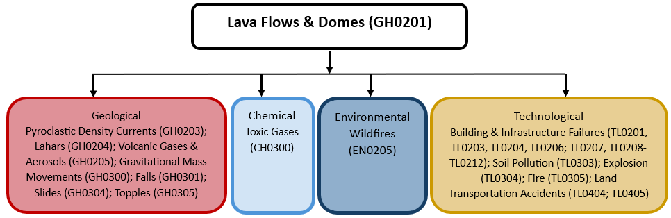
The figure below summarises common interactions between lava flows & domes and other hazards. This information should be used with caution and not be solely relied upon in Disaster Risk Management, particularly as some interactions may not have been included. Note that hazardous events occurring together or locally in space or time may not necessarily cause, amplify or be otherwise related to each other. Specific examples of multi-hazard context can be found in the ‘Hazard drivers’ and ‘Impacts’ sections above.
Multi-hazard diagram
Risk Management
If a volcanic area is well-monitored, the movement of magma in the subsurface may be detected days, weeks or even years before an eruption enabling planning, preparation and emergency actions such as evacuation. Effective monitoring of the emplacement of lava flows and domes over time enables forecasting of inundation and the anticipation of hazardous events such as lava dome collapse. Probabilistic hazard maps can enable appropriate land-use planning policies before eruption avoiding development in areas with high probability of inundation (Tsang and Lindsay, 2020).
Attempts during ongoing eruptions to halt or divert flows (by erecting barriers, spraying lava with water, or breaking the margins of lava channels) have had mixed success nevertheless, in Hawaii and Iceland (2023-2024 eruptions), barriers have been constructed alongside high value assets (Tsang and Lindsay, 2020; Icelandic Meteorological Office, 2024). Evacuation remains the most effective strategy for protecting life and health from lava flow hazards (Tsang and Lindsay, 2020).
Monitoring
The section and the table below offer an overview of monitoring lava flows & domes. This information can be used for forecasting within a national early warning system (EWS). Since EWS capacities and processes differ across countries, the most current and specific information regarding EWS should be obtained from the appropriate national or regional agency/authority responsible for disaster management.
| Which institution(s) produce(s) Disaster Risk Data/Information? | Volcano Observatories monitor precursory activity that could lead to hazards associated with volcanic unrest or eruption (including but not limited to ground shaking, ground fracturing, subsidence and uplift, and volcanic gases). Volcano Observatories issue warnings and, in association with civil protection and emergency management organizations, recommendations. Volcano Observatories monitor the emplacement and growth of lava flows and domes over time enabling forecasting of inundation and the anticipation of hazardous events. |
| How is the Hazard Observed/Monitored/Forecast? | The emplacement and growth of lava flows and domes can be observed and tracked using satellite imagery, thermal images (ground-based and remote sensing), aerial photography and visual observations. Seismometers are used to detect movement of magma in the subsurface which may lead to lava flow or dome emplacement. Numerical models are used to simulate lava dome growth and lava flow emplacement to forecast potential hazards. |
References
Balagizi, C.M., A. Kies, M.M. Kaseraka, D. Tedesco, M.M. Yalire and W.A. McCausland, 2018. Natural hazards in Goma and the surrounding villages, East African Rift System. Natural Hazards, 93:31-66.
Brown, S., S. Jenkins, R.S.J. Sparks, H. Odbet and M.R. Auker, 2017. Volcanic fatalities database: analysis of volcanic threat with distance and victim classification. Journal of Applied Volcanology, 6:15. doi.org/10.1186/s13617-017-0067-4.
Charbonnier et al. Pyroclastic Density Currents, Editor(s): C. Bonadonna et al., The Encyclopedia of Volcanoes (Third Edition) [Manuscript in preparation], Academic Press, 2025
Dietterich et al. Lava flows, lava Lakes and their hazards, Editor(s): C. Bonadonna et al., The Encyclopedia of Volcanoes (Third Edition) [Manuscript in preparation], Academic Press, 2025
Gallant, E., J. Richardson, C. Connor, P. Wetmore and L. Connor, 2018. A new approach to probabilistic lava flow hazard assessments, applied to the Idaho National Laboratory, eastern Snake River Plain, Idaho, USA. Geology, 46:895-898.
Harnett et al. Lava domes, Editor(s): C. Bonadonna et al., The Encyclopedia of Volcanoes (Third Edition) [Manuscript in preparation], Academic Press, 2025
Icelandic Meteorological Office, 2024. Grindavik volcanic unrest. News webpage Accessed 26th June 2024
Jenkins et al., Lava flow impacts, Editor(s): C. Bonadonna et al., The Encyclopedia of Volcanoes (Third Edition) [Manuscript in preparation], Academic Press, 2025
Pinkerton, H., G.E. Norton, J.B. Dawson and D.M. Pyle, 1995. Field observations and measurements of the physical properties of oldoinyo lengai alkali carbonatite lavas, November 1988. In: Bell K. and J. Keller (eds.), Carbonatite Volcanism. IAVCEI Proceedings in Volcanology, vol 4. Springer. doi.org/10.1007/978-3-642-79182-6_3
Tsang, S.W.R. and J.M. Lindsay, 2020. Lava flow crises in inhabited areas part I: lessons learned and research gaps related to effusive, basaltic eruptions. Journal of Applied Volcanology, 9:9. doi.org/10.1186/s13617-020-00096-y
Tuffen, H., M.R. James, J.M. Castro and I. Schipper, 2013. Exceptional mobility of an advancing rhyolitic obsidian flow at Cordon Caulle volcano in Chile. Nature, 4:2709. doi.org/10.1038/ncomms3709.
Vicari, A., G. Ganci, B. Behncke, A. Cappello, M. Neri and C. Del Negro, 2011. Near‐real‐time forecasting of lava flow hazards during the 12–13 January 2011 Etna eruption. Geophysical Research Letters, 38, L13317. doi.org/10.1029/2011GL047545.
Wantim, M.N., C. Bonadonna, C.E. Gregg, S. Menoni, C. Frischknecht, M. Kervyn and S.N. Aynghe, 2018. Forensic assessment of the 1999 Mount Cameroon eruption, West-Central Africa. Journal of Volcanology and Geothermal Research, 358:13-30.