Earthquake
Earthquake is a term used to describe the sudden slip on a fault and the ground shaking that occurs from the radiated seismic energy during the slipping event. The sudden slip can be caused by stress changes in the earth or volcanic/magmatic activity (USGS, no date).
Primary reference(s)
USGS, no date. Earthquake glossary. United States Geological Survey (USGS), accessed 18 January 2025.
Annotations
Additional scientific description
Primary earthquake hazards are those phenomena that occur most directly from an earthquake: ground shaking, surface rupture (and fissures), and subsidence/uplift. Secondary earthquake hazards are those that are caused by primary hazards, and include landslides (and debris flow), liquefaction, tsunami, seiche, flooding, fire, and ground gases (Daniell et al., 2017), as well as technological and societal hazards. Usage of the term earthquake for ground shaking associated with non-seismic events (e.g. volcanic shocks that are not caused by fault movement), as well as human-induced events (e.g. nuclear explosions) is discouraged.
Metrics and numeric limits
The size or strength of an earthquake can be measured using a magnitude scale. The 'Moment magnitude' (Hanks and Kanamori, 1979) scale is one of the most common systems to measure earthquake's size, as it quantifies the energy released by the earthquake. Magnitude scales are logarithmic, meaning that each increase of 1 magnitude unit (i.e., 4.3 to 5.3) corresponds to a tenfold (factor of 10) increase in the amplitude of the seismic measurements , and a factor of 32 increase in the energy release of an earthquake (USGS, no date a).
Earthquakes of magnitude 7.0 and above can be expected to cause widespread intense ground shaking as well as other triggered secondary hazards, and extensive damage Earthquakes of magnitudes 6.0 to 6.9 may cause local damage, while smaller earthquakes can cause damage to vulnerable structures at short distances. The severity and extent of earthquake damage is heavily dependent on other factors, such as the distance from the earthquake source and local conditions. Losses may be more severe and widespread for an earthquake of a given magnitude in regions of fragile buildings, high-density populations or regions with local soil conditions that cause the amplification of ground shaking.
There are many different metrics for measuring the effects of earthquakes at a particular location. Qualitative intensity measures, like the Modified Mercalli intensity (MMI) scale (Wood and Neumann, 1931), and similar scales such as the Medvedev-Sponheuer-Kárník (MSK) scale or the European Macroseismic Scale (EMS-98) describe the severity of the ground shaking on the basis of observed effects on humans, on objects and on nature, in a limited area (Grünthal, 1998). Modified Mercalli intensity values range from I (Not felt) to XII (Total damage), and the threshold for seismic intensity after which structural damage is expected begins at VI, although this varies according to the vulnerability of the built environment in a given region. Since 1931, it has become clear that many of the damage phenomena described by Wood and Neumann (1931) were less related to ground shaking, and more to other factors that can cause destruction such as ground failure (Dewey et al., 1995).
Ground motion parameters related to ground shaking intensity include peak ground acceleration (PGA), peak ground velocity (PGV), and elastic spectral acceleration for a given period of vibration (SA). Most of these a commonly measured at seismic stations.
Seismic intensity and ground motion parameters can be combined with vulnerability functions and exposure datasets to calculate earthquake losses and damages (Silva et al., 2020). Some organizations have used these measures of ground shaking to quantify earthquake hazard globally such as the Global Earthquake Model (GEM) Foundation, which maintains global earthquake hazard maps (Pagani et al., 2020) or the U.S. Geological Survey that creates ShakeMaps® every time that a damaging event occurs (Wald et al., 2008).
Key relevant UN convention / multilateral treaty
Sendai Framework for Disaster Risk Reduction 2015-2030 (UNDRR, 2015), the United Nations 17 Sustainable Development Goals.
Drivers
Earthquakes are primarily driven by natural geological processes.
Impacts
The extent of these commonly relate to the intensity of the earthquake, the number and intensity of aftershocks, the vulnerability of the built environment, and the time of the event. Nearly 830,000 people were killed during earthquakes and associated secondary hazardous events between 1994 and 2024 mainly due to physical (e.g., fragile building constructions) and/or social (e.g., age or health conditions) vulnerability (CRED, 2024). Impacts can be exacerbated by factors such as building construction and location of buildings (for examples structures built on soft soils), and in more vulnerable populations.
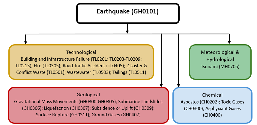
Multi-hazard context
The figure below summarises common interactions between earthquake and other hazards. This information should be used with caution and not be solely relied upon in Disaster Risk Management, particularly as some interactions may not have been included. Note that hazardous events occurring together or locally in space or time may not necessarily cause, amplify or be otherwise related to each other. Specific examples of multi-hazard context can be found in the ‘Hazard drivers’ and ‘Impacts’ sections above.
Multi-hazard diagram
Risk Management
Earthquakes cannot be prevented (and there is no technology to reduce their magnitude). However, earthquake-related vulnerability, exposure and hence risk can be reduced through proper risk reduction measures. These can include targeted seismic retrofitting interventions, the enforcement of modern design regulations, strategic urban planning (that forbids construction near cliff faces, active faults or on soft soils), and development of risk awareness campaigns.
The most common and effective measure for mitigating earthquake risk is the implementation and enforcement of building codes with provisions for earthquake safety. The US Federal Emergency Management Agency (FEMA, 2020) and the International Association of Earthquake Engineering (IAEE) provide online resources with Seismic Building Codes. Eurocode 8 is the reference European Standard that applies to the design and construction of buildings and other civil engineering works in seismic regions.
The Global Earthquake Model Foundation recently produced a global map of earthquake hazard and risk (Pagani et al., 2020; Silva et al., 2020) and is releasing the underlying national and regional models. Many of GEM’s hazard models have been developed by or in collaboration with national governments to provide a scientific basis for the development of seismic design codes.
Some success has been achieved in the development of early warning systems, which detect earthquakes close to the source or fault rupture, and trigger warnings to more distant locations, providing seconds to minutes of advance warning (Gasparini et al., 2007). Examples include the warning system for Japan’s bullet trains (Tajima and Hayashida 2018) and Mexico City’s warning system for evacuating occupants in vulnerable buildings (Suárez, 2022).
Monitoring
The section and the table below offer an overview of monitoring earthquake. This information can be used for forecasting within a national early warning system (EWS). Since EWS capacities and processes differ across countries, the most current and specific information regarding EWS should be obtained from the appropriate national or regional agency/authority responsible for disaster management.
| Which institution(s) produce(s) Disaster Risk Data/Information? | Earthquake Early Warning (EEW) systems, which trigger warnings of an earthquake in regions remote to the source, are maintained by the national organizations with the remit to monitor seismic activity (e.g., USGS for the United States). For some countries, some local/urban systems also exist that are maintained by the local government. |
| How is the Hazard Observed/Monitored/Forecast? | The effectiveness of EEW systems is highly dependent on the quality and density of seismic networks. It is fundamental to have seismic stations/sensors relatively close to the regions where earthquakes are expected to occur (e.g., active faults), to allow sufficient lead times. |
References
CRED, 2024. International Disasters Database of the Centre for Research on the Epidemiology of Disasters, available at: https://www.emdat.be/(Accessed on 15/05/2024).
Daniell, J.E., Schafer, A.M., Wenzel, F. ,2017. Influence of secondary hazards in earthquake loss, Frontiers in Built Environment. DOI: 10.3389/fbuil.2017.00030.
Dewey, J.W., Reagor, B.G., Dengler, L., Moley, K., 1995. Intensity distribution and isoseismal maps for the Northridge, California, earthquake of January 17, 1994. U.S. Geological Survey Open-File Report 95-92. doi: 10.3133/ofr9592.
FEMA, 2020. Seismic building codes. Last updated 13 October 2020. US Federal Emergency Management Agency (FEMA). www.fema.gov/emergency-managers/risk-management/earthquake/seismic-building-codes Accessed 9 December 2024.
Gasparini, P., Manfredi, G., Zschau, J. (eds.), 2007. Earthquake Early Warning Systems. Springer.
Grünthal, G. (ed), 1998. The European Macroseismic Scale EMS. www.gfz-potsdam.de/en/section/seismic-hazard-and-risk-dynamics/data-products-services/ems-98-european-macroseismic-scale Accessed 9 December 2024.
Hanks, T.C., Kanamori, H.,1979. A moment magnitude scale. Journal of Geophysical Research, 84: 2348-2350.
Pagani, M., Garcia-Pelaez, J., Gee, R., Johnson, K., Silva, V., Simionato, M., Styron, R., Vigano, D., Danciu, L., Monelli, D., Poggi, V., Weatherill, G., 2020. The 2018 version of the Global Earthquake Model: Hazard component. Earthquake Spectra, doi.org/10.1177/8755293020931866 Accessed 9 December 2024.
Silva, V., Amo-Oduro, D., Calderon, A., Costa, C., Dabbeek, J., Despotaki, V., Martins, L., Pagani, M., Rao, A., Simionato, M., Viganò, D., Yepes-Estrada, C., Acevedo, A., Crowley, H., Horspool, N., Jaiswal, K., Journeay, M., Pittore, M.,2020. Development of a Global Seismic Risk Model. Earthquake Spectra, doi.org/10.1177/8755293019899953.
Suárez G.,2022. The Seismic Early Warning System of Mexico (SASMEX): A Retrospective View and Future Challenges. Front. Earth Sci. 10:827236, doi.org/10.3389/feart.2022.827236.
Tajima F, Hayashida, T., 2018. Earthquake early warning: what does “seconds before a strong hit” mean?. Prog Earth Planet Sci 5, 63, doi.org/10.1186/s40645-018-0221-6.
UNDRR, 2015. Sendai Framework for Disaster Risk Reduction 2015-2030. United Nations office for Disaster Risk Reduction (UNDRR). www.undrr.org/publication/sendai-framework-disaster-risk-reduction-2015-2030 Accessed 18 January 2025.
USGS, no date a. Earthquake glossary. United States Geological Survey (USGS). https://www.usgs.gov/glossary/earthquake-hazards-program#E. Accessed 18 January 2025.
Wald, D.J., Lin, K., Quitoriano, V., 2008. Quantifying and Qualifying USGS ShakeMap Uncertainty: U.S. Geological Survey Open File Report 2008–1238, 26 pp.
Wood, H.O., Neumann, F., 1931. Modified Mercalli intensity scale of 1931. Bulletin of the Seismological Society of America, 21:277-283.