Reducing the risk of loss and damage in Mongolia

Mongolia has invested significantly in collecting local disaster losses and damages data for every hazard event, regardless of the size of its impact
The National Emergency Management Agency (NEMA) of the Government of Mongolia is responsible for collecting, storing, curating and sharing disaster loss and damage data on all small and large hazardous events. Guidance and templates for data collection on direct and indirect losses was issued in 2020 and data is collected at the local level by first responders as well as local government agencies. As much as possible, data is collected disaggregated by age, sex and disability, and by location based on existing administrative units, for five disaster classifications (geological, biological, fires, hydro-met and human-induced, which include explosions, mining accidents, or chemical spills and radiation). All raw data is shared with the National Office of Statistics, processed into official statistics and open to the public via a central portal.
The historical losses and damages data is used for the development of disaster risk reduction strategies, for disaster risk assessments and for preparedness planning. As Mongolia faces different types of disaster in each season, the data is used for seasonal preparedness and contingency planning, e.g. preparing rural communities for Dzud and snowstorms in winter or to plan for preventive action against flash floods and river floods in the summer. For example, data on livestock loss associated with Dzud was collected and shared with the United Nations agencies in the country in near-real time, resulting in a dashboard that was used by relevant actors during the last winter season enabling targeted early actions to be triggered and funded to prevent and reduce impacts for example preventive animal health and livestock management actions ( e.g. nutritional supplements, protective blankets for new-born animals, and destocking) to minimize livestock losses (see Figure 12) (OCHA, 2024 (b)).
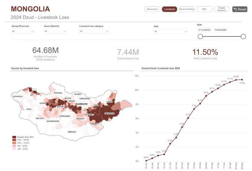

Livestock loss by soum (history)
Data on historical seasonal wildfire damage was used to determine most effective location of local fire-fighting units as well as of search and rescue branches. Loss and damage data from past disaster events also provide important information for the allocation of humanitarian assistance after a disaster as well as pre-positioning of relief support or identification of early action protocols. A Memorandum of Understanding with the National Statistics Office (NSO) ensures that NEMA shared locally collected data on a monthly basis, which is then also used for monitoring progress and reporting against the Sendai Framework and the SDGs.
Remaining challenges include the need for more capacity for local data collection and for ensuring other types of disaggregated data can be collected, such as income-related data. Also, the processes related to data collection, transfer, storage and curation - even within NEMA and
the NSO - need to be further established and improved, something that NEMA is keen on continuing to invest in in cooperation with its partners.
More effort in the curation of disaster loss and damage data for risk assessments is another area that the government is keen to develop further. This is understandable as national risk assessments and profiles, such as the country risk profile developed by the Central Asia Regional Economic Cooperation ( CAREC in 2022, still seem to be developed based on data from international databases such as EM-DAT rather than on nationally owned data.
Investments in this area could also contribute to existing initiatives, such as the PRISM platform. The PRISM platform was designed to make available climate hazard information, particularly Earth Observation data, which may not be easily accessible to countries with limited capacities and specialist expertise. The goal was to create actionable information for decision-making, using open-source software and as a digital public good, and making climate risk information available in a visually accessible format. In Mongolia, this WFP-led effort seeks to combine earth observation and climate data with data on disaster impacts. This would have the potential to significantly improve information on socio-economic vulnerability and thus contribute to more precise risk assessments and hotspot identification (Figure 13).
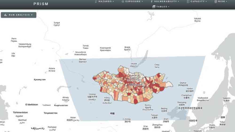
FIGURE 13: The PRISM Mongolia dashboard