Global Assessment Report on Disaster Risk Reduction 2015
Making development sustainable: The future of disaster risk management |
Global Assessment Report on Disaster Risk Reduction 2015
Making development sustainable: The future of disaster risk management |
|
|
70
Part I - Chapter 3
(Source: UNISDR with data from Global Risk Assessment.)
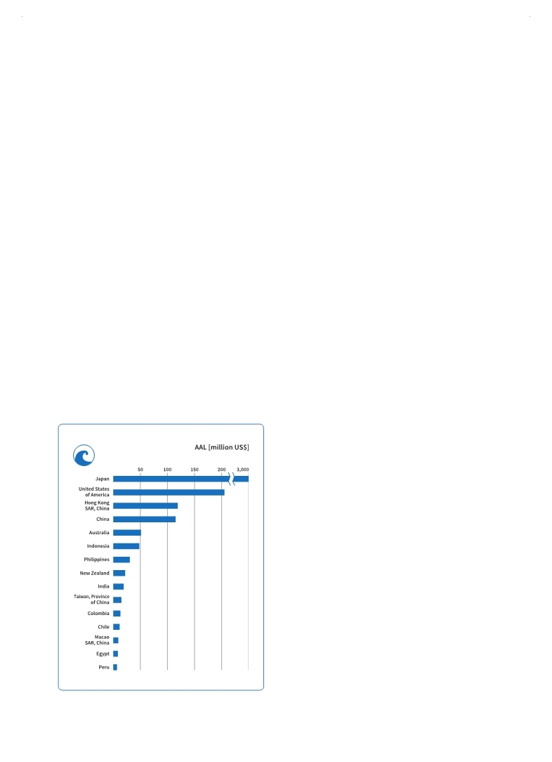
Figure 3.17 Top 15 countries: Tsunami AAL (excluding SIDS)
submarine landslide, which itself was triggered by an earthquake. In areas like eastern Indonesia (Lvholt et al., 2012 and 2014) and the Caribbean (Harbitz et al., 2012
Harbitz, C.B., S. Glimsdal, S. Bazin, N. Zamora, F. Løvholt, H. Bungum, H. Smebye, P. Gauer and O. Kjekstad. 2012,Tsunami hazard in the Caribbean: Regional exposure derived from credible worst case scenarios, Continental Shelf Research, Vol. 38, 15 April 2012: 1-23.. . In the open ocean, the speed of tsunami waves may exceed 970 km/h. Once tsunamis make landfall, wave heights may reach 30 metres above sea level or more. The speed and the distance that tsunami waves travel inland depends on the topography of the coastal area and land cover.21 The waves from the Tohoku tsunami of 2011 in Japan were as high as 10 metres and affected more than 400 km of coastline.22
Given that intense tsunamis completely destroy rather than damage physical assets in the proximity of the shore, tsunami risk is heavily influenced by exposure. This is reflected in the results
of the Global Risk Assessment, which show that tsunami risk is concentrated in a relatively small number of countries (Figure 3.17).
In terms of geographical regions, East Asia and the Pacific have the highest absolute tsunami AAL by far. Japan in particular has a far higher tsunami AAL than any other country.
As tsunami risk constitutes only a small portion of multi-hazard risk, it is not directly comparable to social expenditure or capital investment in either geographical regions or income groups.
However, the potential impact of tsunamis on the economy at the local, national, and even the global level cannot be ignored due to the cascading impacts that tsunamis can generate in countries where critical facilities such as nuclear power stations are located in coastal areas. This fact was highlighted by the Tohoku tsunami in 2011, which caused about US$130 billion in damage to buildings and total of US$210 billion in direct economic damage including infrastructure and the agriculture sector (GFDRR, 2012a
GFDRR (Global Facility for Disaster Reduction and Recovery). 2012a,The Great East Japan Earthquake: Learning From Megadisasters, Knowledge Notes. Executive Summary. The World Bank, Washington, D.C.. . River floods
Floods affect more people worldwide than any other hazard. There are many different manifestations of flooding, including flash floods, coastal flooding, surface water and ponding floods. In this analysis, flood risk23 is calculated only considering river flooding, and the measure of intensity used is the depth of the water. For frequent small-scale floods, risks can be estimated statistically using historical data, but for major floods a probabilistic approach is required.
|
 
Page 1Page 10Page 20Page 30Page 40Page 50Page 60Page 61Page 62Page 63Page 64Page 65Page 66Page 67Page 68Page 69Page 70Page 71->Page 72Page 73Page 74Page 75Page 76Page 77Page 78Page 79Page 80Page 81Page 82Page 83Page 84Page 90Page 100Page 110Page 120Page 130Page 140Page 150Page 160Page 170Page 180Page 190Page 200Page 210Page 220Page 230Page 240Page 250Page 260Page 270Page 280Page 290Page 300Page 310
|
|
 
|
 
|