Remote sensing could predict well water quality after floods
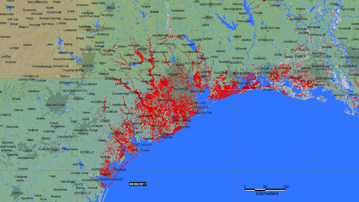
Hurricane Harvey flooded the U.S. Gulf Coast in 2017, and well water showed a marked increase in the presence of E. coli. Credit: G. R. Brakenridge and A. J. Kettner, “DFO Flood Event 4510,”/Dartmouth Flood Observatory, University of Colorado, Boulder, CC BY-NC-SA 4.0
More than 13 million U.S. households rely on private wells for their water supply. Unlike municipal water systems, which officials test and treat for contaminants, each well owner is responsible for their own water quality. There are no federal regulations and few, if any, state regulations governing private well water quality, even after water-contaminating floods.
Floods can pollute drinking water sources with fecal matter and other health hazards, and a study of private systems (mainly wells) in Virginia found that about 58% of more than 2,000 samples violated at least one standard required for municipal water systems. Yet there are few data to inform well owners when or whether testing is important after a flood.
Scientists from Northeastern University are devising a new approach to collecting detailed data about well users and their flood and health risks and will present their work on 16 December at AGU’s Fall Meeting 2021.
“What we’ve been concerned about is after a natural disaster, if there’s a big flooding event, what actually happens to these systems,” said Kelsey Pieper, an assistant professor in the Department of Civil and Environmental Engineering at Northeastern. “Do we even need to worry about private wells after flooding events, or are they fine?” Pieper and her team are combining remote sensing data, census demographics, flood hazard maps, and well water sampling data to answer that question and better inform disaster recovery efforts.
Testing the Waters
The last time the U.S. Census counted well owners was in 1990. Models from the U.S. Geological Survey and EPA predict that about 44 million people rely on privately owned wells, but without data on well use and ownership, recovery workers are blind as to which users are at risk of drinking contaminated water after natural disasters.
The Northeastern team is starting this new project to fill that gap, characterizing well ownership and the risk of well inundation during floods across the country. Elizabeth Bartuska, a Ph.D. student at Northeastern, has “been evaluating the potential for using remotely sensed data products to characterize flooding”—identifying where flooding occurs and how that correlates to satellite data. “We hope to integrate satellite observations into drinking water disaster recovery platforms to account for well users affected by natural hazards.”
Pairing that information with census data would also allow recovery workers to better target drinking water testing and treatment interventions. “Understanding who the population is helps you better understand how to help them recover from a disaster,” said Pieper.
This project builds on past work determining whether floods can be detrimental to well water. After Hurricane Harvey, Pieper and colleagues analyzed water samples from nearly 9,000 wells collected in the 10 months after the 2017 hurricane. The results, published in Environmental Science and Technology, showed that compared with estimated baseline contamination levels, rates of bacterial contamination with Escherichia coli and total coliform in private wells were 2.8 and 1.5 times higher, respectively. E. coli contamination was 8.5 times more likely when users reported that floodwaters submerged their wellheads.
Finding the Problem
One obstacle the researchers need to overcome is how to scale satellite data down to an actionable level. “Remote sensing data [are] usually at a very, very large scale, and we need to be at the household scale,” said Pieper. “How do you downscale data to make [them] useful?” The team is working on answering that question and figuring out how to give recovery workers actionable information.
Although this research could yield valuable information for disaster recovery workers about which wells may be submerged, it doesn’t account for all possible contamination sources. “When you have floods, the water can also get into the groundwater system through recharge,” said Kenneth Bradbury, the director and state geologist at the Wisconsin Geological and Natural History Survey. “If that’s the case, then just chlorinating the well isn’t going to solve the problem.”
But having the research to show that there is, in fact, a problem is the first step toward solving it. “If we don’t have the data to back that up, we don’t see the policy in place, and we don’t see the action,” said Pieper.