And suddenly the clouds ... the climate changes, the routes change

Sudden changes on weather in a very small area and particularly intense could seriously threaten the security of flights. To be able to predict these phenomena could save lives, and prevent damages on properties.
Thanks to research advances in the field of meteorology, we have accustomed to ever greater precision in forecasting atmospheric events. In addition to giving us the opportunity to better plan the weekend away, this type of forecast allows us to to perform safe activities and operations, and mitigate damage to infrastructures, properties and entire territories. But there are still difficulties, depending on the characteristics with which a violent storm can occur, suddenly and in a rather limited space. This is a real challenge for the scientific community, because these events are often characterized by huge amount of rain in a short period of time, by high lightning frequency in combination with large hail size, and very strong winds. In addition to the aforementioned damages to infrastructures, these phenomena are very dangerous for aviation safety, when aircrafts have to fly through or near these storms, and for the aviation management, because they threaten the flight safety, causing delays, cancellations, inconveniences and economic losses. As well as changes to airspace traffic, therefore addressing the problem at the international level is essential to have results with a measurable impact. You know, the skies have no borders. And due to global climate change, these phenomena occur more frequently over time and space.
For this reason, within SINOPTICA, an European research project funded by the Horizon2020 SESAR programme, CIMA Research Foundation (Interdepartmental Center for Environmental Monitoring), as project coordinator, the Universities of Padua and Barcelona, the German Aerospace Center (DLR), GReD (Geomatic Research and Development srl, spin off of Politecnico University of Milan), Austro Control (Austrian Air Navigation Service Provider) have combined their skills and various research expertises to implement hypotheses and case studies of meteorological forecasts related to airplane flights. In fact, there are areas in Europe where extreme and severe events are historically more frequent, but as we said due to the rapid climate change their frequency and intensity are increasing. We observe this in particular in the Italian Alpine area and in the Balkans.
In Figure 1, we see the trend of severe weather events in Europe. The darker the red, the more the severe weather tends to increase. Conversely the pale blue shows the trend is decreasing. So, you notice that Northern Italy is one of the “hot” areas in Europe. For this reason, Milan and Bergamo are two of the case studies that we have analyzed in SINOPTICA. The lightnings were used to identify severe weather.
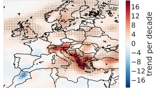
Figure 1. Trend of the annual number of severe weather events based with lightning (Radler, 2018, https://journals.ametsoc.org/view/journals/apme/57/3/jamc-d-17-0132.1.xml)
At European level, there is a high number of cyclones that hit the north-west coast and often these phenomena arise as tropical cyclones (hurricanes) which become extra-tropical, reaching latitudes (ours) still with great intensity, where in the past it was difficult for them to arrive. The "engine" of cyclones is the evaporation of the ocean that occurs when the water reaches or exceeds a certain temperature threshold. In the tropics, this happens quite easily because temperatures are higher, but in higher latitudes it is less likely because temperatures are usually lower. However, climate changes have led and are leading to an increase in air and water temperatures even in our latitudes and this causes storms in northwestern Europe, as proved by the passage of Hurricane Ophelia in 2017 which hit Portugal, Ireland and the United Kingdom. Ophelia is considered as the easternmost Atlantic hurricane ever recorded. In addition to cyclones, other severe weather events can form on the ground and are generally strong. Sudden and high intensity thunderstorms can also develop tornadoes. Tornadoes are very fast rotating columns of air formed at the base of storm clouds, which can cause harmful consequences for people and infrastructure.
In the near and not very distant future, Italy will be particularly exposed to severe weather events, especially in the northern regions (near the Alps) and near the coasts (Fig. 2). In October 2021, we had to familiarize ourselves with the Medicane – Mediterranean Hurricane – “Apollo” which caused extensive damage in Sicily and Calabria. The development of other Mediterranean cyclones can be foreseen, which are similar to the Atlantic hurricanes because of their intensity and structure. And just as dangerous being capable to achieve wind speeds up to 150 km/h (Category 1 hurricane) and to produce very intense and persistent lightning activity.
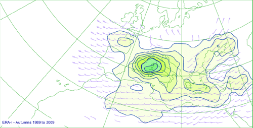
Figure 2. Density of cyclone tracks in autumn (Jansà, A., P. Alpert, P. Arbogast, A. Buzzi, B. Ivancan-Picek, V. Kotroni, M. C. Llasat, C. Ramis, E. Richard, R. Romero, and A. Speranza (2014). MEDEX: a general overview. Nat. Hazards Earth Syst. Sci., 14, 1965-198. doi:10.5194/nhess-14-1965-2014)
Extreme and severe weather can be dangerous for passenger and flight crews. Normally, the aircraft hull is resistant to lightning and strong winds. Hail, on the other hand, can cause considerable damage to wings, the radar dome at the nose of the aircraft and the cockpit windows. The greatest danger, however, is posed by sudden turbulences, which can hurl unbelted passengers and crew members through the aircraft and cause considerable injuries. These turbulences, also known as wind shear, also occur in the fringes of thunderstorm cells, which is why pilots are always advised to fly as far as possible around these areas.
Due to global warming, severe and extreme weather events and their associated phenomena tends also to increase and to appear at new locations as it has been shown in Figures 1 and 2. The project SINOPTICA deals with these meteorological events that sometimes develop quickly and over very limited areas. They are the most difficult events to predict, which cause increasing damages to aviation simultaneously.
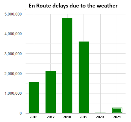
Figure 3. Accumulated minutes of en-route delay in Europe due to meteorological phenomena from 2016 to 2021 [Data source EUROCONTROL].
Figure 3 shows the delays accumulated in Europe due to the adverse weather only for the en-route phase of flights. In 2018 alone, more than 83 000 hours were lost for this reason. Figure 4 shows the relevance of weather delays compared to other reasons like capacity limits or disruptions for Italian airports. Usually about half of the accumulated delay is due to the weather conditions and in the seasons and months characterized by thunderstorm development, almost 100% of the delays is caused by these.
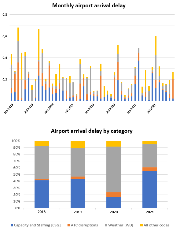
Figure 4. Delays in Europe due to various causes, in grey those due to weather events [Data source EUROCONTROL]
Today, especially at larger airports, controllers use air traffic control support systems to help them organize and guide arriving and departing traffic. However, these systems do not yet have the capability to use weather measurements or forecasts to calculate flight routes around thunderstorm areas. If extreme weather areas occur, the pilots decide on which side and at what distance they will fly around them. Controllers then have the task of supporting the pilots and avoiding separation infringements with other aircraft. Currently, they get no automatic support in these situations.
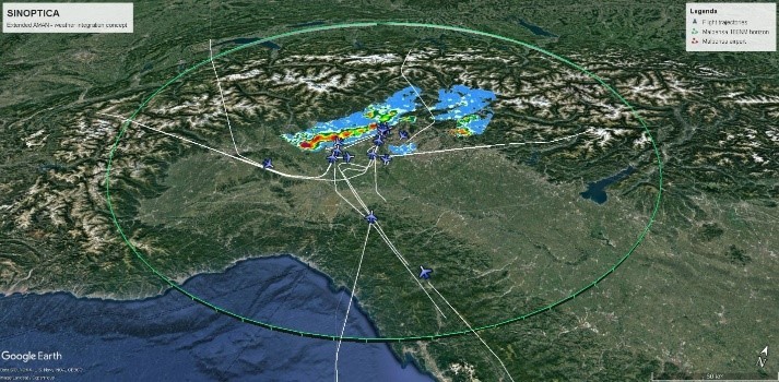
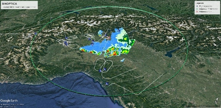
Figure 5. On 11.05.2019, suddenly occurring and fast-moving thunderstorms in the vicinity of Milano/Malpensa airport blocked huge parts of the airspace and force pilots and air traffic controllers to avoid and to fly around the most dangerous areas. Even before the airport was closed, delays were already being caused, which later increased significantly due to holding patterns.
In SINOPTICA, a module for an Extended Arrival Manager (Extended AMAN) system has now been developed that uses current weather information and forecasts from the project partners to plan the approaching traffic around the developing weather at an early stage. It is integrated directly into the working position of approach controllers and works seamlessly with existing systems. To achieve this, it is important that forecasts for the vicinity of airports can be produced with very high spatial and temporal resolution and precision, as SINOPTICA ensure.
The AMAN uses radar data and flight plans to assign every aircraft an arrival route, a runway and the landing time. In the case, a severe weather area blocks or will block the route, the AMAN calculates new approach routes around the dangerous areas with new arrival times and new positions in the actual landing sequence. The responsible controllers get advisories where and how long the aircraft have to leave the standard approach routes and on which target times they will be at the main waypoints of the route. Additionally, the systems allow controllers to fade in the predicted and animated severe weather areas. In this way, controllers are always informed about what is going on in the airspace and why the planning system suggests alternative routes.
In this way, the SINOPTICA project is helping to make air traffic safer, more reliable and more effective during approach in extreme weather situations.