By Angus Stevens, Technical Liaison and Data Analyst at Ambiental
Following a week of record-breaking temperatures, Northern England received a series of heavy rainfall events, culminating in the flooding of multiple areas in both the North West and the North East of England. We highlight the impacts of these floods and the solutions available to help mitigate the losses from future flood events for residents, asset managers and insurers alike.
What has been the impact so far?
Damage to infrastructure and properties occurred in North Yorkshire, Derbyshire and in areas surrounding Stockport. Roads and rail lines were also affected by flooding leading to road closures and train cancellations.
Near to the village of Grinton, North Yorkshire, a bridge collapsed due to the strong floodwaters generated by the heavy rainfall, making the road unpassable. Another road in the Grinton area was also heavily damaged due to floodwaters undermining the ground beneath the road.
On the other side of Northern England in Stockport, the A555, a newly constructed stretch of dual carriageway, was closed due to an accumulation of surface water causing local disruption. Stockport also suffered property damage in the Bramhall and Norbury Moor areas. In the Norbury Moor area several properties including a primary school were flooded, causing damage.
The Derbyshire town of Whaley Bridge has been evacuated due to the Toddbrook Reservoir Dam becoming damaged. The damage is thought to have been caused by the high levels of rainfall in the area. Emergency services have been on hand to pump water out of the reservoir and evacuate the town. The armed forces were deployed to aid with the emergency repairs to the dam.
Many links have been made to climate change as a causing factor of these flooding instances. With future climate change expected to increase the frequency and intensity of flood events, the United Kingdom must be prepared to manage and mitigate flood risk in order to limit disruption and potential loss of life.
Analysing the impact
After flood events such as these, we extensively scrutinise our data against the images captured at the scene and against any data that is issued from the Environment Agency.
Below is an image taken on an overpass over the A555 in Stockport, the image shows both lanes are flooded up to the beginning of the bend in the road. The right-hand image displays Ambiental’s UK FloodMap™ data for the same location. The modelled flood water is indicated in blue and shows a good correlation to the flood event photograph.
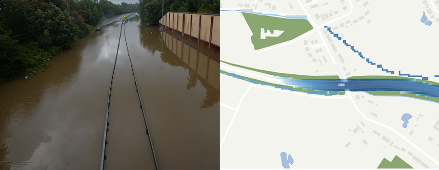
Source: Press Association Map showing UK FloodMap 4 data and based on Ordnance Survey Zoomstack
Surface water (pluvial) flood events have the potential to be highly dangerous and disruptive when flood water accumulates on roads. The impermeable surfaces that are used to create highways ensure that roads are more likely to experience flooding from surface water flood events such as this. Even where drainage systems exist, there are frequent occurrences of drains becoming overwhelmed by extreme amounts of rainfall. Given that flood events are expected to increase in frequency and intensity, it becomes almost imperative that transport authorities have the knowledge of where to target future resources to reduce the effects of flooding.
We also conducted analysis of another flooded location in Poynton, Cheshire. The left-hand image below displays an aerial photograph of a flooded area in Poynton, that we compared to our UK FloodMap 4 data (Right-hand image). For ease of comparison we have referenced the two buildings that are being analysed in both images. It can be seen that the car park attached to building 1 has partially flooded, with our UK FloodMap 4 data identifying a similar flood extent and comparing well to the aerial image. Building 2 and the surrounding access roads are shown in both images to be flooded.
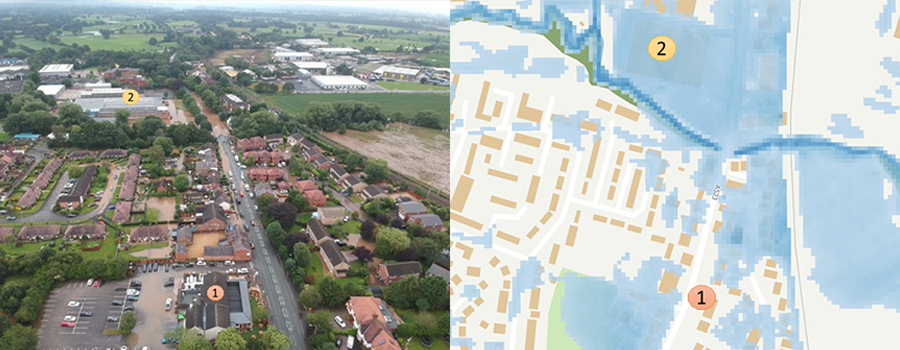
Source: James Hanson Map showing UK FloodMap 4 data and based on Ordnance Survey Zoomstack
Implications for future flooding
Over recent years, there has been an increased trend in flash flood events in the UK, triggered by extreme rainfall. These occurrences have been strongly linked to climate change, with climate change having the potential to intensify and increase the frequency of surface water flooding events in the future. As outlined by the Environment Agency, it is therefore apparent that the UK must increase its resilience to flooding to reduce the need for costly evacuations and emergency repairs and to limit the disruption caused by the occurrence of these kinds of surface water flood events. Ambiental’s FloodFutures® modelling has been specifically designed for insurers, lenders and property/infrastructure asset managers to assist with long term planning for resilience against future flooding risks.