
Japan has seen an increase in extreme rain events in recent years, resulting in catastrophic flooding with substantial loss of human life and destruction of property. As climate change is likely to increase the severity and frequency of flooding, governments and other organisations are rightly becoming more concerned. Research conducted by Shakti P.C. and colleagues at Japan’s National Research Institute for Earth Science and Disaster Resilience (NIED) aims to improve our understanding of unpredictable flood processes, monitor them, and mitigate their impacts. P.C.’s research uses flood inundation mapping, hydrological modelling, and other advanced techniques to improve flood resilience.
Torrential rain and associated flood disasters have been one of human history’s most deadly and costly natural disasters around the world. As humans have moved into increasingly large cities and urban sprawl has pushed communities into flood-prone areas, the problems associated with flooding have become more pronounced.
The recent rise in destructive flooding and the anticipated increase in extreme rain events has raised the concern of governments, and many national and international research organisations are working to advance our understanding of these phenomena and how best to mitigate their effects.
Shakti P.C. and his team at the Storm, Flood, and Landslide Research Division, National Research Institute for Earth Science and Disaster Resilience (NIED), Japan, are using their experience of extreme flood events to make predicting and managing catastrophic floods easier. In their timely and essential research, P.C. and his team have conducted multiple studies using the most up-to-date technology to find effective ways of using flood inundation modelling, flood-risk assessments, hydrological modelling, and more.
Flooding in the remote mountainous upstream side of river basins – where real-time observation of river runoff is difficult – heavily influences sudden flooding downstream. Therefore, P.C. and his team had to develop bespoke methods of assessing and observing remote upstream river basins to get a full understanding of the flood dynamics of upstream and downstream river basins after torrential rain.
Creating better models to understand where and when flooding will occur enables better adaptation and mitigation.
The result of P.C.’s research will enable planners, government officials, engineers, and the public in Japan and around the world to predict where flooding will occur, how to mitigate flood damage, and how to manage floods in real-time.
Flooding in Japan
Japan is no stranger to flooding due to the long typhoon season characterised by multiple extreme rain events. But recent years have seen an increase in the number and severity of extreme rain events, and annual flood-damage costs and loss of life have been increasing each year as a result.
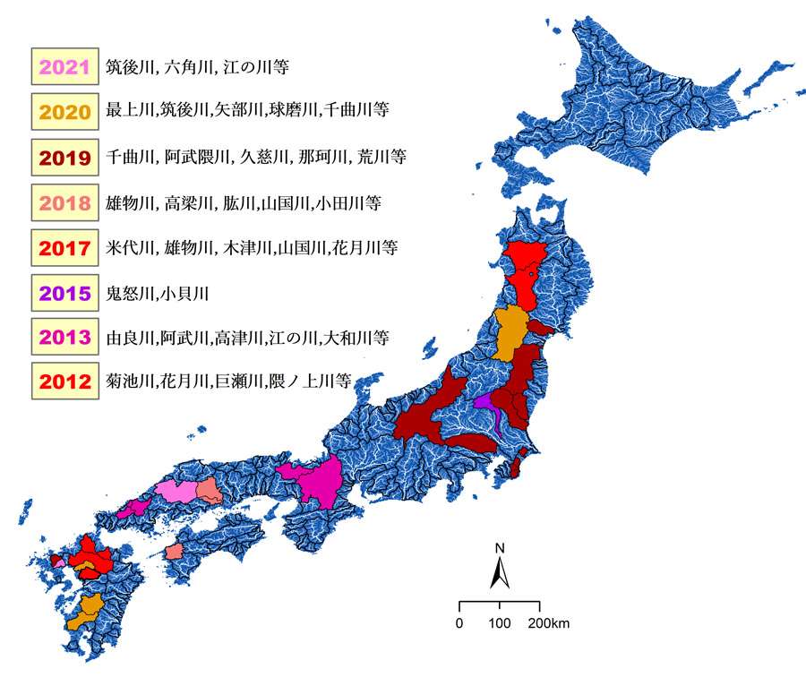
The examples are plentiful and unrelenting. A heavy rainfall event in July 2012 caused severe flooding in many small river basins in the Northern Kyushu region and resulted in extensive damage to agricultural land and several houses. Extreme rainfall over the Kanto region in 2015 caused heavy flooding across the Kinugawa River Basin and resulted in fatalities and damage to property. An event on July 5–6, 2017, caused significant flooding in many river basins in Northern Kyushu. The flooding resulted in a significant number of fatalities and property damage. On July 5–8, 2018, torrential rain caused heavy flooding in the Oda river basin, causing severe flood inundation in the Mabicho region of the basin which resulted in significant loss of life and severe infrastructure damage. On October 1–13, 2019, heavy flooding in many river basins in the central-northern region of Japan caused significant loss of life and damage to property. And in the first week of July 2020, heavy rain caused flooding in the southern Japanese island of Kyushu. These events indicate a worrying trend: the damage and associated cost following each event has been increasing. The extent of each flood can be seen on the map in the Figure 1.
Accounting for climate change
Based on trends of such recent events, it appears that flood disasters caused by extreme rainfall may increase in the coming years. Analyses of historical flood data and recent flood events in mountainous regions of Japan clearly demonstrate that large areas of the country have frequently been affected by floods caused by heavy rain. Moreover, based on the projection of climate change for varying scenarios and simulations, there is a possibility that the frequency of extreme rain and associated flood events will increase in coming years across Asia.
According to an analysis by Li and Otto (2022), the devastating flooding in northern central Japan in 2019 caused by Typhoon Hagibis was made 67% more likely by climate change. The same analysis attributed $4 billion of the $10 billion in damages caused by the extreme rain event and subsequent flooding to man-made climate change. Events like this show that climate trends are an important consideration in future flood planning.
Modern methodologies to address flood risk
As the economic and social costs of flooding grow in a changing climate, timely and accurate flood data is essential to improve flood risk resilience and adaptation. With the array of technology at their disposal, P.C. and his team at NIED have developed a comprehensive flood disaster prevention and management framework.
Improving flood-risk resilience requires in-depth observations from real-time radar rainfall monitoring and hydrological studies of rivers. Data taken from local social media content and remote sensing equipment also contribute to the creation of real-time flood inundation maps. Combined with future climate scenarios and land-use data, this increases real-time flood-risk resilience and future adaptations. The NIED has developed a series of tools and methodologies to collect all relevant data to make a comprehensive framework for building accurate real-time flood models. These include:
- A technique for assessing the geometry of a river basin, which significantly impacts the hydrological response of a river to extreme rain;
- The rapid-flood inundation mapping product: a flood-inundation tool based on surveying the extent of previous floods which can give real-time flood depth marks in a flooded area;
- A tool to quickly estimate the status of the built environment in an area, to understand what dwellings and critical infrastructure may be at risk during a flood event;
- The world’s largest rain simulation facility (Figure 2) which elucidates how extreme rain events create sediment problems, such as in landslides, erosion, and flood hydrology;
- A methodology for using a high-sensitivity seismograph network (Hi-net) to identify the time and peak of water flow in remote ungauged mountainous rivers during heavy rains. This information is essential for understanding flood risks in river basins during extreme rain events.
Shakti P.C. and his team at NIED have developed a comprehensive flood-disaster prevention and management framework.
Combining these tools gives town planners, engineers, policymakers, and the public substantial insights to make data-driven decisions. Additionally, P.C. and his team are continually building on their process, making new tools and methodologies to create an ever-more comprehensive framework for flood disaster prevention and management. This includes the creation of digital twins (virtual representations of cities or other regions and the flood management systems they have in place) to improve the flood resilience of cities and infrastructure in the future. All the above-mentioned approaches will contribute to these developments.
Flood resilience management and prediction and action
P.C. and his team at the NIED have already successfully improved our understanding of flood processes, monitoring, and analysis through multiple pieces of research and case studies. One of these concerns flood inundation mapping of the 2019 event in North Central Japan (Hitachi region), related to the Hagibis Typhoon. The research enabled them to map the greatest possible extent of flood inundation across the whole river basin. They achieved this through a mixed methodology of remote sensing, post-flood field surveys, identifying embankment failures, and conducting hydrological simulations under different embankment failure scenarios. This event-specific research will enable the team to produce even better mapping products to help improve planning and management of future extreme flood events in this area.
Another of the team’s case studies showcased and optimised their tool for estimating the status of a city’s land-use profile, its buildings and road networks throughout a flooding event. The study took place in Hitoyoshi City of Kumamoto Prefecture, Japan, during the first week of the area’s July 2020 floods. The tool enabled emergency responders and local government to quickly assess the exposure of critical infrastructure and human habitation to the flood, making it easier to evaluate and respond effectively. The case study determined the percentages of urban, agricultural, and forest areas affected by the flood, revealing that 5,355 buildings were inundated, and 24% of those buildings were exposed to over two metres of flooding, indicating the highest level of danger (Figure 3). This information will help with real-time flood management, inform future emergency response, and help planners and policymakers understand where to safely position critical infrastructure. This case study will apply to every Japanese city and others worldwide for effective flood-risk response.
As just two examples of the many essential research articles and case studies P.C. and the team at NIED have conducted, these studies demonstrate how the outcomes of their research will be integral in contributing to the practice of flood resilience. It will also improve Japan’s town planning and contribute to policies that adapt to current and future catastrophic flooding events caused by extreme rain. P.C.’s work will be applicable globally as climate change brings more frequent, unpredictable, and severe rain everywhere. The team at NIED plan to conduct collaborative research with international universities, companies, and research institutions to further the development and impact of their work and equip countries around the world with the best possible tools and methods to mitigate and adapt to flood-related risks.
Personal Response
Could the tools and methodologies you have developed also be effective in predicting and managing flood-related sea-level rises?
All the developed tools and methodologies can be a useful reference for the warning, response, mitigation, and evaluation process. To improve methods and tools for specific purposes, further research will be performed in the future. There are some promising and important proposals for flood disaster prevention and management during heavy rain events, which are based on interdisciplinary subjects and will be actively promoted going forward. Further collaboration at national and international level will certainly enhance our research. Sharing experience on flood disasters will help us to tackle this problem globally.
Finally, research on extreme rain events and associated floods needs to consider our future climate so that we can enhance flood resilience and adapt to a changing environment.