Ten years on from the quake that shook the nation’s capital
Ten years ago, early in the afternoon of 23 August 2011, millions of people throughout eastern North America—from Florida to southern Canada and as far west as the Mississippi River Valley—felt shaking from a magnitude 5.8 earthquake near the central Virginia town of Mineral [Horton et al., 2015a]. This is one of the largest recorded earthquakes in eastern North America, and it was the most damaging earthquake to strike the eastern United States since a magnitude 7 earthquake near Charleston, S.C., in 1886. Considering the population density along the East Coast, more people may have felt the 2011 earthquake than any other earthquake in North America, with perhaps one third of the U.S. population having felt the shaking.
The earthquake caused an estimated $200 million to $300 million in damages, which included the loss of two school buildings near the epicenter in Louisa County, substantial damage 130 kilometers away at the National Cathedral and the Washington Monument, and minor damage to other buildings in Washington, D.C., such as the Smithsonian Castle. Significant damage to many lesser-known buildings in the region was also documented. Shaking led to falling parapets and chimneys, although, fortunately, there were no serious injuries or fatalities. Rockfalls were recorded as far as 245 kilometers away, and water level changes in wells were recorded up to 550 kilometers away.
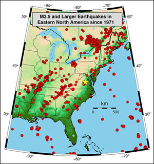 Fig. 1. Red dots denote epicenters of earthquakes of magnitude 3.5 or greater recorded since 1971 and indicate that earthquakes occur across large areas of eastern North America. The epicenter of the 2011 Mineral, Va., event is shown by the yellow star. Credit: USGS |
The intraplate Mineral earthquake (meaning it occurred within a tectonic plate far from plate boundaries) is the largest eastern U.S. earthquake recorded on modern seismometers, which allowed for accurate characterization of the rupture process and measurements of ground shaking. Technologies developed in the past few decades, together with an evolving understanding of earthquake sources, created opportunities for comprehensive geological and geophysical studies of the earthquake and its seismic and tectonic context. These research efforts are providing valuable new understanding of such relatively infrequent, but damaging, eastern North American earthquakes (Figure 1), as well as intraplate earthquakes generally, but they have also highlighted perplexing questions about these events’ causes and behaviors.
Revealing New Faults
The Central Virginia Seismic Zone has a long history of occasional earthquakes [Chapman, 2013; Tuttle et al., 2021]. The largest recorded event before 2011 was an earthquake that damaged buildings in and near Petersburg, Va., in 1774, but larger events are evident in the geologic record from studies of ground liquefaction. These are natural earthquakes, with no evidence that they are caused by human activity such as injection or withdrawal of fluids in wells.
Postearthquake studies of the area around the Mineral earthquake’s epicenter involved geologic mapping, high-resolution topographic mapping with lidar, airborne surveys of Earth’s magnetic field, seismic methods to examine subsurface structure, and detailed examination of faults using trenching. The earthquake began about 8 kilometers underground on a northeast–southwest trending fault that dips to the southeast. The rupture progressed upward and to the northeast across three major areas of slip [Chapman, 2013], thrusting rocks southeast of the fault upward relative to rocks to the northwest, although the fault rupture did not break the surface. This previously unknown fault has been named the Quail fault [Horton et al., 2015b].
The relationship between the Quail fault and ancient faults in the region is debated. The simple hypothesis is that the many faults along which modern earthquakes concentrate represent long-term zones of weakness. However, over their long geologic history, some of these old faults have gone through metamorphic events, in which exposure to high pressures and temperatures may have hardened or healed the faulted rocks. Magnetic data collected after the 2011 earthquake are consistent with rocks having different magnetic properties on each side of the Quail fault, suggesting the earthquake ruptured an older fault juxtaposing different rock types [Shah et al., 2015]. Yet a corresponding fault is not apparent in seismic reflection data from several kilometers south of the earthquake, indicating either that the fault terminates not far south of the 2011 epicenter or that there is a different explanation for the magnetic anomalies [Pratt et al., 2015].
As with faults associated with many earthquakes in eastern North America, the Quail fault does not appear to extend upward to any previously mapped faults at the surface, making past ruptures on such faults difficult to study. Clearly, there is still much to learn about the complicated relationships between modern seismicity and the locations and orientations of older intraplate faults, raising questions about the common assumption that future earthquakes will reactivate older faults and creating uncertainties in regional hazard assessments.
Shaking Eastern North America
The crust of the eastern North American plate is older, thicker, colder, and stronger than younger crust near the plate’s active margins, allowing efficient energy transmission that results in higher levels of shaking reaching much greater distances than is typical for earthquakes in the western part of the continent. Such intraplate settings also cause earthquakes to be relatively energetic (with high “stress drop”) for their size [McNamara et al., 2014a; Wu and Chapman, 2017], which results in relatively high frequency shaking that can cause strong ground accelerations and damage to built structures. The strong accelerations from the Mineral earthquake, for example, caused a temporary shutdown of the reactors at the North Anna Nuclear Generating Station in Louisa County, although damage was minimal.
Within minutes of the Mineral earthquake, it was evident that the event had the largest felt area of any eastern U.S. earthquake in more than 100 years. The U.S. Geological Survey (USGS) Did You Feel It? (DYFI?) website, where people can report and describe earthquake shaking, received entries from throughout the eastern United States and southeast Canada (Figure 2). Seismometers indeed showed ground shaking extending to far greater distances than for similarly sized earthquakes in the western United States, as had been observed in smaller earthquakes. These seismic readings provide an important data set for accurately determining the attenuation of seismic energy with distance across eastern North America, which is valuable information for estimating potential extents of damage in future earthquakes.
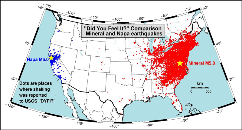
Fig. 2. Comparison of felt reports in the USGS Did You Feel It? (DYFI?) system from the 2011 Mineral earthquake and the similarly sized 2014 Napa earthquake in California. Shaking during the Mineral earthquake was reported over a much larger area. Considering the modern population density in the eastern United States, the Mineral earthquake was probably felt by more people than any other earthquake in U.S. history. Credit: USGS
Ground shaking during the Mineral earthquake was decidedly stronger to the northeast of the epicenter [McNamara et al., 2014b]. This variation with azimuth was found to be mostly due to the more efficient transmission of energy parallel to the Appalachians and the edge of the continent, indicating the strong influence that crustal-scale geology has on ground shaking. A similar pattern was recently seen in the magnitude 5.1 Sparta, N.C., earthquake in 2020.
Also notable during the Mineral earthquake was the enhanced strength of shaking in Washington, D.C., which was quickly recognized in the DYFI? reports [Hough, 2012]. This localized area of stronger shaking was primarily caused by amplification of seismic energy in the Atlantic Coastal Plain sediments that underlie much of the city. Seismometer recordings and modeling of ground shaking using soil profiles have shown that this effect can be severe in the eastern part of the continent where the transition from extremely hard bedrock to soft overlying sediments amplifies shaking and efficiently traps seismic energy through internal reflections in the sediments [Pratt et al., 2017]. Similar amplification effects by sediments have concentrated damage in other earthquakes, for example, in the Marina District of San Francisco during the 1989 Loma Prieta earthquake and in Mexico City during the 1985 Michoacán earthquake.
The large amplification during the Mineral earthquake by the Atlantic Coastal Plain sediments, which cover coastal areas from New York City to Texas, has given impetus to recent studies characterizing how this effect is influenced by sediment layers of different thicknesses and different frequencies of shaking. Personnel from the USGS National Seismic Hazard Model project are evaluating results from these studies for production of more accurate national-level hazard maps on which many building codes are based.
Renewed Interest in Intraplate Earthquakes
Earthquakes within plate interiors generally receive less attention than the more frequent events at active plate boundaries, including those of western North America. With its extensive affected area, the Mineral earthquake led to increased interest in the causes of intraplate earthquakes. Earthquakes at plate boundaries occur largely because of differential motion between adjacent plates. Earthquakes within relatively stable tectonic plates are more difficult to understand. Hypotheses to explain their occurrence include plate flexing due to long-term glacial unloading (melting) or erosion of large areas of rock and sediment, drag caused by mantle convection below a plate, residual tectonic stress from earlier times that has not been released, gravitational forces caused by heavy crustal features such as old volcanic bodies, and stress transmitted from plate edges. The question of what causes these earthquakes remains unresolved, and the answer may differ for different earthquakes.
Studies of the Mineral earthquake have offered new understanding and insights into intraplate earthquakes, such as the behavior and duration of aftershock sequences following eastern North American earthquakes. Portable seismometers deployed following the earthquake were used to identify nearly 4,000 aftershocks in the ensuing months [McNamara et al., 2014a; Horton et al., 2015b; Wu et al., 2015]. Of about 1,700 well-located aftershocks, the majority occurred in a southeast dipping zone forming a donut-like ring around the main shock rupture area. The aftershocks show a variety of fault orientations over a relatively wide area, indicating rupture of small secondary faults. Aftershocks from the Mineral earthquake continue today, providing information to better forecast aftershock probabilities and durations in future eastern North American earthquakes.
Detailed geologic studies of the earthquake’s epicentral region also led to the recognition of fractures, or joints, in the bedrock that trend northwest–southeast. These joints have orientations similar to some of the fault planes determined from aftershocks but significantly different from the main shock fault plane. This observation indicates that some aftershocks are occurring on small faults trending at sometimes large angles to the Quail fault, with some being parallel or nearly parallel to Jurassic dikes mapped in the region. These aftershocks and joints are indicative of the influence of older deformation of multiple ages on modern seismicity.
Although seismometers throughout the region provided important recordings of ground motions during the Mineral earthquake, the earthquake was also a “missed opportunity” for studying infrequent intraplate earthquakes because of the relatively small number of seismometers operating in the eastern United States at the time. Far more information could have been obtained had there been more instruments, especially near-source instruments to record strong shaking. To increase the density of seismometers in the central and eastern United States and prepare for studies of future earthquakes in the region, in 2019 the USGS assumed operations of the Central and Eastern United States N4 network, comprising stations retained from the EarthScope Transportable Array.
Reminder of Risk
 Scaffolding was erected around the Washington Monument, seen here from inside the Lincoln Memorial, to help repair damage caused by shaking from the 2011 earthquake. Credit: Thomas L. Pratt |
he Mineral earthquake offered a startling reminder for many people that eastern North America is not as seismically quiet as it might seem. Damaging earthquakes off Cape Ann, Mass., in 1755 and near Petersburg, Va., in 1774 demonstrated this fact more than 2 centuries ago, and the 1886 Charleston earthquake showed just how damaging such events can be. Recent events, including the recent magnitude 4.1 earthquake in Delaware in 2017 and the 2020 Sparta, N.C., earthquake, have shown that earthquakes can still strike unexpectedly across much of the eastern United States (Figure 1).
Geologic evidence of large earthquakes in the ancient past in eastern North America is clear. A magnitude 6 to 7 earthquake, likely in the past 400,000 years, ruptured a shallow fault beneath present-day Washington, D.C., for example, with the fault now visible in a road cut near the National Zoo.
In any given area of the eastern United States, however, these damaging earthquakes are infrequent on human timescales and are commonly followed by decades of quiescence, so their impacts tend to fade from memory. Nonetheless, such earthquakes can cause severe and widespread damage exceeding that from more frequent severe storms and floods. Also, unlike many natural hazards, earthquakes provide virtually no advance warning. Even if an earthquake early-warning system like that operating along the West Coast is eventually installed in the central and eastern United States, there would be, at most, seconds to tens of seconds of notice before strong shaking from a large earthquake.
The rarity of earthquakes in central and eastern North America presents challenges for studying their causes and effects and for planning mitigation efforts to reduce damage and loss of life in future earthquakes. Yet the potential consequences of not taking some mitigation measures can be extreme. Many older buildings across this vast region were constructed without regard for earthquakes, with unreinforced masonry buildings being particularly vulnerable. These older construction practices, combined with the high efficiency of energy transmission and potential local amplification of ground shaking by sediments, create potential risk for eastern North American cities to sustain extensive damage during an earthquake.
For example, damage seen in Washington, D.C., from the Mineral earthquake shows that a repeat of the ancient magnitude 6 to 7 earthquake on a fault directly beneath the city would be devastating to the city and could severely affect federal government operations. The last earthquake on the fault beneath D.C. is thought to have occurred tens to hundreds of thousands of years ago—that is, in the geologically recent past—suggesting the fault could still be active. Its next rupture may not occur for thousands of years or more, yet there is also the remote chance that it could happen much sooner.
The Mineral earthquake showed clearly that seismic risks in eastern North America cannot be ignored, as there will inevitably be more earthquakes that cause damage in this part of the country. It was only in the second half of the past century that probabilistic seismic hazard assessments, like the U.S. National Seismic Hazard Model, were developed to quantify the ground shaking that buildings may experience in a given time frame. These shaking forecasts provide guidelines for constructing buildings and other infrastructure to suitable levels for seismic safety.
Retrofitting vulnerable structures and raising awareness of the earthquake risks—and of simple, inexpensive mitigation actions like keeping an emergency preparedness kit on hand and making contingency plans (e.g., for family separations)—are important societal steps to help safeguard the population. Meanwhile, continued scientific research that builds on the work done since the Mineral earthquake and explores past and present earthquakes elsewhere in eastern North America will improve seismic hazard assessments to better estimate and mitigate ground shaking expected during earthquakes to come.