What are we orbiting towards? Evolution of the satellite industry to better manage complex risks

Satellite technology applications for disaster and climate risk management have transformative humanitarian-development potential; now and in the years to come. World Humanitarian Day, celebrated globally on 19 August, acknowledges the climate crisis as a critical driver that amplifies the risks faced by vulnerable peoples worldwide, especially in humanitarian crises. Technology is valuable for emergency preparedness and response, providing insights and granularity for unpacking disaster vulnerability and hazard exposure. These applications are also essential for realizing the 2030 Agenda for Sustainable Development, which seeks to leave no one behind in achieving inclusive global development.
Section I: Characterising and monitoring the environment and populations in disaster and climate ‘hotspots’
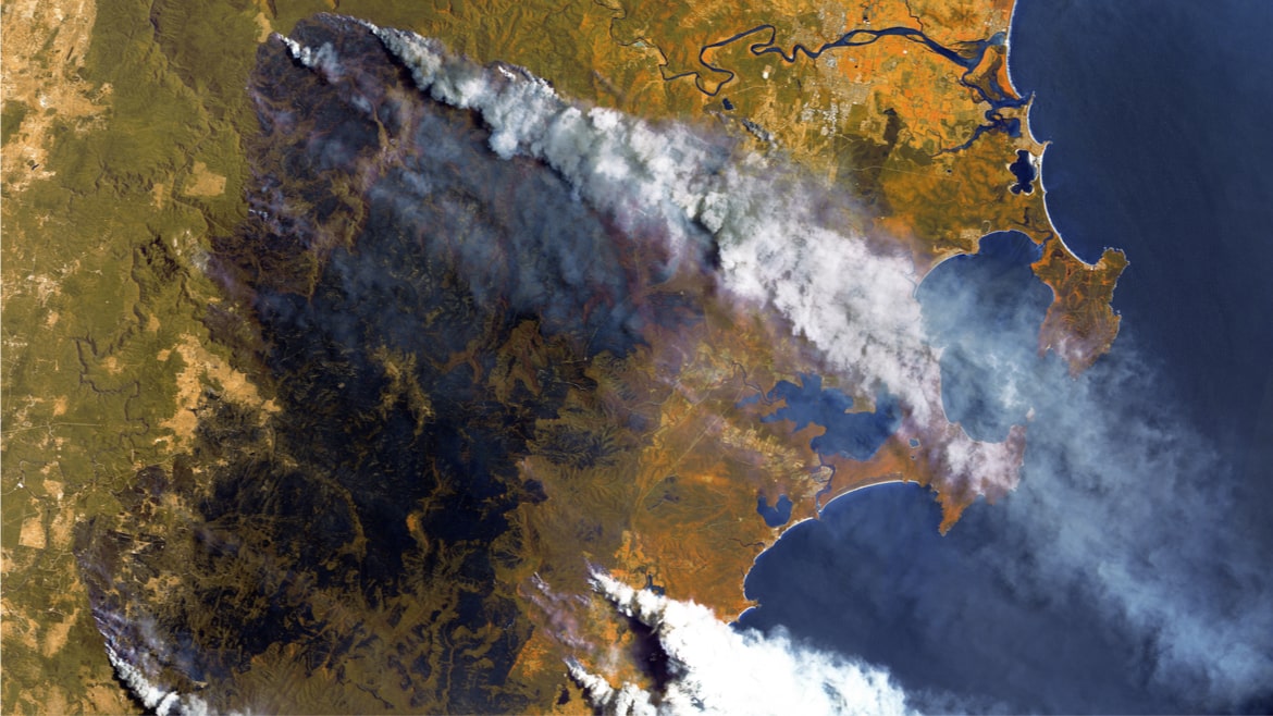
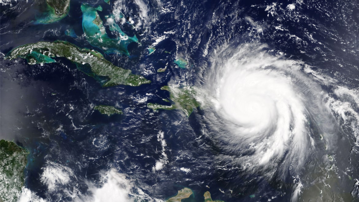
Disasters cause tremendous socio-economic disruptions, often affecting large areas, in a fell swoop. Moreover, the strength and intensity of disasters are being amplified by a changing climate. Collecting continuous data on disasters by using conventional methods is no longer an easy task. However, space technology and remote sensing tools offer practical possibilities to this data - aggregating reliable information at global and regional scales quickly and repetitively, in secure digital formats.
Satellites and remote sensing techniques can be used to monitor a disaster situation - before, during, and after the event- providing valuable baseline data against which future changes can be measured. Geographic Information System (GIS) remote sensing approaches utilize satellite imagery, Global Positioning System (GPS) recordings, and textual attributes associated with a space, thereby integrating and analyzing many types of data sources required for disaster monitoring. For example, the Disaster Monitoring Constellation (DMC) is a unique Earth observation satellite constellation, delivering high-frequency imaging anywhere on the globe from a long-established collection of satellites.
Satellite technologies also have critical early warning applications. Detecting where growing population concentrations are, especially the more vulnerable (e.g., in hazard-exposed coastal zones), in disaster ‘hotspots’ and characterising their physical exposure represent fundamental inputs for both disaster and climate risk assessments. For example, the Pacific Tsunami Warning System is satellite-based, relying on timely and reliable data gathered from buoys at sea or tidal gauges in ports, and subsequently transmit data to warning centres.
Section II: Emergency response insights to ‘build back better’
International cooperation is most valuable for recovery needs, and planning recovery measures in post-disaster situations. Demonstrating this, the International Charter: Space and Major Disasters is a worldwide collaboration, whereby satellite data is made available for disaster management and risk reduction insights. Through combining Earth observation assets from different space agencies, the Charter allows resources and expertise to be coordinated for rapid response to major disasters. Activated by the Emergency Telecommunications Cluster, the Crisis Connectivity Charter is another key international initiative, which is built on principles to improve existing satellite-based response and enhance connectivity in crises.
Another example of a similar collaborative vein, the European Commission, the United Nations Development Group and the World Bank established a partnership platform to strengthen coordination for early response capacities, and for recovery planning. A multi-stakeholder post-disaster needs assessment (PDNA) recovery framework for decision-makers - to be used during the early phases of disaster recovery planning - was adopted. Therefore, PDNAs typically inform national recovery plans after a disaster strikes, and therefore are essential for longer-range resilience building.
Whilst satellites have traditionally been used more for predictive applications related to disaster risk management, their value in informing emergency response cannot be underscored. The European Union’s Copernicus Emergency Management Service provides access to free satellite data during response to major disasters. Copernicus produces reference maps for comprehensive and updated knowledge of the territory and relevant assets, as pre- and post-disaster situation maps.
Space technologies are driving decisions made by the public and private sectors alike. So what direction is the satellite industry moving to?
Section III: Evolution of satellite technology to meet current risks
Nowadays, there is an urgent need to switch to more innovative and agile approaches to observe the environment and monitor population distribution. This trend is reflected in more performing platforms and more accurate, repeatable, and frequently updated data acquisition and processing solutions. In this scenario, constellations of small satellites - with their ability to provide frequent coverage and/or repeat measurements – are satellite industry’s future. Indeed, the trend towards smaller satellites has not only reduced the costs of building, launching, and operating satellites, but has also enabled faster and more flexible deployment, and made satellite mega-constellations feasible.
More and more private and public players in the space sector are planning to launch and operate swarms of small satellites in the coming years. By 2030, estimates show that this number could rise up to 100,000, due to missions such as SpaceX's Starlink or Amazon's Kuiper constellations aiming at delivering Internet access to remote places. As you can imagine, global Internet coverage has manifold implications for disaster risk management, especially when land-based telecoms networks are down.
Earth observation satellites are mainly located in the so-called Low Earth Orbit (LEO), providing global coverage with comparatively low temporal - but medium to very high spatial - resolution, depending on the on-board instrument and mission objectives. A LEO constellation with enough satellites and the proper instrument could ensure the required operations, communications, and monitoring up to a 24/7 basis at every point on the planet. For example, the Italian COSMO-SkyMed Earth-imaging constellation consists of four identical satellites, owned and operated by the Italian Space Agency (ASI), operating since 2017, to provide global Earth observations that can be repeated several times a day in all-weather conditions.
Section IV: Ways ahead for satellite evolution to manage complex risks
To be able to provide emergency preparedness and response services for large geographical areas or across the globe, new ways to improve satellite performance, coordination, autonomy, and management are needed.
Inter-Satellite Link (ISL) communication technology will improve the coordination between small satellites in the same constellation, allowing very precise formation flights. This is needed for applications such as Synthetic Aperture Radar (SAR), which require high-level resolution. Indeed, SAR instruments can be used in all-weather conditions to acquire data to create rapid maps of land areas after a disaster (such as digital maps of surface movements after an earthquake), with the aim to support immediate response, and to realize maps for risk prevention and mitigation activities.
Moreover, Artificial Intelligence (AI) for on-board information processing and data management allows to identify only the most useful information to be sent to ground via a preliminary screening, regardless of ground commands that have been so far necessary. Another key aspect of future AI applications is related to autonomous learning systems for the managing satellite constellations. Intelligent ground station networks and automatic learning systems will optimise the control of large small satellites constellations, leading to benefits such as smart flight formations and intelligent collision avoidance manoeuvres.
The multitude of small satellites mega constellations planned and/or launched could soon represent an interference hazard for satellites in geostationary orbit, even if those new systems comply with existing rules defined by the International Telecommunication Union (ITU), the United Nations specialized agency for information and communication technologies. Data traffic is increasingly bandwidth hungry. The desirability of higher bandwidth satellites is pushing the industry to higher frequencies or different communications systems. Ku-Band/Ka-Band or light-based/laser communication systems are the key to reach high data processing and transmission rates of several hundred megabits (Mb) per second, given the need to communicate more significant data volumes, both more reliably and faster.
Another key technology necessary when dealing with constellations is represented by on-board spacecraft thrusters, based on electric, chemical or water propellants. A dedicated on-board propulsion system is fundamental to perform orbital maneuvers and attitude corrections when the satellite’s mission requires precise pointing or distance.
Conclusion
- Mega-constellations, global Internet coverage, and improved communication systems are currently regarded as some of the main key revolutionary technologies for forthcoming generations of satellites. Encouraging fair industrial competitiveness is proving effective in boosting research, design, and innovation in this industry.
- Improvement in spectral efficiency, and spectrum-reuse rates, can surely enhance the data quantity a satellite system delivers. Large satellite constellations mainly utilize (or plan to use) higher frequencies, to increase data rates and ensure greater security. However, higher frequencies are more vulnerable to weather- and rain-fade (absorption of a radio-frequency signal by atmospheric rain, snow, or ice). Redeeming factors are better ground-station design, signal modulation, and adaptive coding, which together diminish such exposure.
- Sharing of critical data and information during a crisis is crucial for better disaster risk management. Satellite data is no exception. This should translate into freely sharing disaster information and data on reliable and secure platforms, to transmit data to authorized persons. Among other applications, positioning and communication satellites are useful for data transmission and early warning system message delivery.
- User needs should be the central focus for satellite data providers to improve emergency observation services, and thereby emergency management. This includes a reduction in response time, availability of different data types (optical/SAR, wide-range, high-resolution, etc.), together with reliability/validation of value-added products. This should be complemented by effective use coordination, and emergency management applications.
- End-user feedback is critical for improving and building better satellite systems for managing disaster and climate risks. Though engaging in such two-way feedback loops is not easy in a post-disaster context, it is definitely possible through site-based surveys, where system recommendation reviews can be presented.
- Enhanced awareness of the existence, and application, of guiding international frameworks, such as the International Charter: Space and Major Disasters and the Crisis Connectivity Charter is required. This conduit offers free satellite data quickly in a humanitarian crisis, when activated. Other initiatives essential to mention are the International Working Group on Satellite-based Emergency Mapping, the Committee on Earth-observation Satellites (CEOS), UN-SPIDER (a United Nations space-related programme), Copernicus, and the Global Earth Observation (GEO) System of Systems.
As Earth observations from space deliver more and varied data, the potential of this information to better support disaster risk management is only set to rise manifold in the future.
The views expressed are the authors only and not of their organizations of affiliation.
Ria Sen is a London School of Economics MSc. programme alumna. She serves as Lead Preparedness Officer, Emergency Telecoms Cluster, with the United Nations World Food Programme’s Technology Division (WFP) based in Rome. Her functions cover enhancing readiness and capacity of national governments to prepare for disasters, with reference to the telecoms sector. Prior to WFP, Ria has worked on innovation, technology, and DRR portfolios with UNDP, UNDRR, UNESCAP, and the European Commission, serving in countries from Belgium to Fiji. In the academic arena, Ria has delivered guest lectures on artificial intelligence and tech applications for disaster/climate risk management in the UK, USA, the Netherlands, Ireland, Thailand, and India. She is a Global Panelist for the Massachusetts Institute of Technology (MIT) Tech Review publication, and Advisor at the Harvard Business Review.
Alice Pellegrino is an Italian System Engineer and Subcontractors Technical PoC at QinetiQ in Belgium, on the International Berthing and Docking Mechanism project. Before arriving in Belgium, Alice worked for two years at Canon Electronics Inc. in Tokyo (Japan) as Lead System Engineer for the design and development of small satellites for EO missions based on high-resolution optical systems. She has a Master's degree in Space and Astronautical Engineering with a specialization in "Remote Sensing from Space" at Sapienza University of Rome (Italy), and a Bachelor’s degree in Aerospace Engineering at the same University. During her academic years, she joined the S5Lab research team at Sapienza University of Rome, participating in various international projects on CubeSat and stratospheric experiments. Since 2015, Alice has been part of the Rome Local Group of Women In Aerospace Europe (WIA-E Rome LG), where she is the Committee Secretary and the coordinator of the research project on “Gender Equality in the Aerospace Field". In May 2021, she was selected as one of the 2021 UNOOSA Space4Women Network Mentors.
Federica Angeletti holds a Ph.D. in Aeronautical and Space Engineering, awarded by the University of Rome La Sapienza, Italy. She is currently a researcher in space structures dynamics and control at the School of Aerospace Engineering (SIA) of La Sapienza. Her main fields of interest are smart attitude/vibration control solutions for flexible satellites, intelligent control for space systems, space robotics and machine learning-based failure identification strategies. During her academic career, she was involved in research studies funded by space agencies and companies concerning launchers’ structural analysis and spacecraft vibration control via piezoelectric materials. While pursuing her MSc. in Space Engineering, she took part in international educational projects including a stratospheric balloon experiment and CubeSats development, such as the DLR/SNSA/ESA BEXUS-22 flight campaign and the ESA Education Fly Your Satellite! program.
Editors' recommendations
- UNOSAT at CERN: Satellite mapping for the good of humanity
- Joint NASA, NOAA study finds Earth's energy imbalance has doubled
- Satellite data reveals increasing proportion of population exposed to floods worldwide
- Satellite-based flood mapping in the boreal region for improving situational awareness
- Blog: Can satellites help climate vulnerable countries access finance to increase resilience?