

 |
Global Assessment Report on Disaster Risk Reduction 2011
Revealing Risk, Redefining Development |
  |
Chapter 2 Revealing riskDisaster risks can increase or decrease over time according to a country’s ability to reduce its vulnerability and strengthen risk governance capacities.
In recent decades, countries in all regions have strengthened their capacities to reduce mortality risks associated with major weather-related hazards such as tropical cyclones and floods. Despite more and more people living in flood plains and along cyclone-exposed coastlines, mortality risk relative to population size is falling. In East Asia and the Pacific, for example, it is now only a third of what it was in 1980. In contrast, many countries are struggling to address other risks. Economic loss risk to tropical cyclones and floods is growing as exposure of economic assets increases, outstripping reductions in vulnerability. Losses suffered by low-income households and communities due to frequently occurring extensive disasters are often under-recorded and are increasing rapidly. The improvement in risk governance capacity and reduction in vulnerability in low- and middle-income countries as they develop, are insufficient to address the run-away increase in asset exposure, particularly in countries that are experiencing rapid economic growth. Underlying risk drivers continue to increase risk, such as poverty, badly planned and managed urban and regional development, and ecosystem decline. Whereas the links between risk and poverty are well established, new evidence confirms that disaster losses particularly affect child welfare and development, and contribute to internal displacement. These impacts, which are rarely properly accounted for, highlight the need for disaster risk management (DRM) policies sensitive to the needs of children and the displaced. 2.1 Disasters under construction
Dhaka’s rapid expansion highlights
how drivers such as badly planned
and managed urbanization,
ecosystem decline, and poverty,
accumulate risk over time.
Dhaka, Bangladesh. The 1897 Assam earthquake (also known as the Great Indian Earthquake), one of the largest ever recorded in South Asia, caused extensive damage to the city’s buildings and infrastructure (Al-Hussaini, 2003 Al-Hussaini, T.M. 2003. Critical elements for earthquake disaster in Dhaka city. In: Proceedings of the 2nd International Symposium on New Technologies for Urban Safety of Mega Cities in Asia. Toyko, Japan, October 2003. Tokyo, Japan: University of Tokyo. ). At that
time, Dhaka’s metropolitan population was less
than 100,000. Now it is estimated to be around
15 million. However, it is not only the 150-fold
increase in exposed population that has led to
Dhaka’s current level of earthquake risk. The city
has also been unable to address the processes
that shape and accumulate that risk over time.. Many areas surrounding central Dhaka are flood prone during the rainy season, and until recently were occupied by natural water bodies and drains, vital to the regulation of floods. Land use planning instruments such as the Dhaka Metropolitan Development Plan restrict development in many of these areas. Despite the Plan, these areas are still being rapidly urbanized through private- and public-sector projects (Box 2.1). Box 2.1 Constructing earthquake risk on wetlands
Large areas of Dhaka are highly susceptible to liquefaction during earthquakes, and many have been used
as construction sites for buildings and infrastructure in recent decades. Figure 2.1 shows the shrinking
and disappearance of water bodies (circled) in one such area, West Dhaka, between 1996 and 2009. Figure 2.1
Areas of Dhaka susceptible to liquefaction and change in water and the built environment in West Dhaka between 1996 and 2009 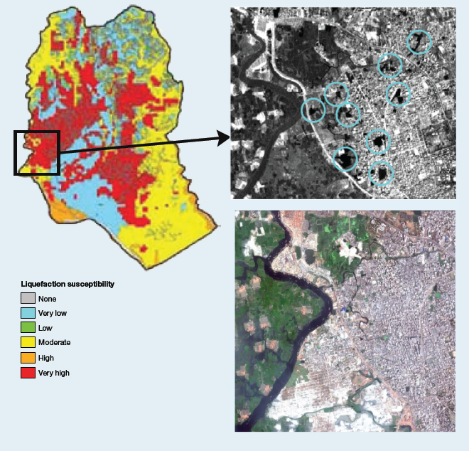
(Source: Rahman, 2010
Rahman, A. 2010. Dhaka's peripheral development and vulnerability to earthquake liquefaction effects. Asian Disaster Management News 16 (1): 6–8. , adapted from IRS Image 1996 and Google Earth). Destroying retention ponds and drains increases risks of seasonal flooding just as building in drained wetlands increases earthquake risk. During an earthquake, sands and silts can liquefy to the point where the soil no longer supports the weight of buildings and infrastructure, which may subsequently collapse or suffer heavy damage. Dhaka’s wetlands, drained and filled with sand for housing development, are prime candidates for liquefaction. With little contemporary experience of earthquakes, Dhaka is vulnerable and ill-prepared. The older part of the city is home to densely populated, multi-storey, unreinforced brick buildings predisposed to heavy damage in a strong earthquake (Paul and Bhuiyan, 2010 Paul, B. and Bhuiyan, R. 2010. Urban earthquake hazard: Perceived seismic risk and preparedness in Dhaka city, Bangladesh. Disasters 34 (2): 337–359. ). And despite guidelines for earthquake-resistant construction, faulty design and poor quality materials and workmanship mean that many modern reinforced concrete buildings are also vulnerable.Available at http://www.ncbi.nlm.nih.gov/pubmed/19863568. An innovative cyclone shelter programme has helped Bangladesh dramatically reduce cyclone mortality since the 1970s. In the past four decades, Bangladesh has been struck by three severe cyclones: Bhola (1970), Gorky (1991) and Sidr (2007). Bhola caused an estimated 300,000 deaths and Gorky was responsible for more than 138,000. The death toll for Sidr, however, was ‘only’ around 4,000 (EM-DAT, 2010a EM-DAT (The OFDA/CRED International Disaster Database). 2010a. Disaster country profile: Bangladesh. Brussels, Belgium: Université Catholique de Louvain. ).1 Unfortunately, the disaster management capacities that have reduced cyclone mortality have not been able to address earthquake risk in Dhaka. Consistent with this, Bangladesh’s Hyogo Framework for Action (HFA) report (see Chapter 4 for more on HFA reporting) highlights that although there is an Earthquake Zoning Plan for Dhaka, its enforcement and general urban improvement remain major challenges. Dhaka’s expansion vividly illustrates how drivers such as badly planned and managed urbanization, ecosystem decline and poverty interact to build risk over time (UNISDR, 2009.  UNISDR (United Nations International Strategy for Disaster Reduction). 2009. Global assessment report on disaster risk reduction: Risk and poverty in a changing climate. Geneva, Switzerland: United Nations International Strategy for Disaster Reduction. UNISDR (United Nations International Strategy for Disaster Reduction). 2009. Global assessment report on disaster risk reduction: Risk and poverty in a changing climate. Geneva, Switzerland: United Nations International Strategy for Disaster Reduction.Click here to go to GAR09 page. Until recently there was only one seismic observatory in Bangladesh (in Chittagong in the country’s southeast), although in recent years seismic monitoring capacity has increased, with new observatories in Sylhet, Rangpur and Gazipur (Paul and Bhuiyan, 2010 Paul, B. and Bhuiyan, R. 2010. Urban earthquake hazard: Perceived seismic risk and preparedness in Dhaka city, Bangladesh. Disasters 34 (2): 337–359. ). This means that earthquake hazard in the area may not be fully understood, despite the certainty of a severe earthquake one day. With its population growing at around 6 percent annually, risk can only increase unless vulnerability is drastically reduced.
Dhaka highlights the complex processes that configure risk and the challenges they pose for effective disaster risk governance. For example, extensive risk associated with flooding can contribute to intensive risk associated with earthquakes (see the Preface for definitions of extensive and intensive risk). However, apparent success in reducing mortality from tropical cyclone disasters has not translated into improvements in the management of earthquake risk. The multiple feedback loops that exist among urbanization, ecosystem decline, poverty and governance, configure risk while simultaneously obscuring causality. In attempting to reduce risks associated with a range of hazards, authorities must make trade-offs between them.Available at http://www.ncbi.nlm.nih.gov/pubmed/19863568. To begin to unravel the complexity of multiple interrelated risk drivers, this chapter explores global trends in the mortality and economic loss risk associated with tropical cyclones and floods (Box 2.2), and with the losses and damages associated with extensive risks. It also examines the impacts of disasters on children and on internal displacement, and introduces a number of potential emerging risks. Box 2.2 Updating the global risk analysis
GAR09 analysed global patterns of mortality risk and economic loss risk for tropical cyclones,
floods, landslides and earthquakes, and the underlying risk drivers that explained those patterns. In
GAR11, all the datasets used in the global risk analysis have been updated to 2010 and can be explored
for tropical cyclones, floods and landslides using the online Global Risk Data Platform
(www.preventionweb.net/gar). The same methodology and statistical models that underpinned the
GAR09 analysis of global risk have been used for GAR11, given that two years of additional data is
unlikely to lead to significant changes in the value of the statistical regressions (Peduzzi et al., 2010 Peduzzi, P., Chatenoux, B., Dao, H., De Bono, A., Herold, H., Kossin, J., Mouton, F. and Nordbeck, O. 2010. Global trends in human exposure, vulnerability and risk from tropical cyclones. JOURNAL (submitted). ).2 . Following an in-depth revision of the earthquake risk model,3 it was decided not to update the earthquake risk analysis until new datasets from the United States Geological Survey and the Global Earthquake Model become available. GAR11, therefore, does not include an earthquake risk analysis. GAR11 explores trends over time between 1970 and 2010 for tropical cyclones and floods for World Bank geographic and income regions.4 These trends are explored using modelled disaster risk rather than recorded disaster losses which do not provide a solid platform for estimating trends. Most recorded losses are concentrated in a very small number of infrequent intensive disasters with long return periods. The occurrence of one or more intensive disasters in any given decade, therefore, distorts any underlying trend. In addition, trends identified using reported losses also reflect improved disaster reporting over time. Satellite data indicate that on average, between 142 and 155 countries have been hit by tropical cyclones every year since 1970 (Table 2.1).5 However, the number of internationally reported cyclone disasters tripled between the 1970s and 2010. This trend is only partly due to increasing exposure and cyclone severity; it is mostly induced by improved reporting and access to information (Peduzzi et al., 2010, 2011).
Table 2.1 Trend of tropical cyclones reported versus tropical cyclones detected by satellite during the last four decades
The trend analysis estimates changes in vulnerability and exposure. Although factors such as climate change and variability and environmental degradation influence hazard levels, data limitations mean that, in the case of floods, hazard has been treated as constant. In contrast, thanks to a new and more complete data set, changes in the frequency and severity of tropical cyclones have been accounted for in the calculation of tropical cyclone exposure (Tables 2.3 and 2.5 and Figure 2.10). Tropical cyclone risk (Figures 2.12, 2.15 and 2.17) has been estimated using modelled exposure and modelled tropical cyclone frequency based on observations from 1970 to 2010. It is expected that trends in extreme hazards will be addressed in more detail in the IPCC Special Report on Managing the Risks of Extreme Events and Disasters to Advance Climate Change Adaptation (SREX), which is scheduled for publication in 2011. Notes 1 The low mortality in Sidr does not imply that the next severe cyclone to hit Bangladesh will have similar impacts. Although encouraging, one success story is not sufficient to prove that mortality risk has been definitively reduced. 2 Since the launch of GAR09, the number of tropical cyclones analysed has increased from 2,510 to more than 4,100, and an additional seven years of data have been included (1970–2009). For GAR09, cyclone risk was analysed only up to 300 km inland. Following expert review this limit has been removed. The algorithm for calculating average cyclone frequencies has also been improved and a new method for country level aggregation introduced. As a consequence tropical cyclone exposure has been calcualted differently in GAR11 compared with GAR09. The GAR11 flood analysis has also been improved and includes data from the hydroshed model for Canada, Mexico and the United States of America, which was not available for GAR09. 3 Norwegian Geotechnical Institute, Expert group meeting Earthquake Hazard and Risk Modelling Workshop, 12–13 October 2009, Oslo, Norway. 4 It is important to note that geographic regions may disguise strong inter-regional differences. For example, the fact that China and Pacific Islands such as Nauru and Vanuatu are part of East Asia and the Pacific does not mean that they are experiencing similar processes of risk construction. For World Bank income and geographic regions, see www.data.worldbank.org/country. 5 This is the number of countries affected by cyclones that make landfall. One cyclone can affect several countries, but many tropical cyclones never make landfall and are thus not included. |

| |


 GAR 2011 Contributing Papers