Maps show the real threat of climate-related subsidence to British homes and properties
New maps launched by the British Geological Survey (BGS) reveal how climate change is likely to drive an increase in subsidence-related issues for British homes and properties over the next 50 years.
Experts at the BGS, the UK’s geoscientific advisor which helps to advance our knowledge about changes in the environment, warns that the number of properties in Great Britain facing subsidence issues and damage to property from shrink-swell is on the rise, with figures of just 3 per cent in 1990 likely to reach 10 per cent by 2070.
Shrinking and swelling of the ground, often reported as subsidence, is already one of the most damaging geohazards in Britain today, costing the economy an estimated £3 billion over the past decade.
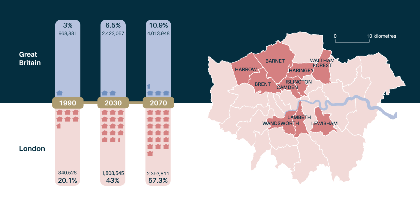
Projected number of properties highly likely or extremely likely to be affected by clay shrink-swell due to climate change (left) and London boroughs at greatest risk to be affected by 2070. BGS © UKRI.
BGS has combined geotechnical information about potential ground movement, with data about long-term rainfall and temperature scenarios, to identify the areas of Britain most likely to become susceptible to shrink-swell subsidence in the future.
Based on one of four new BGS datasets, the information traces the impact of climate change from 1990 and reveals important projections for the next decade, as well as future projections up to 2070.
They represent the worst-case scenario if Britain were to take no action to reduce carbon emissions, using scaled values which highlight the areas with the highest susceptibility to shrink-swell subsidence activity driven by a changing climate.
Shrink-swell refers to changes in soil volume due to moisture changes in the ground. When clay-rich soils absorb lots of water, swelling pressures can cause the ground to rise and structures to lift, known as heave. In warmer, drier weather, soils can become very hard when dry. As a result, the ground shrinks and cracks, leading to subsidence.
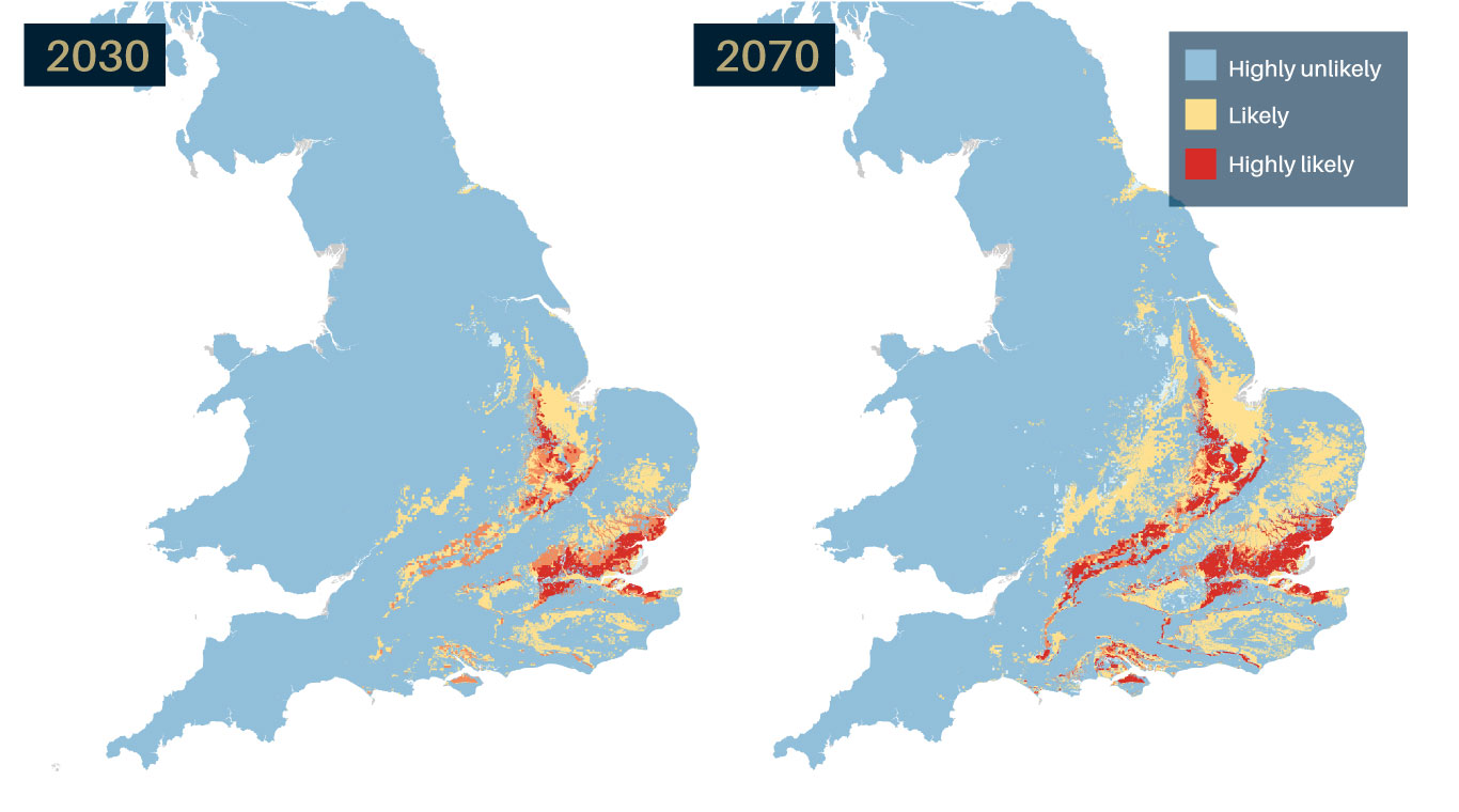
GeoClimate UKCP18 projections, identifying areas expected to experience the largest increases in susceptibility to subsidence by 2030 and 2070. Source: BGS © UKRI.
BGS says that highlighting potential hazards early will help local authorities, developers and property owners to increase resilience to climate changes, plan effectively and reduce their exposure to potentially high remediation costs.
According to projections, more than three per cent of properties are likely to be affected across Great Britain by 2030, and almost three times that number (10.9 per cent), by 2070.
‘By combining our extensive geology survey data and geological expertise to UK Climate Projection scenarios (UKCP18), we can highlight those areas most vulnerable to shrink–swell subsidence due to future climate change. This is important information that can help communities and property owners to build resilience to future climate change.’
Patrick Gray, BGS Head of Digital Products.

Most susceptible are properties in the highly-populated London areas, particularly in northern and central London boroughs, and Kent in the South East. Projections suggest that the number of properties in London likely to be affected by climate will rise from 20 per cent in 1990, to 43 per cent by 2030, and almost 3 times 1990 values (57 per cent) by 2070.
‘Of particular interest are areas with clay-rich soils that shrink and swell with changes in moisture. For example in the South East, many of the clay formations are too young to have been changed into stronger mud rocks, leaving them vulnerable to absorb and lose moisture.
‘Added to that, Britain is seeing increasingly variable climates. In summer 2018 for example, we experienced some of the warmest and driest summer months in years, whereas 2019 was one of the wettest on record.
‘Dry weather and high temperatures are a major factor in the emergence of shrink-swell subsidence and looking to the future, these increases in annual temperatures and variability in rainfall are very likely to continue.
‘This is going to be a major factor in the emergence of future shrink-swell activity, which needs careful monitoring, mitigation and potentially costly remediation activity.’
Lee Jones, BGS Engineering Geologist.
Shrink-swell subsidence can lead to financial loss for anyone involved in the ownership or management of property, major infrastructure works and utilities, including developers, householders and local government.
These costs can lead to increased insurance premiums, depressed house prices and in some cases, engineering works to stabilise land or property and replacement of utility pipeworks and unstable transport infrastructure.
However, experts at the BGS say it is important to understand there are steps that property owners can take to limit the future impact of shrink-swell subsidence on properties.
‘Whilst we should be careful to note that these are projections, property owners can help to limit the potential effects of future subsidence-related issues.
‘Whilst it may not be possible for everyone, it’s advisable for those living in an area showing an increased susceptibility under future climate conditions to seek specialist advice before starting any major building work. This can be done by a suitably qualified expert such as a structural surveyor, geotechnical engineer or chartered engineering geologist.
‘Other steps property owners can take is to be aware of the effects of laying impermeable drives, paths or hardstanding and of planting or removing trees close to properties, which can all have an impact on soil moisture profiles.’
Lee Jones, BGS Engineering Geologist.
BGS has made further advice publicly available online, together with GeoClimate UKCP18 open data. A second open dataset is also available based on a medium emissions scenario (UKCP09).
Premium information is available through two further licensed datasets, which include projections for average, wetter and drier climate conditions based on medium and higher emissions scenarios across variable time periods.