An open-source tool to assist in multi-hazard risk assessment
Effective risk assessment and management are essential for mitigating the impacts of hazards and building resilient communities. A new open-source tool, RiskChanges, can help inform decision-making and guide resource allocation.
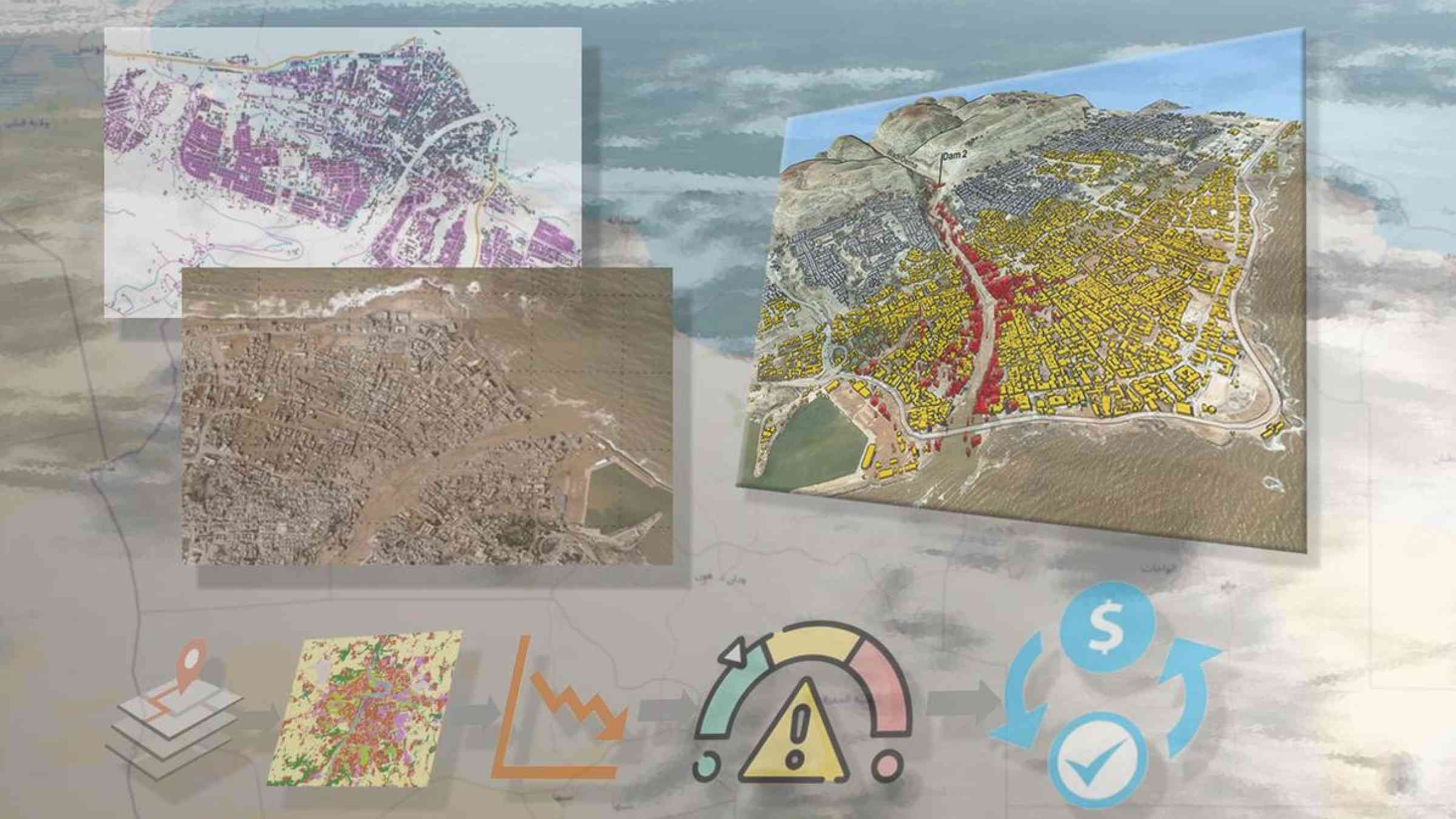
In the immediate aftermath of the September 2023 Derna flood disaster in Libya, a number of available tools allowed rapid assessment of the situation to facilitate the response and reduce further risks. These included the creation of a flood hazard map – using an open-source tool, Fastflood - and the extraction of building footprints using Google Open Buildings dataset.
Another open-source tool was used to conduct an exposure analysis: RiskChanges.
RiskChanges is an open-source cloud-based spatial decision support tool using a dynamic and comprehensive approach to multi-hazard risk assessment. It is designed to support orgaizations in assessing and managing risks associated with multiple hazards at the local level to select optimal risk reduction alternatives.
RiskChanges was developed by the University of Twente in collaboration with the Asian Institute of Technology, GeoInformatics Centre. This initiative seeks to fill a gap in the market for risk assessment tools: meeting the need for publicly available, versatile tools for multi-hazard risk that can be used easily by local authorities, applicable to a spectrum of international contexts. RiskChange can be used at different stages of the risk reduction and risk management processes: to evaluate potential risks before and event, and to manage existing risks during the recovery phase.
Features to support effective risk assessment and analysis
The software has a wide range of features to support effective risk assessment and analysis, including:
- Multi-user functionality: RiskChanges lets users to collaborate on multiple projects within an organization or among multiple organizations. This feature enables different stakeholders –such as risk analysts, researchers, and decision-makers – to work together and contribute their input data and insights into the projects.
- Multi-hazard assessment: Users can perform risk assessments for various natural and manmade hazards. This feature considers the potential interactions and cumulative effects of different hazards, providing a more comprehensive understanding of the overall risks.
- Multi-asset analysis: The tool supports the analysis of different asset types with varying spatial characteristics. Assets can include infrastructure, buildings, populations, and other tangible human assets located in hazard-prone areas.
- Vulnerability database: RiskChanges includes a public vulnerability curve database that allows users to access and share physical vulnerability curves so that organizations can evaluate the susceptibility of their assets, infrastructure, and communities to different hazards by considering factors such as building types, infrastructure standards, and societal vulnerabilities.
- Modelling: Its comprehensive risk framework takes into account hazard intensity or susceptibility, vulnerability and exposure to estimate the qualitative risk associated with the single or multiple hazards in the area of interest.
- Risk comparison: Users can assess the risk associated with their current situation and compare it with possible future scenarios or risk reduction planning alternatives.
- Spatial analysis and visualization: RiskChanges offers advanced visualization and analysis capabilities. Users can analyze risk spatially and create risk maps that illustrate the interaction between hazard types and the associated loss estimates.
- Data management: RiskChanges allows users to upload hazard maps, element-at-risk maps, administrative unit data, risk reduction planning alternatives, and possible future scenarios.
The benefits of an open-source tool
Using an open-source tool like RiskChanges offers several advantages:
- Cost-effectiveness: The tool is freely available, enabling organizations to economise by avoiding software licenses.
- Flexibility: Open-source tools let users customize and modify the software according to their specific needs. RiskChanges allows organizations to tailor the tool to their requirements, enhancing its usability and effectiveness.
- Transparency: Open-source tools are developed and maintained by a community of users and contributors: this enhances transparency and accountability.
- Collaboration: Open-source tools promote collaboration and knowledge sharing among users, encouraging the development of innovative solutions and iterative improvements.
Applications
- Risk assessment and mapping: RiskChanges can be used to assess and map risks associated with multiple hazards at the local level. This information can be used to identify high-risk areas and prioritize mitigation efforts.
- Risk reduction planning: Users can evaluate the effectiveness of different risk reduction alternatives and select the optimal options.
- Disaster preparedness and response: The tool can be used to develop disaster preparedness and response plans. For example, it can help identify evacuation routes and shelter locations.
- Climate change adaptation: RiskChanges can be used to assess the impacts of climate change on hazard risks and develop adaptation strategies.
View more videos on the different features of RiskChanges.
Global interest and uptake
In addition to its use in the aftermath of Libya’s Derna flooding disaster, we have demonstrated the tool’s utility in arrange of contexts around the world:
EU Horizon Europe PARATUS project
The EU Horizon Europe PARATUS project aims to increase the preparedness of first and second responders in the face of multi-hazard events, and to reduce the risks associated with complex disasters’ cross-sectoral impacts. RiskChanges will be used to develop a cloud-based Online Service Platform that offers support in reducing dynamic risk scenarios and systemic vulnerability caused by multi-hazard disasters. The project will perform in-depth assessments of complex hazard interactions and their resulting impacts, and study how future scenarios could change impacts. These scenarios of multi-hazard impacts will be co-designed with stakeholders and developed in four case-study areas (including the Caribbean, Romania, Istanbul, and Alpine areas).
Nepal
RiskChanges has been applied in a USAID-funded project in two of Nepal’s municipalities. This has attracted the interest of Nepal’s National Disaster Risk Reduction and Management Authority (NDRRMA), who have indicated that they would like to adopt the system for use in other municipalities. The World Bank, Nepal, has also approached ITC to develop a project proposal on multi-Hazard risk assessment in Nepal, with RiskChanges as an important component.
India
ITC has been working with the Kerala State Disaster Management Authority (KSDMA) for a number of years. KSDMA has expressed interest in using RiskChanges as a tool for risk-sensitive land use planning at local level.
SADC
The Global Water Partnership Southern Africa has approached ITC to assist in developing a proposal for the Green Climate Fund for disaster preparedness and response in the Southern African Development Community (SADC) countries, with RiskChanges as an integral component.
Carribbean
ITC has demonstrated RiskChanges to the Caribbean Emergency and Disaster Management Authority (CDEMA), who asked ITC to be in the task group for multi-hazard risk assessment in the Caribbean, expressing their interest in the tool, which fills an identified gap.
Capacity building
The RiskChanges tool has been put to use in several recent training sessions: for flood risk assessment in Bhutan; for training on digital technologies for DRR in Sri Lanka; a global training session on dynamic multi-hazard risk assessment for risk reduction planning; and at the Vienna International School of Earth and Space Sciences (VISESS) Summer School programme on Risk and Resilience.
In each of these training sessions, the RiskChanges tool served as a practical resource for participants to gain insights into dynamic multi-hazard risk assessment, evaluating risk reduction alternatives and analysing changing risk in future scenarios.
The valuable feedback and insights gathered from participants have further improved the tool, enhancing its effectiveness for upcoming training and risk assessment activities.
Cees van Westen is a Full Professor of Multi-Hazard Risk Dynamics at the faculty of Geo-information Science and Earth Observation (ITC), Twente University, the Netherlands. With expertise in natural hazard and risk assessment, he has conducted research projects worldwide. Currently, his research primarily focuses on developing methodologies for analysis of changing multi-hazard risk and using them as decision support tools for risk reduction planning. Westen's work has made significant contributions to the field, advancing the understanding and management of natural hazards. Furthermore, he actively shares his expertise through training courses and workshops, playing a key role in capacity building efforts worldwide.
Email: c.j.vanwesten@utwente.nl
Rabina Twayana is a passionate geospatial professional with approximately 3 years of experience in the geospatial sector. Currently, she is employed as a Research Associate at the GeoInformatics Research Centre, Asian Institute of Technology in Thailand. With her enthusiasm and expertise, she has been contributing to GIS based web application development related projects. At present, she is actively engaged in research activities that leverage advanced geospatial technologies and methodologies to address real-world challenges, particularly in disaster risk analysis and management. She aims to make meaningful contributions in the geospatial community and contribute to the development of innovative solutions that have a positive impact on society.
Email: rabinatwayana@ait.asia